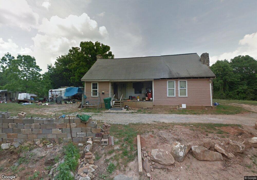
35 Foster Ln Bowdon, GA 30108
Estimated Value: $161,247 - $302,000
3
Beds
1
Bath
1,148
Sq Ft
$190/Sq Ft
Est. Value
About This Home
This home is located at 35 Foster Ln, Bowdon, GA 30108 and is currently estimated at $218,082, approximately $189 per square foot. 35 Foster Ln is a home located in Carroll County with nearby schools including Mt. Zion Elementary School, Mt. Zion Middle School, and Mt. Zion High School.
Ownership History
Date
Name
Owned For
Owner Type
Purchase Details
Closed on
Mar 20, 2019
Sold by
Reid Bobby
Bought by
Hindmon Franklin R
Current Estimated Value
Purchase Details
Closed on
Apr 24, 2017
Sold by
Thomas Robert L
Bought by
Reid Bobby
Purchase Details
Closed on
Mar 2, 2017
Sold by
Smith Julian David
Bought by
Thomas Robert L
Purchase Details
Closed on
Jan 26, 2017
Sold by
Smith Harold A
Bought by
Smith David
Purchase Details
Closed on
Mar 5, 2014
Sold by
Puckett C J
Bought by
Smith Harold
Purchase Details
Closed on
Nov 14, 2002
Sold by
Puckett C J
Bought by
Puckett C J
Purchase Details
Closed on
Nov 6, 2002
Sold by
Harper Jerry G
Bought by
Puckett C J
Purchase Details
Closed on
Mar 25, 1992
Sold by
Harper Jerry and Harper Usan
Bought by
Harper Jerry G
Purchase Details
Closed on
Aug 6, 1991
Bought by
Harper Jerry and Harper Usan
Create a Home Valuation Report for This Property
The Home Valuation Report is an in-depth analysis detailing your home's value as well as a comparison with similar homes in the area
Home Values in the Area
Average Home Value in this Area
Purchase History
| Date | Buyer | Sale Price | Title Company |
|---|---|---|---|
| Hindmon Franklin R | -- | -- | |
| Reid Bobby | $12,000 | -- | |
| Thomas Robert L | $10,000 | -- | |
| Smith David | -- | -- | |
| Smith Harold | $3,200 | -- | |
| Puckett C J | -- | -- | |
| Puckett C J | $34,000 | -- | |
| Harper Jerry G | -- | -- | |
| Harper Jerry | $17,900 | -- |
Source: Public Records
Tax History
| Year | Tax Paid | Tax Assessment Tax Assessment Total Assessment is a certain percentage of the fair market value that is determined by local assessors to be the total taxable value of land and additions on the property. | Land | Improvement |
|---|---|---|---|---|
| 2025 | $758 | $43,204 | $21,275 | $21,929 |
| 2024 | $766 | $43,204 | $21,275 | $21,929 |
| 2023 | $766 | $28,936 | $17,020 | $11,916 |
| 2022 | $384 | $20,989 | $11,347 | $9,642 |
| 2021 | $329 | $17,420 | $9,077 | $8,343 |
| 2020 | $292 | $15,386 | $8,252 | $7,134 |
| 2019 | $380 | $14,669 | $8,322 | $6,347 |
| 2018 | $126 | $12,948 | $7,778 | $5,170 |
| 2017 | $292 | $11,067 | $7,778 | $3,289 |
| 2016 | $26 | $11,067 | $7,778 | $3,289 |
| 2015 | $402 | $14,367 | $6,000 | $8,367 |
| 2014 | $403 | $14,367 | $6,000 | $8,367 |
Source: Public Records
Map
Nearby Homes
- 353 S Prospect Ave
- 828 Harrison Rd
- Melear Rd
- 4141 Mount Zion Rd
- 140 Martin Cemetery Rd
- 1405 Burwell Rd
- 128 Martin Cemetery Rd
- 120 Martin Cemetery Rd
- 183 Madden Rd
- 1000 Kansas Jake Rd
- 85 Eureka Church Rd Unit 152
- 213 Randall Dr
- 206 Randall Dr
- 141 Anita Blvd
- 218 Randall Dr
- 768 Burwell Rd
- 46 Gammon Rd
- 1495 Kansas Jake Rd
- 0 Kansas Jake Rd Unit 26132658
- 0 Kansas Jake Rd Unit 10676294
- 1405 Davenport Mill Rd
- 1524 Davenport Mill Rd
- 1350 Davenport Mill Rd
- 310 Caldwell Rd
- 420 Delia Peace Rd
- 845 Smith Chapel Rd
- 25 Wilson Way
- 1197 Davenport Mill Rd
- 785 Smith Chapel Rd
- 382 Delia Peace Rd
- 41 Wilson Way
- 244 Caldwell Rd
- 243 Caldwell Rd
- 782 Smith Chapel Rd
- 170 Simms Rd
- 1708 Davenport Mill Rd
- 180 Simms Rd
- 742 Smith Chapel Rd
- 190 Simms Rd
- 301 Caldwell Rd
Your Personal Tour Guide
Ask me questions while you tour the home.