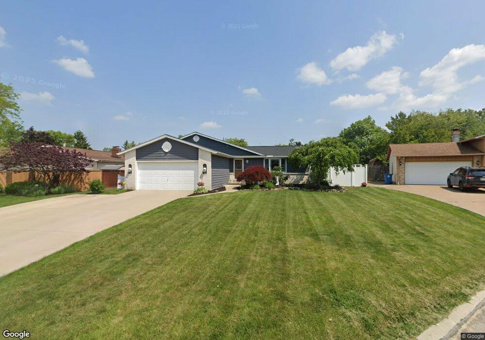
351 Quail Ct Amherst, OH 44001
Estimated Value: $293,278 - $318,000
3
Beds
2
Baths
2,140
Sq Ft
$143/Sq Ft
Est. Value
About This Home
This home is located at 351 Quail Ct, Amherst, OH 44001 and is currently estimated at $306,320, approximately $143 per square foot. 351 Quail Ct is a home located in Lorain County with nearby schools including Powers Elementary School, Walter G. Nord Middle School, and Amherst Junior High School.
Ownership History
Date
Name
Owned For
Owner Type
Purchase Details
Closed on
Jun 19, 2007
Sold by
Mismas Robert and Mismas Teresa M
Bought by
Janik David A and Janik Jeana M
Current Estimated Value
Home Financials for this Owner
Home Financials are based on the most recent Mortgage that was taken out on this home.
Original Mortgage
$143,500
Interest Rate
6.2%
Mortgage Type
Purchase Money Mortgage
Purchase Details
Closed on
Jul 24, 2000
Sold by
Ross Grace M
Bought by
Mismas Robert and Mismas Teresa M
Home Financials for this Owner
Home Financials are based on the most recent Mortgage that was taken out on this home.
Original Mortgage
$152,914
Interest Rate
8.27%
Create a Home Valuation Report for This Property
The Home Valuation Report is an in-depth analysis detailing your home's value as well as a comparison with similar homes in the area
Home Values in the Area
Average Home Value in this Area
Purchase History
| Date | Buyer | Sale Price | Title Company |
|---|---|---|---|
| Janik David A | $157,000 | First American | |
| Mismas Robert | $153,000 | Insignia Title |
Source: Public Records
Mortgage History
| Date | Status | Borrower | Loan Amount |
|---|---|---|---|
| Closed | Janik David A | $143,500 | |
| Closed | Mismas Robert | $152,914 |
Source: Public Records
Tax History
| Year | Tax Paid | Tax Assessment Tax Assessment Total Assessment is a certain percentage of the fair market value that is determined by local assessors to be the total taxable value of land and additions on the property. | Land | Improvement |
|---|---|---|---|---|
| 2024 | $3,490 | $86,272 | $15,365 | $70,907 |
| 2023 | $3,108 | $64,750 | $11,501 | $53,249 |
| 2022 | $2,980 | $64,750 | $11,501 | $53,249 |
| 2021 | $2,932 | $63,574 | $11,501 | $52,073 |
| 2020 | $2,875 | $55,330 | $10,010 | $45,320 |
| 2019 | $2,817 | $55,330 | $10,010 | $45,320 |
| 2018 | $2,832 | $55,330 | $10,010 | $45,320 |
| 2017 | $2,900 | $53,230 | $8,810 | $44,420 |
| 2016 | $2,923 | $53,230 | $8,810 | $44,420 |
| 2015 | $2,907 | $53,230 | $8,810 | $44,420 |
| 2014 | $2,729 | $49,740 | $8,230 | $41,510 |
| 2013 | $2,738 | $49,740 | $8,230 | $41,510 |
Source: Public Records
Map
Nearby Homes
- 1260 Meadowview Ln
- 423 Quarry Creek Dr
- 239 Habant Dr
- 1011 N Main St
- 110 Habant Dr
- 120 Springvale Dr
- 110 Beaver Creek Trail
- 707 Lincoln St
- 3932 Courtyard Dr
- 4872 Leavitt Rd
- 703 N Main St
- 4518 Santina Way
- 4497 Bellow Dr
- 1215 Spruce Tree Ln
- 4195 Jenee Dr
- 645 Terra Ln
- 4513 Vineyard Dr
- 5946 N Mayflower Dr
- 4253 Santina Way
- 4459 Bellow Dr
- 1141 Meadowbrook Dr
- 369 Quail Ct
- 356 Killdeer Dr
- 338 Killdeer Dr
- 27 Meadowbrook Ct
- 338 Killdeer Ct
- 374 Killdeer Dr
- 401 Quail Ct
- 354 Quail Ct
- 320 Killdeer Dr
- 1121 Meadowbrook Dr
- 400 Quail Ct
- 372 Quail Ct
- 402 Killdeer Dr
- 1142 Meadowbrook Dr
- 1134 Meadowbrook Dr
- 1140 Meadowview Ln
- 1126 Meadowbrook Dr
- 1150 Meadowview Ln
- 1154 Meadowbrook Dr
Your Personal Tour Guide
Ask me questions while you tour the home.