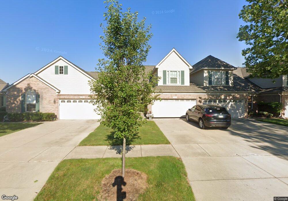
355 Carson Dr Unit 152 Westland, MI 48185
Estimated Value: $270,000 - $304,000
About This Home
This home is located at 355 Carson Dr Unit 152, Westland, MI 48185 and is currently estimated at $290,290, approximately $158 per square foot. 355 Carson Dr Unit 152 is a home located in Wayne County with nearby schools including P.D. Graham Elementary School, Adlai Stevenson Middle School, and John Glenn High School.
Ownership History
We collect this data history from publicly available records. To have your information removed, we recommend requesting removal directly through your county’s website.
Purchase Details
Purchase Details
Home Financials for this Owner
Home Financials are based on the most recent Mortgage that was taken out on this home.Purchase Details
Purchase Details
Home Values in the Area
Average Home Value in this Area
Purchase History
We collect this data history from publicly available records. To have your information removed, we recommend requesting removal directly through your county’s website.
| Date | Buyer | Sale Price | Title Company |
|---|---|---|---|
| -- | None Listed On Document | ||
| -- | None Listed On Document | ||
| -- | Silk Abstract Company | ||
| $216,570 | Greco | ||
| $34,640 | Greco |
Mortgage History
We collect this data history from publicly available records. To have your information removed, we recommend requesting removal directly through your county’s website.
| Date | Status | Borrower | Loan Amount |
|---|---|---|---|
| Previous Owner | $152,000 |
Tax History
We collect this data history from publicly available records. To have your information removed, we recommend requesting removal directly through your county’s website.
| Year | Tax Paid | Tax Assessment Tax Assessment Total Assessment is a certain percentage of the fair market value that is determined by local assessors to be the total taxable value of land and additions on the property. | Land | Improvement |
|---|---|---|---|---|
| 2025 | $2,867 | $126,500 | $0 | $0 |
| 2024 | $2,812 | $118,200 | $0 | $0 |
| 2023 | $2,685 | $106,500 | $0 | $0 |
| 2022 | $3,099 | $96,700 | $0 | $0 |
| 2021 | $3,021 | $92,800 | $0 | $0 |
| 2020 | $2,986 | $88,700 | $0 | $0 |
| 2019 | $2,841 | $83,400 | $0 | $0 |
| 2018 | $2,179 | $76,600 | $0 | $0 |
| 2017 | $981 | $73,000 | $0 | $0 |
| 2016 | $2,757 | $71,200 | $0 | $0 |
| 2015 | $5,394 | $60,770 | $0 | $0 |
| 2013 | $5,225 | $53,570 | $0 | $0 |
| 2012 | $2,566 | $54,900 | $0 | $0 |
Map
- 435 Carson Dr Unit 146
- 39020 Florence Ave
- 127 S John Hix St
- 310 Marigold Cir Unit 56
- 210 Marigold Cir Unit 7
- 348 Meadowlake Rd
- 212 Charterhouse Dr
- 39805 Coronation Rd
- 870 N Lotz Rd
- 700 N Lotz Rd
- 39385 Dillingham St
- 381 S Norma St
- 300 Avium Ln Unit 61
- 39240 Nottingham St
- 39206 Nottingham St
- 39734 Scottsdale Dr
- 1218 Barchester St
- 1750 N Hix Rd
- 1243 Springer St
- 38032 Hixford Place Unit 20
- 280 Carson Dr Unit 130
- 112 Carson Dr Unit 112
- 163 Carson Dr Unit 174
- 118 Carson Dr Unit 113
- 154 Carson Dr Unit 119
- 240 Carson Dr Unit 127
- 235 Carson Dr Unit 160
- 245 Carson Dr Unit 159
- 199 Carson Dr Unit 167
- 332 Brookfield Dr Unit 9
- 362 Brookfield Dr Unit 16
- 304 Brookfield Dr Unit 2
- 316 Brookfield Dr Unit 5
- 320 Brookfield Dr Unit 6
- 365 Carson Dr Unit 151
- 250 Carson Dr Unit 128
- 362 Brookfield Dr Unit 111
- 382 Brookfield Dr Unit 21
- 344 Brookfield Dr Unit 12
- 356 Brookfield Dr Unit 14
Ask me questions while you tour the home.