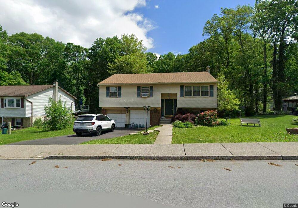
357 Chestnut St Alburtis, PA 18011
Estimated Value: $345,000 - $419,000
3
Beds
2
Baths
1,742
Sq Ft
$211/Sq Ft
Est. Value
About This Home
This home is located at 357 Chestnut St, Alburtis, PA 18011 and is currently estimated at $368,390, approximately $211 per square foot. 357 Chestnut St is a home located in Lehigh County with nearby schools including Alburtis Elementary School, Lower Macungie Middle School, and Emmaus High School.
Ownership History
Date
Name
Owned For
Owner Type
Purchase Details
Closed on
Sep 5, 2023
Sold by
Confer Ann Marie
Bought by
Confer Ann Marie
Current Estimated Value
Purchase Details
Closed on
Feb 29, 1984
Sold by
Confer Richard L and Confer Eileen K
Bought by
Confer Richard L and Confer Eileen K
Purchase Details
Closed on
Apr 15, 1981
Bought by
A J W Inc
Create a Home Valuation Report for This Property
The Home Valuation Report is an in-depth analysis detailing your home's value as well as a comparison with similar homes in the area
Home Values in the Area
Average Home Value in this Area
Purchase History
| Date | Buyer | Sale Price | Title Company |
|---|---|---|---|
| Confer Ann Marie | -- | None Listed On Document | |
| Confer Richard L | -- | -- | |
| A J W Inc | $26,000 | -- |
Source: Public Records
Tax History
| Year | Tax Paid | Tax Assessment Tax Assessment Total Assessment is a certain percentage of the fair market value that is determined by local assessors to be the total taxable value of land and additions on the property. | Land | Improvement |
|---|---|---|---|---|
| 2026 | $5,246 | $173,700 | $39,900 | $133,800 |
| 2025 | $5,100 | $173,700 | $39,900 | $133,800 |
| 2024 | $4,970 | $173,700 | $39,900 | $133,800 |
| 2023 | $4,740 | $173,700 | $39,900 | $133,800 |
| 2022 | $4,640 | $173,700 | $133,800 | $39,900 |
| 2021 | $4,553 | $173,700 | $39,900 | $133,800 |
| 2020 | $4,515 | $173,700 | $39,900 | $133,800 |
| 2019 | $4,490 | $173,700 | $39,900 | $133,800 |
| 2018 | $4,439 | $173,700 | $39,900 | $133,800 |
| 2017 | $4,372 | $173,700 | $39,900 | $133,800 |
| 2016 | -- | $173,700 | $39,900 | $133,800 |
| 2015 | -- | $173,700 | $39,900 | $133,800 |
| 2014 | -- | $173,700 | $39,900 | $133,800 |
Source: Public Records
Map
Nearby Homes
- 428 Thomas St
- 52 W 5th St
- 22 Front St
- 112 Front St
- 122 Front St
- 314 Ridgeview Dr
- 442 Franklin St
- 226 Front St
- 317 W 2nd St
- 195 Maple Ct
- 3797 Chestnut Rd
- 7719 Barrow Dr
- 7707 Racite Rd
- 7524 Scenic View Dr
- 8640 Hensingersville Rd
- 8297 Mertztown Rd
- 46 Wetzel Rd
- 0 Clauss Hunt Knight Dr Unit 10 Units
- 3889 Fire Brick Rd
- 8014 Heritage Dr
- 341 Chestnut St
- 29 W School St
- 375 Chestnut St
- 333 Chestnut St
- 366 Chestnut St
- 107 W School St
- 354 Chestnut St
- 329 Chestnut St
- 340 Chestnut St
- 28 W School St
- 30 W School St
- 104 W School St
- 115 W School St
- 332 Chestnut St
- 110 W School St
- 317 Chestnut St
- 24 W School St
- 329 Walnut St
- 325 Walnut St
- 116 W School St
Your Personal Tour Guide
Ask me questions while you tour the home.