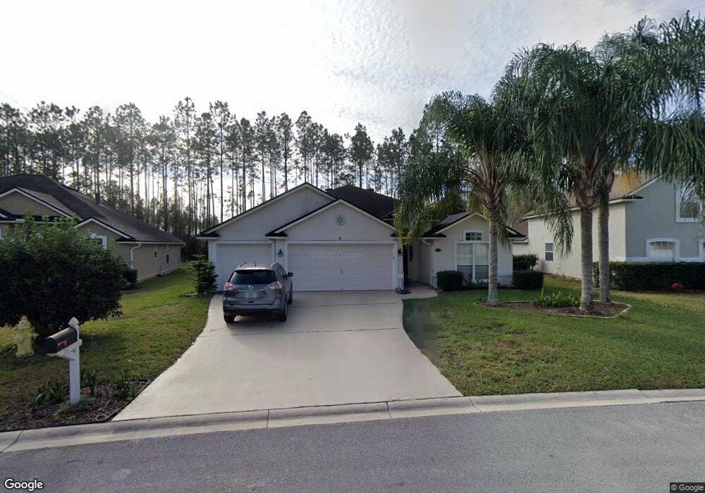
357 Sparrow Branch Cir Saint Johns, FL 32259
Estimated Value: $494,000 - $524,947
4
Beds
3
Baths
2,327
Sq Ft
$221/Sq Ft
Est. Value
About This Home
This home is located at 357 Sparrow Branch Cir, Saint Johns, FL 32259 and is currently estimated at $514,237, approximately $220 per square foot. 357 Sparrow Branch Cir is a home located in St. Johns County with nearby schools including Durbin Creek Elementary School, Fruit Cove Middle School, and Creekside High School.
Ownership History
Date
Name
Owned For
Owner Type
Purchase Details
Closed on
Sep 17, 2004
Sold by
D R Horton Inc Jacksonville
Bought by
Havekost Le Roy J and Havekost Eileen T
Current Estimated Value
Home Financials for this Owner
Home Financials are based on the most recent Mortgage that was taken out on this home.
Original Mortgage
$195,432
Outstanding Balance
$98,180
Interest Rate
6.75%
Mortgage Type
Purchase Money Mortgage
Estimated Equity
$416,057
Create a Home Valuation Report for This Property
The Home Valuation Report is an in-depth analysis detailing your home's value as well as a comparison with similar homes in the area
Home Values in the Area
Average Home Value in this Area
Purchase History
| Date | Buyer | Sale Price | Title Company |
|---|---|---|---|
| Havekost Le Roy J | $244,300 | Landamerica |
Source: Public Records
Mortgage History
| Date | Status | Borrower | Loan Amount |
|---|---|---|---|
| Open | Havekost Le Roy J | $195,432 |
Source: Public Records
Tax History
| Year | Tax Paid | Tax Assessment Tax Assessment Total Assessment is a certain percentage of the fair market value that is determined by local assessors to be the total taxable value of land and additions on the property. | Land | Improvement |
|---|---|---|---|---|
| 2025 | $3,959 | $262,646 | -- | -- |
| 2024 | $3,959 | $255,244 | -- | -- |
| 2023 | $3,959 | $247,810 | $0 | $0 |
| 2022 | $3,873 | $240,592 | $0 | $0 |
| 2021 | $3,597 | $233,584 | $0 | $0 |
| 2020 | $3,586 | $230,359 | $0 | $0 |
| 2019 | $3,635 | $225,180 | $0 | $0 |
| 2018 | $3,559 | $220,981 | $0 | $0 |
| 2017 | $3,519 | $216,436 | $0 | $0 |
| 2016 | $3,498 | $218,344 | $0 | $0 |
| 2015 | $3,549 | $216,825 | $0 | $0 |
| 2014 | $3,559 | $211,602 | $0 | $0 |
Source: Public Records
Map
Nearby Homes
- 383 Pine Haven Dr
- 49 Oak Shadow Place
- 4025 Lonicera Loop
- 250 Shadow Cove
- 509 Bent Creek Dr
- 4032 Lonicera Loop
- 184 Pine Haven Dr
- 155 Pine Haven Dr
- 4512 S Pennycress Place
- 321 Bent Creek Dr
- 4085 Lonicera Loop
- 237 Sparrow Branch Cir
- 908 W Doty Branch Ln
- 928 W Doty Branch Ln
- 1001 Andrea Way
- 408 S Elverton Place
- 30 Blue Hole Ct
- 27 Honey Blossom Rd
- 349 Lakeview Pass Way
- 969 W Tennessee Trace
- 361 Sparrow Branch Cir
- 353 Sparrow Branch Cir
- 2908 Cassia Ct
- 2658 Cassia Ct
- 2580 Cassia Ct
- 2574 Cassia Ct
- 2610 Cassia Ct
- 2864 Cassia Ct
- 2598 Cassia Ct
- 2592 Cassia Ct
- 2902 Cassia Ct
- 2640 Cassia Ct
- 2616 Cassia Ct
- 349 Sparrow Branch Cir
- 365 Sparrow Branch Cir
- 2493 Cassia Ct
- 345 Sparrow Branch Cir
- 2400 Cassia Ct
- 369 Sparrow Branch Cir
- 2416 Cassia Ct
Your Personal Tour Guide
Ask me questions while you tour the home.