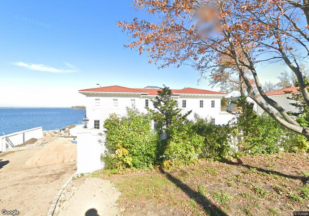
36 Sunset Rd Great Neck, NY 11024
Estimated Value: $5,931,963 - $7,852,000
4
Beds
6
Baths
6,217
Sq Ft
$1,069/Sq Ft
Est. Value
About This Home
This home is located at 36 Sunset Rd, Great Neck, NY 11024 and is currently estimated at $6,646,654, approximately $1,069 per square foot. 36 Sunset Rd is a home located in Nassau County with nearby schools including John F Kennedy School, Great Neck North Middle School, and Great Neck North High School.
Ownership History
Date
Name
Owned For
Owner Type
Purchase Details
Closed on
Jul 18, 2017
Sold by
36 Sunset Llc
Bought by
Hakimian Janet and Hakimian Joe
Current Estimated Value
Home Financials for this Owner
Home Financials are based on the most recent Mortgage that was taken out on this home.
Original Mortgage
$2,437,500
Outstanding Balance
$1,927,066
Interest Rate
2.6%
Mortgage Type
Adjustable Rate Mortgage/ARM
Estimated Equity
$4,719,588
Purchase Details
Closed on
Apr 6, 2017
Sold by
Cohn Marcia and Gaines Sherry
Bought by
36 Sunset Llc
Create a Home Valuation Report for This Property
The Home Valuation Report is an in-depth analysis detailing your home's value as well as a comparison with similar homes in the area
Home Values in the Area
Average Home Value in this Area
Purchase History
We collect this data history from publicly available records. To have your information removed, we recommend requesting removal directly through your county’s website.
| Date | Buyer | Sale Price | Title Company |
|---|---|---|---|
| Hakimian Janet | $3,750,000 | Judicial Title | |
| 36 Sunset Llc | $3,500,000 | First American Title Insuran |
Source: Public Records
Mortgage History
We collect this data history from publicly available records. To have your information removed, we recommend requesting removal directly through your county’s website.
| Date | Status | Borrower | Loan Amount |
|---|---|---|---|
| Open | Hakimian Janet | $2,437,500 |
Source: Public Records
Tax History
| Year | Tax Paid | Tax Assessment Tax Assessment Total Assessment is a certain percentage of the fair market value that is determined by local assessors to be the total taxable value of land and additions on the property. | Land | Improvement |
|---|---|---|---|---|
| 2025 | $104,566 | $6,937 | $3,081 | $3,856 |
| 2024 | $17,420 | $6,545 | $2,700 | $3,845 |
| 2023 | $119,035 | $7,405 | $3,081 | $4,324 |
| 2022 | $119,035 | $7,143 | $3,081 | $4,062 |
| 2021 | $125,463 | $4,749 | $2,389 | $2,360 |
| 2020 | $107,596 | $12,089 | $7,704 | $4,385 |
| 2019 | $104,195 | $12,089 | $7,704 | $4,385 |
| 2018 | $104,195 | $12,089 | $0 | $0 |
| 2017 | $77,246 | $12,089 | $7,704 | $4,385 |
| 2016 | $98,314 | $12,089 | $7,704 | $4,385 |
| 2015 | $20,770 | $12,089 | $7,704 | $4,385 |
| 2014 | $20,770 | $12,089 | $7,704 | $4,385 |
| 2013 | $19,822 | $12,089 | $7,704 | $4,385 |
Source: Public Records
Map
Nearby Homes
- 62 Stepping Stone Ln
- 258 Steamboat Rd
- 0 Kings Point Rd
- 232 KINGS POINT ROAD Kings Point Rd
- 3 Crestwood Place
- 2 Hewlett Place
- 3 Hewlett Place
- 18 Lighthouse Rd
- 199 B W Shore Rd
- 2 Pickwood Ln
- 13 Lighthouse Rd
- 6 Morris Ln
- 14 Martin Ct
- 16-B Hamptworth Dr
- 8 Cathy Ln
- 88 Steamboat Rd
- 14 Farmers Rd
- 91, 92 & 93 Gatsby Ln
- 8 Wesey Ct
- 19 Gilbert Rd
Your Personal Tour Guide
Ask me questions while you tour the home.