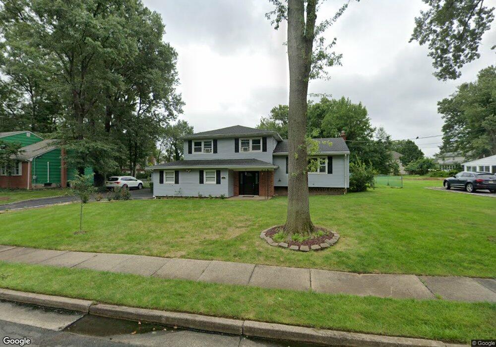
36 Ventnor Dr Edison, NJ 08820
Estimated Value: $817,690 - $977,000
4
Beds
3
Baths
1,959
Sq Ft
$455/Sq Ft
Est. Value
About This Home
This home is located at 36 Ventnor Dr, Edison, NJ 08820 and is currently estimated at $890,423, approximately $454 per square foot. 36 Ventnor Dr is a home located in Middlesex County with nearby schools including James Madison Primary School, James Madison Intermediate School, and John Adams Middle School.
Ownership History
Date
Name
Owned For
Owner Type
Purchase Details
Closed on
May 29, 2012
Sold by
Dipierro Michael and Dipierro Annette
Bought by
Budhi Veera B and Budhi Revathi
Current Estimated Value
Home Financials for this Owner
Home Financials are based on the most recent Mortgage that was taken out on this home.
Original Mortgage
$434,693
Outstanding Balance
$296,234
Interest Rate
3.78%
Mortgage Type
FHA
Estimated Equity
$594,189
Purchase Details
Closed on
Mar 12, 2009
Sold by
Estate Of Phyllis Bornstein and Lee Judy M
Bought by
Dipierro Michael and Dipierro Annette
Home Financials for this Owner
Home Financials are based on the most recent Mortgage that was taken out on this home.
Original Mortgage
$405,982
Interest Rate
5.25%
Mortgage Type
FHA
Create a Home Valuation Report for This Property
The Home Valuation Report is an in-depth analysis detailing your home's value as well as a comparison with similar homes in the area
Home Values in the Area
Average Home Value in this Area
Purchase History
| Date | Buyer | Sale Price | Title Company |
|---|---|---|---|
| Budhi Veera B | $446,000 | None Available | |
| Dipierro Michael | $420,000 | None Available |
Source: Public Records
Mortgage History
| Date | Status | Borrower | Loan Amount |
|---|---|---|---|
| Open | Budhi Veera B | $434,693 | |
| Previous Owner | Dipierro Michael | $405,982 |
Source: Public Records
Tax History
| Year | Tax Paid | Tax Assessment Tax Assessment Total Assessment is a certain percentage of the fair market value that is determined by local assessors to be the total taxable value of land and additions on the property. | Land | Improvement |
|---|---|---|---|---|
| 2025 | $13,269 | $222,900 | $125,200 | $97,700 |
| 2024 | $13,198 | $222,900 | $125,200 | $97,700 |
| 2023 | $13,198 | $222,900 | $125,200 | $97,700 |
| 2022 | $13,202 | $222,900 | $125,200 | $97,700 |
| 2021 | $13,158 | $222,900 | $125,200 | $97,700 |
| 2020 | $13,037 | $222,900 | $125,200 | $97,700 |
| 2019 | $12,545 | $222,900 | $125,200 | $97,700 |
| 2018 | $12,089 | $222,900 | $125,200 | $97,700 |
| 2017 | $11,978 | $222,900 | $125,200 | $97,700 |
| 2016 | $11,760 | $222,900 | $125,200 | $97,700 |
| 2015 | $11,310 | $222,900 | $125,200 | $97,700 |
| 2014 | $10,980 | $222,900 | $125,200 | $97,700 |
Source: Public Records
Map
Nearby Homes
- 10 Falcon Dr
- 1821 Oak Tree Rd
- 48 Lynnwood Rd
- 32 Cinder Rd Unit 3
- 25 Greenwich Rd
- 1868 Oak Tree Rd
- 37 Dale Dr
- 6 Keen Ln
- 62 Laura Ave
- 87 Ellmyer Rd
- 9 Stratford Cir
- 1610 Oak Tree Rd
- 33 Adams St
- 94 Calvert Ave E
- 37 Jersey Ave
- 73 Christie St
- 5 W Arthur Place
- 41 W Henry Place
- 34 Stratford Cir
- 4 Maureen Ct
Your Personal Tour Guide
Ask me questions while you tour the home.