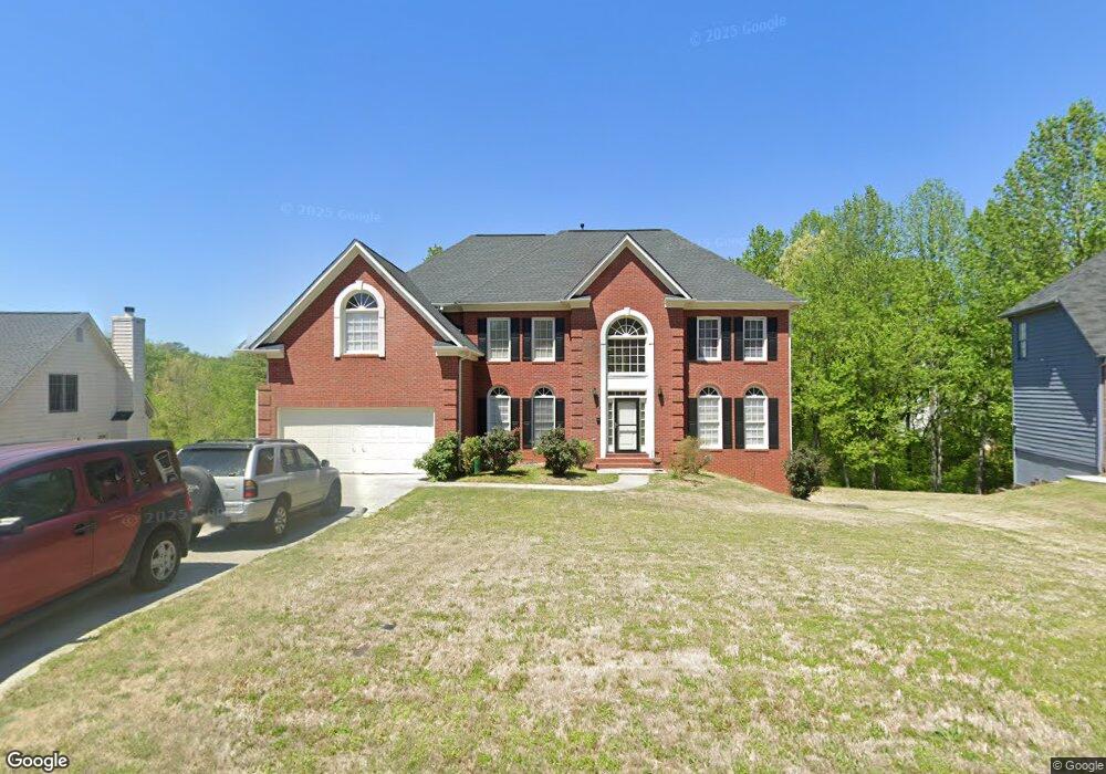
3632 River Edge Loop Decatur, GA 30034
Southwest DeKalb NeighborhoodEstimated Value: $351,000 - $383,000
4
Beds
3
Baths
2,607
Sq Ft
$140/Sq Ft
Est. Value
About This Home
This home is located at 3632 River Edge Loop, Decatur, GA 30034 and is currently estimated at $364,264, approximately $139 per square foot. 3632 River Edge Loop is a home located in DeKalb County with nearby schools including Bob Mathis Elementary School, Chapel Hill Middle School, and Southwest Dekalb High School.
Ownership History
Date
Name
Owned For
Owner Type
Purchase Details
Closed on
Apr 6, 1994
Sold by
Morrison Homes Inc
Bought by
Hale Donald A Shirley
Current Estimated Value
Home Financials for this Owner
Home Financials are based on the most recent Mortgage that was taken out on this home.
Original Mortgage
$174,250
Interest Rate
7.47%
Create a Home Valuation Report for This Property
The Home Valuation Report is an in-depth analysis detailing your home's value as well as a comparison with similar homes in the area
Home Values in the Area
Average Home Value in this Area
Purchase History
| Date | Buyer | Sale Price | Title Company |
|---|---|---|---|
| Hale Donald A Shirley | $183,000 | -- |
Source: Public Records
Mortgage History
| Date | Status | Borrower | Loan Amount |
|---|---|---|---|
| Closed | Hale Donald A Shirley | $174,250 |
Source: Public Records
Tax History
| Year | Tax Paid | Tax Assessment Tax Assessment Total Assessment is a certain percentage of the fair market value that is determined by local assessors to be the total taxable value of land and additions on the property. | Land | Improvement |
|---|---|---|---|---|
| 2025 | $4,349 | $159,840 | $19,800 | $140,040 |
| 2024 | $3,306 | $110,080 | $9,120 | $100,960 |
| 2023 | $3,306 | $133,320 | $9,120 | $124,200 |
Source: Public Records
Map
Nearby Homes
- 3801 Cherry Ridge Blvd
- 3609 River Edge Ct
- 4060 Waldrop Hills Dr
- 3562 Matthew Ct
- 4119 Waldrop Hills Dr
- 3608 Shepherds Path
- 3622 Shepherds Path Unit 3622
- 3526 Shepherds Path Unit 1
- 4137 Waldrop Hills Dr
- 3653 Woodland Cove
- 3480 Shepherds Path Unit 3480
- 3512 Patti Pkwy
- 3428 Chapel Park Dr
- 3605 Riverchase Ct
- 3604 Spring Trace
- 3816 Holy Cross Ct
- 3443 Jessica Run Unit 1
- 3740 Brown Dr
- 3778 Guilford Ct
- 3811 Holy Cross Ct Unit 2
- 3638 River Edge Loop Unit A
- 3638 River Edge Loop
- 3626 River Edge Loop
- 3620 River Edge Loop
- 3644 River Edge Loop
- 3629 River Edge Loop
- 3542 Cherry Hill Ct
- 3641 River Edge Loop
- 3652 River Edge Loop
- 3541 Cherry Hill Ct
- 3612 River Edge Loop
- 3539 Cherry Hill Ct
- 3649 River Edge Loop
- 3745 Cherry Ridge Blvd
- 3642 River Cliff Ct
- 3757 Cherry Ridge Blvd
- 3771 Cherry Ridge Blvd
- 3538 Cherry Hill Ct
- 3538 Cherry Hill Ct Unit 29
- 3604 River Edge Loop
Your Personal Tour Guide
Ask me questions while you tour the home.