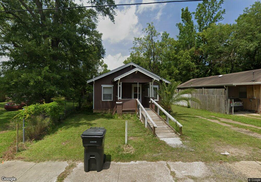
365 E Pershing St Mobile, AL 36610
East Prichard NeighborhoodEstimated Value: $37,000 - $75,000
3
Beds
1
Bath
759
Sq Ft
$69/Sq Ft
Est. Value
About This Home
This home is located at 365 E Pershing St, Mobile, AL 36610 and is currently estimated at $52,621, approximately $69 per square foot. 365 E Pershing St is a home located in Mobile County with nearby schools including Whitley Elementary School, Mobile Co Training Middle School, and Vigor High School.
Ownership History
Date
Name
Owned For
Owner Type
Purchase Details
Closed on
Mar 17, 2000
Sold by
Blanks E J E and Blanks Shirley J
Bought by
Conseco Finance Corp Alabama
Current Estimated Value
Purchase Details
Closed on
Jan 4, 1999
Sold by
Berry C M
Bought by
Blanks E J E and Blanks Shirley J
Home Financials for this Owner
Home Financials are based on the most recent Mortgage that was taken out on this home.
Original Mortgage
$14,500
Interest Rate
13.5%
Mortgage Type
Seller Take Back
Create a Home Valuation Report for This Property
The Home Valuation Report is an in-depth analysis detailing your home's value as well as a comparison with similar homes in the area
Home Values in the Area
Average Home Value in this Area
Purchase History
| Date | Buyer | Sale Price | Title Company |
|---|---|---|---|
| Conseco Finance Corp Alabama | $16,500 | -- | |
| Blanks E J E | $15,500 | -- |
Source: Public Records
Mortgage History
| Date | Status | Borrower | Loan Amount |
|---|---|---|---|
| Previous Owner | Blanks E J E | $14,500 |
Source: Public Records
Tax History
| Year | Tax Paid | Tax Assessment Tax Assessment Total Assessment is a certain percentage of the fair market value that is determined by local assessors to be the total taxable value of land and additions on the property. | Land | Improvement |
|---|---|---|---|---|
| 2025 | $225 | $3,860 | $800 | $3,060 |
| 2024 | $225 | $3,280 | $400 | $2,880 |
| 2023 | $223 | $3,620 | $480 | $3,140 |
| 2022 | $219 | $3,560 | $480 | $3,080 |
| 2021 | $216 | $3,520 | $480 | $3,040 |
| 2020 | $232 | $3,780 | $720 | $3,060 |
| 2019 | $242 | $3,940 | $720 | $3,220 |
| 2018 | $242 | $3,940 | $0 | $0 |
| 2017 | $242 | $3,940 | $0 | $0 |
| 2016 | $252 | $4,100 | $0 | $0 |
| 2013 | $236 | $3,700 | $0 | $0 |
Source: Public Records
Map
Nearby Homes
- 135 E Petain St
- 101 Diaz St
- 0 N Wilson Ave Unit 7685671
- 0 N Wilson Ave Unit 388456
- 1106 Jackson Ave
- 802 E Elm St
- 510 Iowa Ave
- 227 E Elm St
- 421 W Foch St Unit 15,16
- 421 Foch St
- 1112 Newman Ln
- 1012 Lincoln St
- 328 Glendale St
- 719 Saxon St
- 869 Edwards St
- 865 Edwards St
- 864 Grimes St
- 861 Edwards St
- 312 Lee St
- 310 Court St
- 369 E Pershing St
- 357 E Pershing St
- 373 E Pershing St
- 362 E Petain St
- 354 E Petain St
- 366 E Petain St
- 377 E Pershing St
- 351 E Pershing St
- 346 E Petain St
- 347 E Pershing St
- 352 E Pershing St
- 342 E Petain St
- 343 E Pershing St
- 361 E Petain St
- 449 Wood St
- 336 E Petain St
- 445 Wood St
- 344 E Pershing St
- 343 E Petain St
- 339 E Pershing St
Your Personal Tour Guide
Ask me questions while you tour the home.