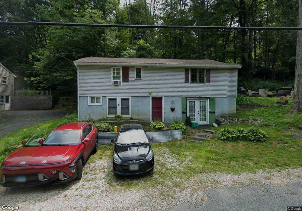
369 Salisbury Rd Canaan, CT 06018
Estimated Value: $134,000 - $269,004
3
Beds
1
Bath
1,120
Sq Ft
$198/Sq Ft
Est. Value
About This Home
This home is located at 369 Salisbury Rd, Canaan, CT 06018 and is currently estimated at $222,251, approximately $198 per square foot. 369 Salisbury Rd is a home located in Litchfield County with nearby schools including North Canaan Elementary School, Housatonic Valley Regional High School, and Salisbury School.
Ownership History
Date
Name
Owned For
Owner Type
Purchase Details
Closed on
Aug 29, 2017
Sold by
Hsbc Mortgage Services
Bought by
Tindall-Smith Amelia
Current Estimated Value
Purchase Details
Closed on
Oct 15, 1999
Sold by
Deeds John A and Bowen Robert
Bought by
Swiderski Kenneth W
Home Financials for this Owner
Home Financials are based on the most recent Mortgage that was taken out on this home.
Original Mortgage
$76,700
Interest Rate
7.8%
Create a Home Valuation Report for This Property
The Home Valuation Report is an in-depth analysis detailing your home's value as well as a comparison with similar homes in the area
Home Values in the Area
Average Home Value in this Area
Purchase History
| Date | Buyer | Sale Price | Title Company |
|---|---|---|---|
| Tindall-Smith Amelia | $15,500 | -- | |
| Swiderski Kenneth W | $77,500 | -- |
Source: Public Records
Mortgage History
| Date | Status | Borrower | Loan Amount |
|---|---|---|---|
| Previous Owner | Swiderski Kenneth W | $150,000 | |
| Previous Owner | Swiderski Kenneth W | $25,000 | |
| Previous Owner | Swiderski Kenneth W | $76,700 |
Source: Public Records
Tax History
| Year | Tax Paid | Tax Assessment Tax Assessment Total Assessment is a certain percentage of the fair market value that is determined by local assessors to be the total taxable value of land and additions on the property. | Land | Improvement |
|---|---|---|---|---|
| 2025 | $1,953 | $78,890 | $35,280 | $43,610 |
| 2024 | $1,953 | $78,890 | $35,280 | $43,610 |
| 2023 | $2,012 | $78,890 | $35,280 | $43,610 |
| 2022 | $1,716 | $55,370 | $31,400 | $23,970 |
| 2021 | $1,606 | $55,370 | $31,400 | $23,970 |
| 2020 | $1,882 | $66,630 | $31,400 | $35,230 |
| 2019 | $1,293 | $45,780 | $31,400 | $14,380 |
| 2018 | $1,259 | $45,780 | $31,400 | $14,380 |
| 2017 | $2,780 | $101,090 | $40,520 | $60,570 |
| 2016 | $2,780 | $101,090 | $40,520 | $60,570 |
| 2015 | $2,780 | $101,090 | $40,520 | $60,570 |
| 2014 | $2,780 | $101,090 | $40,520 | $60,570 |
Source: Public Records
Map
Nearby Homes
- 37 Greene Ave
- 180 Sand Rd
- 15 Honey Hill Rd
- 70 Church St Unit D1
- 100 Belden St
- 41 Prospect St
- 26 Granite Ave
- 00 N Elm St
- 354 Route 7 N
- 247 Twin Lakes Rd
- 65 E Main St
- 277 Ashley Falls Rd
- 118 Washinee Heights Rd
- 99 Washinee Heights Rd
- 143 E Canaan Rd
- 5 Prospect Mountain Rd
- 48 Preston Ln
- 9 Prospect Mountain Rd
- 89 Under Mountain Rd
- 552 Twin Lakes Rd
- 371 Salisbury Rd
- 56 Greene Ave
- 56 Greene Ave
- 373 Salisbury Rd
- 361 Salisbury Rd
- 52 Greene Ave
- 3 Terry Ln
- 377 Salisbury Rd
- 28 Housatonic Ave
- 30 Housatonic Ave
- 7 Terry Ln
- 379 Salisbury Rd
- 400 Salisbury Rd
- 350 Salisbury Rd
- 357 Salisbury Rd (Rt 44)
- 24 Housatonic Ave
- 357 Salisbury Rd
- 357 Salisbury Rd
- 7 Raymond Ave
- 32 Housatonic Ave
Your Personal Tour Guide
Ask me questions while you tour the home.