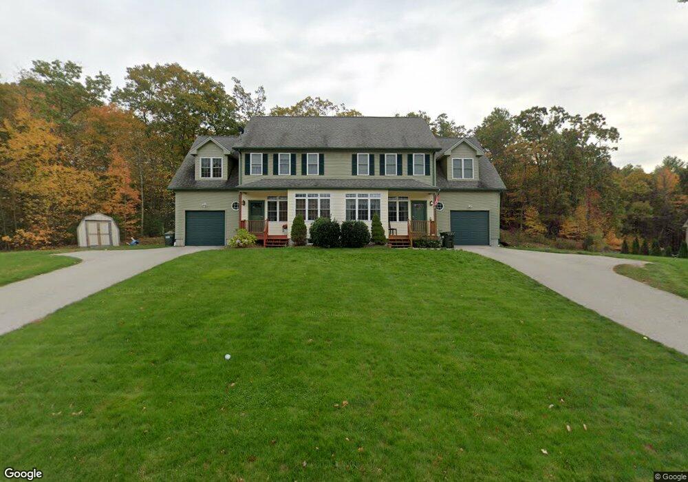
37 Sullivan Blvd Unit B Oxford, MA 01540
Estimated Value: $388,000 - $448,000
3
Beds
2
Baths
1,832
Sq Ft
$230/Sq Ft
Est. Value
About This Home
This home is located at 37 Sullivan Blvd Unit B, Oxford, MA 01540 and is currently estimated at $421,672, approximately $230 per square foot. 37 Sullivan Blvd Unit B is a home located in Worcester County with nearby schools including Alfred M Chaffee, Oxford High School, and Clara Barton Elementary School.
Ownership History
Date
Name
Owned For
Owner Type
Purchase Details
Closed on
Jun 30, 2008
Sold by
Ratcliffe Kenneth N and Ratcliffe Robin A
Bought by
Snow Adam G and Snow Kerri A
Current Estimated Value
Home Financials for this Owner
Home Financials are based on the most recent Mortgage that was taken out on this home.
Original Mortgage
$256,000
Outstanding Balance
$162,287
Interest Rate
6.07%
Mortgage Type
Purchase Money Mortgage
Estimated Equity
$259,385
Purchase Details
Closed on
Mar 15, 2007
Sold by
Wescott Llc
Bought by
Ratcliffe Kenneth N and Ratcliffe Robin A
Home Financials for this Owner
Home Financials are based on the most recent Mortgage that was taken out on this home.
Original Mortgage
$200,000
Interest Rate
6.4%
Mortgage Type
Purchase Money Mortgage
Create a Home Valuation Report for This Property
The Home Valuation Report is an in-depth analysis detailing your home's value as well as a comparison with similar homes in the area
Home Values in the Area
Average Home Value in this Area
Purchase History
| Date | Buyer | Sale Price | Title Company |
|---|---|---|---|
| Snow Adam G | $250,000 | -- | |
| Ratcliffe Kenneth N | $285,000 | -- |
Source: Public Records
Mortgage History
| Date | Status | Borrower | Loan Amount |
|---|---|---|---|
| Open | Snow Adam G | $256,000 | |
| Previous Owner | Ratcliffe Kenneth N | $200,000 |
Source: Public Records
Tax History
| Year | Tax Paid | Tax Assessment Tax Assessment Total Assessment is a certain percentage of the fair market value that is determined by local assessors to be the total taxable value of land and additions on the property. | Land | Improvement |
|---|---|---|---|---|
| 2025 | $5,115 | $403,700 | $0 | $403,700 |
| 2024 | $5,144 | $381,600 | $0 | $381,600 |
| 2023 | $4,576 | $335,500 | $0 | $335,500 |
| 2022 | $4,278 | $264,700 | $0 | $264,700 |
| 2021 | $4,375 | $264,700 | $0 | $264,700 |
| 2020 | $3,940 | $236,500 | $0 | $236,500 |
| 2019 | $3,326 | $195,300 | $0 | $195,300 |
| 2018 | $3,373 | $195,300 | $0 | $195,300 |
| 2017 | $3,100 | $184,000 | $0 | $184,000 |
| 2016 | $3,115 | $184,000 | $0 | $184,000 |
| 2015 | $2,905 | $184,000 | $0 | $184,000 |
| 2014 | $2,504 | $166,900 | $0 | $166,900 |
Source: Public Records
Map
Nearby Homes
- 0 Old Southbridge Rd
- 99 Dudley Rd
- 12 Mckinstry Dr
- 6 Carol Dr
- 63 Klondike Rd
- 196 Old Webster Rd
- 13 Harwood St
- 10 Meadowbrook Ct
- 12 Carron Ln
- 39 Fairlawn Ave
- L2 Partridge Hill Rd
- L3 Partridge Hill Rd
- 9 Howarth Rd
- 3 Howarth Rd
- 6 Marilyn Dr
- 13 Tanner Rd
- Lot 4 Daniels Rd
- Lot 3 Daniels Rd
- 4 Edward St
- 47 Main St
- 37 Sullivan Blvd Unit A
- 37 Sullivan Blvd
- 37B Sullivan Blvd
- 37B Sullivan Blvd Unit B
- 34 Sullivan Blvd
- 39 Sullivan Blvd Unit B
- 39 Sullivan Blvd Unit A
- 39 Sullivan Blvd
- 34 Sullivan Blvd Unit B
- 34 Sullivan Blvd Unit A
- 39 Sullivan Blvd
- 34B Sullivan Blvd
- 35 Sullivan Blvd
- 28 Sullivan Blvd
- 28 Sullivan Blvd Unit B
- 28 Sullivan Blvd Unit A
- 28 Sullivan Blvd Unit 1
- 30 Sullivan Blvd
- 31 Sullivan Blvd
- 33 Sullivan Blvd
Your Personal Tour Guide
Ask me questions while you tour the home.