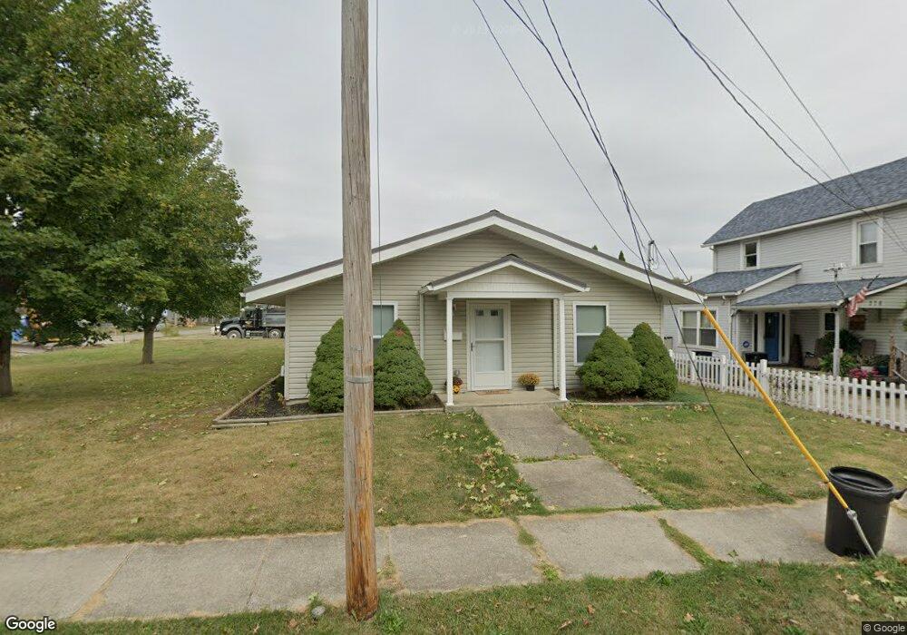
370 E Mark St Marion, OH 43302
Estimated Value: $94,000 - $135,000
3
Beds
1
Bath
1,200
Sq Ft
$92/Sq Ft
Est. Value
About This Home
This home is located at 370 E Mark St, Marion, OH 43302 and is currently estimated at $110,716, approximately $92 per square foot. 370 E Mark St is a home with nearby schools including George Washington Elementary School, Ulysses S. Grant Middle School, and Harding High School.
Ownership History
Date
Name
Owned For
Owner Type
Purchase Details
Closed on
Mar 13, 2020
Sold by
Habitat For Humanity Of Marion County Oh and Buckeye State Bank
Bought by
Millisor Victoria M
Current Estimated Value
Home Financials for this Owner
Home Financials are based on the most recent Mortgage that was taken out on this home.
Original Mortgage
$124,000
Interest Rate
5.81%
Mortgage Type
Seller Take Back
Purchase Details
Closed on
Dec 12, 2013
Sold by
The Marion Youth Devlopment Council
Bought by
Habitat For Humanity Of Marion County
Purchase Details
Closed on
Dec 9, 2013
Sold by
The City Of Marion Ohio
Bought by
Habitat For Humanity Of Marion County
Purchase Details
Closed on
Feb 3, 1999
Bought by
Habitat For Humanity Of Marion County Oh
Create a Home Valuation Report for This Property
The Home Valuation Report is an in-depth analysis detailing your home's value as well as a comparison with similar homes in the area
Home Values in the Area
Average Home Value in this Area
Purchase History
| Date | Buyer | Sale Price | Title Company |
|---|---|---|---|
| Millisor Victoria M | -- | None Listed On Document | |
| Millisor Victoria M | -- | None Listed On Document | |
| Habitat For Humanity Of Marion County | -- | None Available | |
| Habitat For Humanity Of Marion County | -- | None Available | |
| Habitat For Humanity Of Marion County Oh | -- | -- |
Source: Public Records
Mortgage History
| Date | Status | Borrower | Loan Amount |
|---|---|---|---|
| Previous Owner | Millisor Victoria M | $124,000 |
Source: Public Records
Tax History
| Year | Tax Paid | Tax Assessment Tax Assessment Total Assessment is a certain percentage of the fair market value that is determined by local assessors to be the total taxable value of land and additions on the property. | Land | Improvement |
|---|---|---|---|---|
| 2025 | $347 | $14,650 | $3,660 | $10,990 |
| 2024 | $347 | $19,020 | $3,330 | $15,690 |
| 2023 | $347 | $19,020 | $3,330 | $15,690 |
| 2022 | $678 | $19,020 | $3,330 | $15,690 |
| 2021 | $630 | $17,150 | $1,460 | $15,690 |
| 2020 | $229 | $17,150 | $1,460 | $15,690 |
| 2019 | $2 | $17,150 | $1,460 | $15,690 |
| 2018 | $2 | $16,910 | $1,390 | $15,520 |
| 2017 | $2 | $16,910 | $1,390 | $15,520 |
| 2016 | $2 | $16,910 | $1,390 | $15,520 |
| 2015 | $2 | $16,910 | $1,390 | $15,520 |
| 2014 | $2 | $16,910 | $1,390 | $15,520 |
| 2012 | $2 | $17,140 | $970 | $16,170 |
Source: Public Records
Map
Nearby Homes
- 393 E George St
- 212 Short St
- 434 N State St
- 279 E Fairground St
- 516 Polk St
- 531 N Main St
- 438 N Prospect St Unit 434
- 532 N Prospect St
- 197 Harrison St
- 552 N Prospect St
- 389 Oak St
- 716 N Main St
- 233 Tully St
- 250 N Grand Ave
- 537 Fair Park Ave
- 384 Mary St
- 525 Oak St
- 736 N Main St
- 506 Mary St Unit 508
- 569 E Church St
Your Personal Tour Guide
Ask me questions while you tour the home.