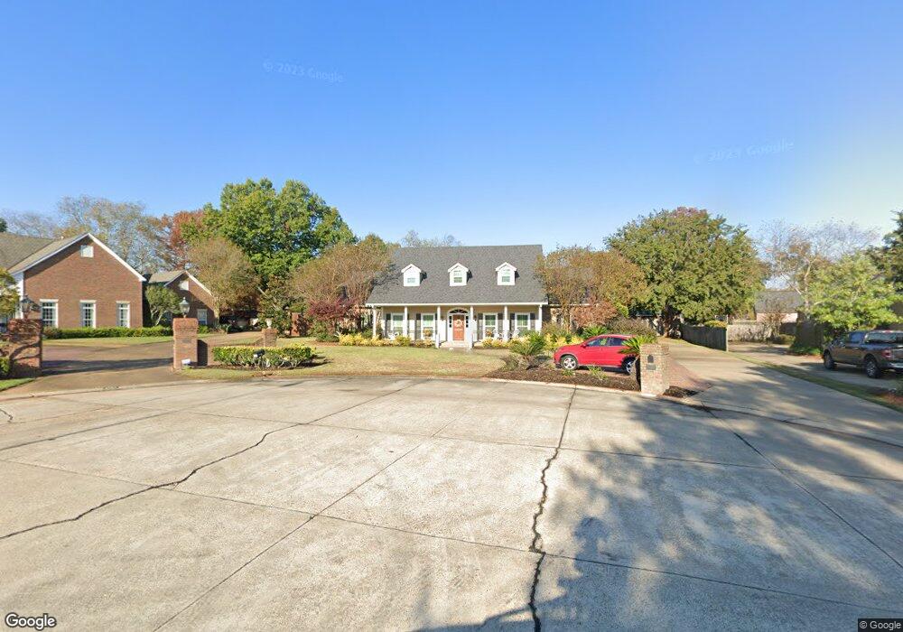
3705 Bayside Cir Monroe, LA 71201
North Monroe NeighborhoodEstimated Value: $565,000 - $616,000
4
Beds
4
Baths
4,619
Sq Ft
$128/Sq Ft
Est. Value
About This Home
This home is located at 3705 Bayside Cir, Monroe, LA 71201 and is currently estimated at $592,555, approximately $128 per square foot. 3705 Bayside Cir is a home located in Ouachita Parish with nearby schools including Lexington Elementary School, Sallie Humble Elementary School, and Neville Junior High School.
Ownership History
Date
Name
Owned For
Owner Type
Purchase Details
Closed on
Dec 30, 2008
Sold by
Feder Scott Frederick and Feder Elena Tenorio
Bought by
Dewitt Gareld Eugene and Dewitt Christina Booth
Current Estimated Value
Home Financials for this Owner
Home Financials are based on the most recent Mortgage that was taken out on this home.
Original Mortgage
$384,759
Interest Rate
5.5%
Mortgage Type
Purchase Money Mortgage
Create a Home Valuation Report for This Property
The Home Valuation Report is an in-depth analysis detailing your home's value as well as a comparison with similar homes in the area
Home Values in the Area
Average Home Value in this Area
Purchase History
We collect this data history from publicly available records. To have your information removed, we recommend requesting removal directly through your county’s website.
| Date | Buyer | Sale Price | Title Company |
|---|---|---|---|
| Dewitt Gareld Eugene | $382,000 | North Delta Title & Abstra |
Source: Public Records
Mortgage History
We collect this data history from publicly available records. To have your information removed, we recommend requesting removal directly through your county’s website.
| Date | Status | Borrower | Loan Amount |
|---|---|---|---|
| Closed | Dewitt Gareld Eugene | $384,759 |
Source: Public Records
Tax History
| Year | Tax Paid | Tax Assessment Tax Assessment Total Assessment is a certain percentage of the fair market value that is determined by local assessors to be the total taxable value of land and additions on the property. | Land | Improvement |
|---|---|---|---|---|
| 2025 | $5,326 | $54,652 | $10,429 | $44,223 |
| 2024 | $5,326 | $54,652 | $10,429 | $44,223 |
| 2023 | $5,330 | $48,571 | $10,429 | $38,142 |
| 2022 | $5,139 | $48,571 | $10,429 | $38,142 |
| 2021 | $5,127 | $48,571 | $10,429 | $38,142 |
| 2020 | $5,127 | $48,571 | $10,429 | $38,142 |
| 2019 | $5,287 | $50,397 | $13,037 | $37,360 |
| 2018 | $4,709 | $50,397 | $13,037 | $37,360 |
| 2017 | $4,877 | $44,053 | $10,429 | $33,624 |
| 2016 | $3,822 | $38,200 | $14,606 | $23,594 |
| 2015 | $3,591 | $38,200 | $14,606 | $23,594 |
| 2014 | $3,591 | $38,200 | $14,606 | $23,594 |
| 2013 | $3,582 | $38,200 | $14,606 | $23,594 |
Source: Public Records
Map
Nearby Homes
- 3408 W Deborah Dr
- 2743 Point Dr
- 3105 W Deborah Dr
- 3004 John Cole Place
- 3919 Jefferson Davis Dr
- 3915 Jefferson Davis Dr
- 2718 Point Dr
- 3313 Deborah Dr
- 2704 Oak Dr
- 3309 Beauvoir Place
- 3409 Loop Rd
- 3380 Deborah Dr
- 3400 Deborah Dr
- 2318 Whitney Dr
- 3607 Kates Way
- 3605 Deborah Dr
- 709 Joseph St
- 2315 Duval Dr
- 3701 Deborah Dr
- 2609 Bonita Place
- 3701 Bayside Cir
- 3709 Bayside Cir
- 3212 Deborah Dr
- 3220 Deborah Dr
- 3208 Deborah Dr
- 3216 Deborah Dr
- 3713 Bayside Cir
- 3224 Deborah Dr
- 3712 Bayside Cir
- 3204 Deborah Dr
- 3700 Bayside Cir
- 3211 Deborah Dr
- 3714 Bayside Cir
- 3221 Deborah Dr
- 3228 Deborah Dr
- 3717 Bayside Cir
- 3612 Cole Landing Dr
- 3404 W Deborah Dr
- 3606 Cole Landing Dr
- 3200 Deborah Dr
Your Personal Tour Guide
Ask me questions while you tour the home.