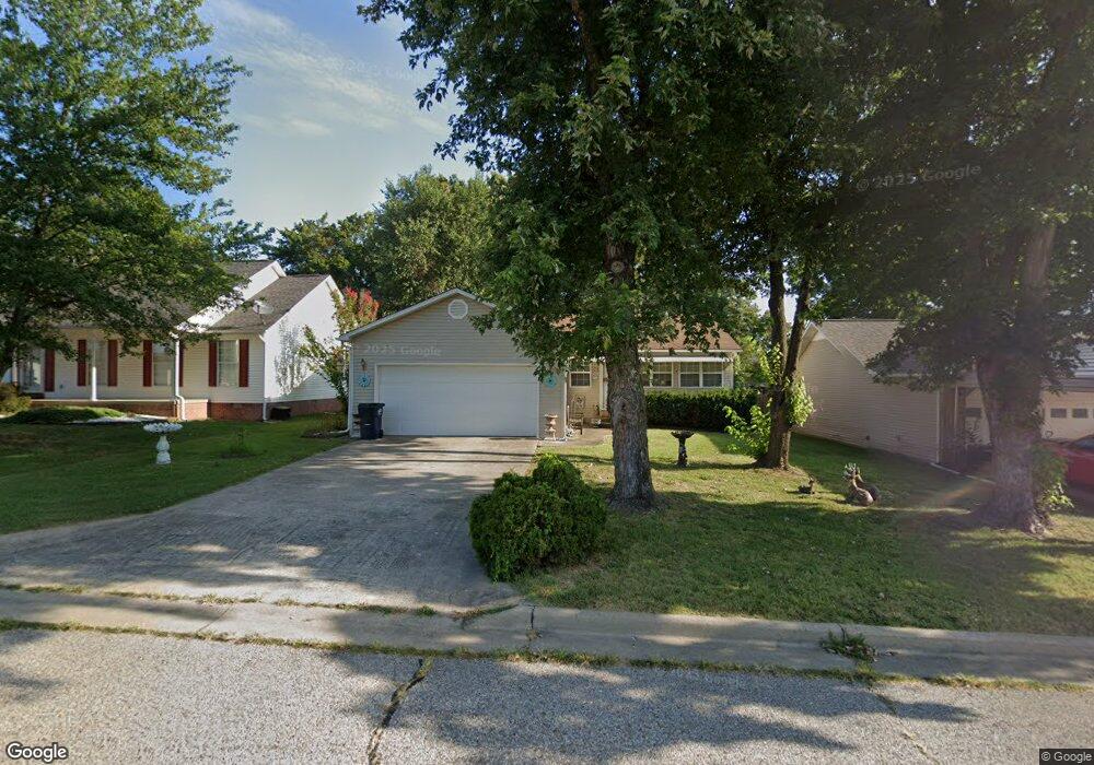
3707 Shields Dr Harrison, AR 72601
Estimated Value: $148,699 - $183,000
3
Beds
2
Baths
1,247
Sq Ft
$137/Sq Ft
Est. Value
About This Home
This home is located at 3707 Shields Dr, Harrison, AR 72601 and is currently estimated at $170,425, approximately $136 per square foot. 3707 Shields Dr is a home located in Boone County with nearby schools including Skyline Heights Elementary School, Harrison Jr. High School, and Harrison High School.
Ownership History
Date
Name
Owned For
Owner Type
Purchase Details
Closed on
Apr 21, 2022
Sold by
Whited Rita Darlene
Bought by
Whited Rita Darlene and Perme Cindy
Current Estimated Value
Purchase Details
Closed on
Feb 14, 2005
Sold by
Whited Michael and Whited Sandy K
Bought by
Whited Rita Darlene and Hahn Cindy
Purchase Details
Closed on
Jul 21, 2003
Sold by
Whited Coyeta and Whited Michael
Bought by
Whited Coyeta and Whited Michael
Purchase Details
Closed on
Jun 20, 2001
Bought by
Whited
Purchase Details
Closed on
Jun 18, 2001
Bought by
Whited and Whited
Create a Home Valuation Report for This Property
The Home Valuation Report is an in-depth analysis detailing your home's value as well as a comparison with similar homes in the area
Purchase History
| Date | Buyer | Sale Price | Title Company |
|---|---|---|---|
| Whited Rita Darlene | -- | None Listed On Document | |
| Whited Rita Darlene | -- | None Available | |
| Whited Coyeta | -- | Boone County Abstract & Titl | |
| Whited | $73,000 | -- | |
| Whited | -- | -- |
Source: Public Records
Tax History
| Year | Tax Paid | Tax Assessment Tax Assessment Total Assessment is a certain percentage of the fair market value that is determined by local assessors to be the total taxable value of land and additions on the property. | Land | Improvement |
|---|---|---|---|---|
| 2025 | $846 | $20,700 | $2,000 | $18,700 |
| 2024 | $846 | $20,700 | $2,000 | $18,700 |
| 2023 | $846 | $20,700 | $2,000 | $18,700 |
| 2022 | $471 | $20,700 | $2,000 | $18,700 |
| 2021 | $471 | $20,700 | $2,000 | $18,700 |
| 2020 | $471 | $17,750 | $2,000 | $15,750 |
| 2019 | $489 | $17,750 | $2,000 | $15,750 |
| 2018 | $514 | $17,750 | $2,000 | $15,750 |
| 2017 | $846 | $17,750 | $2,000 | $15,750 |
| 2016 | $496 | $16,590 | $2,000 | $14,590 |
| 2015 | $846 | $16,590 | $2,000 | $14,590 |
| 2014 | $496 | $16,590 | $2,000 | $14,590 |
Source: Public Records
Map
Nearby Homes
- 3607 W Overland Cir
- 1800 Airport Rd
- 0 Gipson Rd
- 602 Oriole Dr
- 203 Glenview St
- 307 Prestonwood St
- 26 Ozark Dr
- Lot 3 Cornerstone Way
- Lot 1 Cornerstone Way
- Lot 4 Cornerstone Way
- Lot 2 Cornerstone Way
- Lot 1 Rains Rd S
- Lot 2 Rains Rd S
- 0 Corner of Airport Rd & Hwy 65n Unit 146774
- 107 Nancy St
- 0 Arkansas 397
- 3113 Savannah Dr
- Lot 3 Hawkins Rd
- Lot 4 Hawkins Rd
- Lot 5 Hawkins Rd
- 3705 Shields Dr
- 3801 Shields Dr
- 3702 W Hill Ave
- 3704 W Hill Ave
- 3703 Shields Dr
- 3708 Shields Dr
- 3803 Shields Dr
- 3706 Shields Dr
- 3804 Shields Dr
- 3708 W Hill Ave
- 3706 W Hill Ave
- 3704 Shields Dr
- 3701 Shields Dr
- 3614 W Hill Ave
- 3806 Shields Dr
- 3702 Shields Dr
- 3615 Shields Dr
- 3807 Shields Dr
- 3612 W Hill Ave
- 3700 W Hill Ave
Your Personal Tour Guide
Ask me questions while you tour the home.