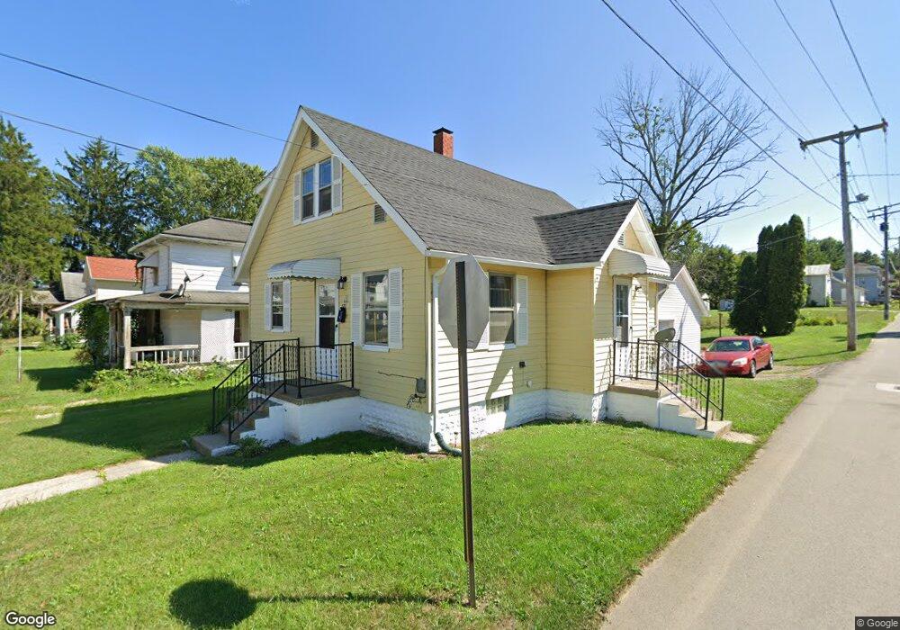
371 W 6th St Mansfield, OH 44903
Estimated Value: $61,000 - $76,541
3
Beds
2
Baths
1,275
Sq Ft
$53/Sq Ft
Est. Value
About This Home
This home is located at 371 W 6th St, Mansfield, OH 44903 and is currently estimated at $67,385, approximately $52 per square foot. 371 W 6th St is a home located in Richland County with nearby schools including Goal Digital Academy, St. Peter's Elementary/Montessori School, and St. Peter's Junior High / High School.
Ownership History
Date
Name
Owned For
Owner Type
Purchase Details
Closed on
May 15, 2021
Sold by
Rental Properties Llc
Bought by
Jrm Properties Of Mansfield Llc
Current Estimated Value
Purchase Details
Closed on
Mar 22, 2017
Sold by
Sevson Properties Llc
Bought by
Tat Rental Properties Llc
Home Financials for this Owner
Home Financials are based on the most recent Mortgage that was taken out on this home.
Original Mortgage
$77,000
Interest Rate
4.17%
Mortgage Type
Commercial
Purchase Details
Closed on
Jan 3, 2013
Sold by
Cole Donald G
Bought by
Sevson Properties Llc
Purchase Details
Closed on
Mar 30, 2009
Sold by
Cole Kenneth E and Cole Karen E
Bought by
Cole Donald G
Home Financials for this Owner
Home Financials are based on the most recent Mortgage that was taken out on this home.
Original Mortgage
$11,102
Interest Rate
5.22%
Mortgage Type
Future Advance Clause Open End Mortgage
Purchase Details
Closed on
Feb 12, 1993
Sold by
Martin William A
Bought by
Martin Gurtha L
Create a Home Valuation Report for This Property
The Home Valuation Report is an in-depth analysis detailing your home's value as well as a comparison with similar homes in the area
Home Values in the Area
Average Home Value in this Area
Purchase History
| Date | Buyer | Sale Price | Title Company |
|---|---|---|---|
| Jrm Properties Of Mansfield Llc | $139,000 | Southern Title | |
| Tat Rental Properties Llc | $77,000 | Attorney | |
| Sevson Properties Llc | $10,000 | None Available | |
| Cole Donald G | $9,950 | Chicago Title | |
| Martin Gurtha L | -- | -- |
Source: Public Records
Mortgage History
| Date | Status | Borrower | Loan Amount |
|---|---|---|---|
| Previous Owner | Tat Rental Properties Llc | $77,000 | |
| Previous Owner | Cole Donald G | $11,102 |
Source: Public Records
Tax History
| Year | Tax Paid | Tax Assessment Tax Assessment Total Assessment is a certain percentage of the fair market value that is determined by local assessors to be the total taxable value of land and additions on the property. | Land | Improvement |
|---|---|---|---|---|
| 2025 | $346 | $7,220 | $1,020 | $6,200 |
| 2024 | $346 | $7,220 | $1,020 | $6,200 |
| 2023 | $346 | $7,220 | $1,020 | $6,200 |
| 2022 | $405 | $7,090 | $1,190 | $5,900 |
| 2021 | $408 | $7,090 | $1,190 | $5,900 |
| 2020 | $417 | $7,090 | $1,190 | $5,900 |
| 2019 | $462 | $7,090 | $1,190 | $5,900 |
| 2018 | $456 | $7,090 | $1,190 | $5,900 |
| 2017 | $386 | $7,090 | $1,190 | $5,900 |
| 2016 | $409 | $6,330 | $1,190 | $5,140 |
| 2015 | $390 | $6,330 | $1,190 | $5,140 |
| 2014 | $513 | $8,420 | $1,190 | $7,230 |
| 2012 | $393 | $8,420 | $1,190 | $7,230 |
Source: Public Records
Map
Nearby Homes
- 368 W 6th St
- 344 W 5th St
- 447 Spayer Ln
- 224 Atcheson Ave
- 219 W 5th St
- 458 W West Dickson Ave
- 453 W Dickson Ave
- 245 W 4th St
- 509 Heineman Blvd
- 519 Heineman Blvd
- 38 Penn Ave
- 375 Mcpherson St
- 30 Douglas Ave
- 51 Lind Ave
- 157 Marion Ave
- 0 Lemley Ave Unit 9070540
- 0 State Route 314 Unit 9069650
- 135 Wood St
- 688 Mcpherson St
- 524 Lida St
Your Personal Tour Guide
Ask me questions while you tour the home.