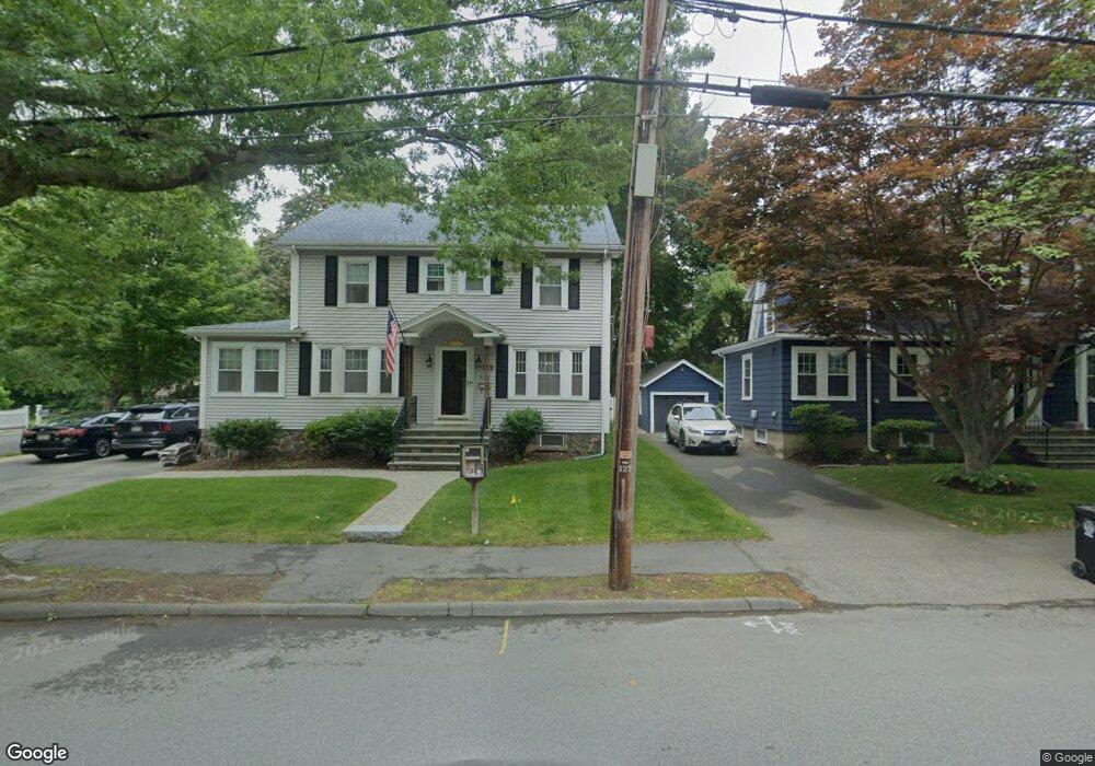
377 Forest Ave Swampscott, MA 01907
Estimated Value: $810,335 - $906,000
4
Beds
2
Baths
1,944
Sq Ft
$446/Sq Ft
Est. Value
About This Home
This home is located at 377 Forest Ave, Swampscott, MA 01907 and is currently estimated at $867,334, approximately $446 per square foot. 377 Forest Ave is a home located in Essex County with nearby schools including Swampscott Middle School and Swampscott High School.
Ownership History
Date
Name
Owned For
Owner Type
Purchase Details
Closed on
Jan 12, 2017
Sold by
Barden Marc E and Barden Lisa F
Bought by
377 Forest Avenue Rt and Barden
Current Estimated Value
Create a Home Valuation Report for This Property
The Home Valuation Report is an in-depth analysis detailing your home's value as well as a comparison with similar homes in the area
Home Values in the Area
Average Home Value in this Area
Purchase History
We collect this data history from publicly available records. To have your information removed, we recommend requesting removal directly through your county’s website.
| Date | Buyer | Sale Price | Title Company |
|---|---|---|---|
| 377 Forest Avenue Rt | -- | -- |
Source: Public Records
Tax History
| Year | Tax Paid | Tax Assessment Tax Assessment Total Assessment is a certain percentage of the fair market value that is determined by local assessors to be the total taxable value of land and additions on the property. | Land | Improvement |
|---|---|---|---|---|
| 2025 | $8,013 | $698,600 | $296,300 | $402,300 |
| 2024 | $7,797 | $678,600 | $283,000 | $395,600 |
| 2023 | $7,377 | $628,400 | $265,400 | $363,000 |
| 2022 | $6,989 | $544,700 | $230,000 | $314,700 |
| 2021 | $6,756 | $489,600 | $203,400 | $286,200 |
| 2020 | $6,875 | $480,800 | $199,000 | $281,800 |
| 2019 | $6,569 | $432,200 | $150,400 | $281,800 |
| 2018 | $6,667 | $416,700 | $145,900 | $270,800 |
| 2017 | $6,966 | $399,200 | $145,900 | $253,300 |
| 2016 | $6,918 | $399,200 | $145,900 | $253,300 |
| 2015 | $6,846 | $399,200 | $145,900 | $253,300 |
| 2014 | $6,738 | $360,300 | $141,500 | $218,800 |
Source: Public Records
Map
Nearby Homes
- 5 Lexington Park
- 9 Sheridan Rd
- 481 Humphrey St
- 53 Puritan Rd
- 49 Ocean View Rd
- 90 Puritan Rd
- 6 Elmwood Rd
- 2 Ellis Terrace
- 143 Burrill St Unit 301
- 187 Burrill St Unit 2
- 104-106 Burrill St
- 28 Claremont Terrace Unit 6
- 31 Lincoln House Point
- 11 Boynton St Unit 101
- 11 Boynton St Unit 202
- 404 Paradise Rd Unit 1D
- 404 Paradise Rd Unit 1C
- 24 Muriel Rd
- 251 Puritan Rd
- 77 Shelton Rd
- 373 Forest Ave
- 385 Forest Ave
- 367 Forest Ave
- 4 Supreme Ct
- 389 Forest Ave
- 378 Forest Ave
- 363 Forest Ave
- 92 Fuller Ave
- 359 Forest Ave
- 182 Redington St
- 374 Forest Ave
- 1 Supreme Ct
- 87 Fuller Ave
- 6 Supreme Ct
- 8 Brooks Terrace
- 127 Greenwood Ave
- 2 Brooks Terrace
- 178 Redington St
- 12 Brooks Terrace
- 15 Sherwood Rd
Your Personal Tour Guide
Ask me questions while you tour the home.