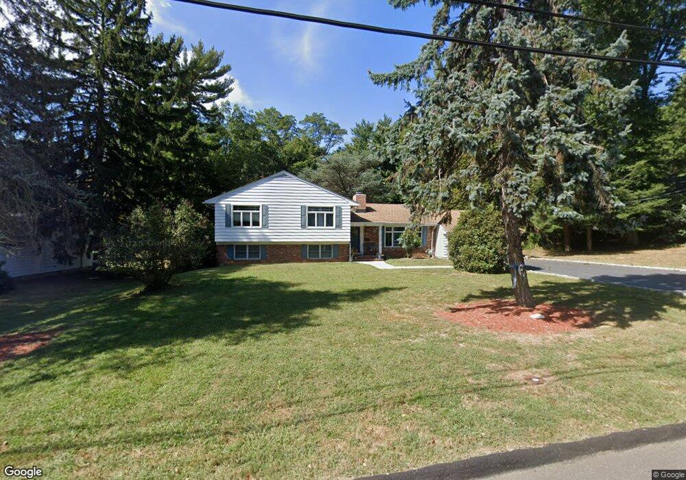
38 The Trail Middletown, NJ 07748
New Monmouth NeighborhoodEstimated Value: $893,175 - $983,000
--
Bed
3
Baths
2,580
Sq Ft
$370/Sq Ft
Est. Value
About This Home
This home is located at 38 The Trail, Middletown, NJ 07748 and is currently estimated at $954,544, approximately $369 per square foot. 38 The Trail is a home located in Monmouth County with nearby schools including Middletown Village Elementary School, Thompson Middle School, and Middletown High School North.
Ownership History
Date
Name
Owned For
Owner Type
Purchase Details
Closed on
May 24, 2010
Sold by
Carey Wayne A and Carey Ninette
Bought by
Carey Ninette
Current Estimated Value
Purchase Details
Closed on
Oct 22, 1999
Sold by
Drescher Genevieve
Bought by
Carey Wayne and Carey Ninette
Home Financials for this Owner
Home Financials are based on the most recent Mortgage that was taken out on this home.
Original Mortgage
$240,000
Outstanding Balance
$72,134
Interest Rate
7.77%
Estimated Equity
$882,410
Create a Home Valuation Report for This Property
The Home Valuation Report is an in-depth analysis detailing your home's value as well as a comparison with similar homes in the area
Home Values in the Area
Average Home Value in this Area
Purchase History
| Date | Buyer | Sale Price | Title Company |
|---|---|---|---|
| Carey Ninette | -- | None Available | |
| Carey Wayne | $335,875 | -- |
Source: Public Records
Mortgage History
| Date | Status | Borrower | Loan Amount |
|---|---|---|---|
| Open | Carey Wayne | $240,000 |
Source: Public Records
Tax History
| Year | Tax Paid | Tax Assessment Tax Assessment Total Assessment is a certain percentage of the fair market value that is determined by local assessors to be the total taxable value of land and additions on the property. | Land | Improvement |
|---|---|---|---|---|
| 2025 | $11,448 | $701,900 | $372,500 | $329,400 |
| 2024 | $10,640 | $695,900 | $372,500 | $323,400 |
| 2023 | $10,640 | $612,200 | $339,400 | $272,800 |
| 2022 | $10,452 | $586,700 | $322,800 | $263,900 |
| 2021 | $10,452 | $541,000 | $306,300 | $234,700 |
| 2020 | $11,413 | $533,800 | $304,400 | $229,400 |
| 2019 | $11,246 | $532,500 | $304,400 | $228,100 |
| 2018 | $11,652 | $537,700 | $304,400 | $233,300 |
| 2017 | $10,779 | $507,500 | $281,300 | $226,200 |
| 2016 | $10,693 | $501,800 | $281,300 | $220,500 |
| 2015 | $10,689 | $500,400 | $281,300 | $219,100 |
| 2014 | $10,542 | $481,600 | $281,300 | $200,300 |
Source: Public Records
Map
Nearby Homes
- 4 the Lenape Trail
- 63 Pate Dr
- 27 Pate Dr
- 34 Southview Terrace S
- 62 Cypress Neck Rd
- 4 Packard Dr
- 164 Heights Terrace
- 58 Foxwood Run Unit Run
- 4 Del Ray Ct
- 7 Shire Way
- 13 Arthur Place
- 111 Heights Terrace
- 44 Tall Tree Rd
- 44 Bunker Hill Dr
- 35 Woodland Dr
- 77 Bunker Hill Dr
- 1 Gary Dr
- 33 Swartzel Dr
- 37 Swartzel Dr
- 1901 Evans Ln
Your Personal Tour Guide
Ask me questions while you tour the home.