Estimated Value: $285,378 - $364,000
2
Beds
1
Bath
1,890
Sq Ft
$169/Sq Ft
Est. Value
About This Home
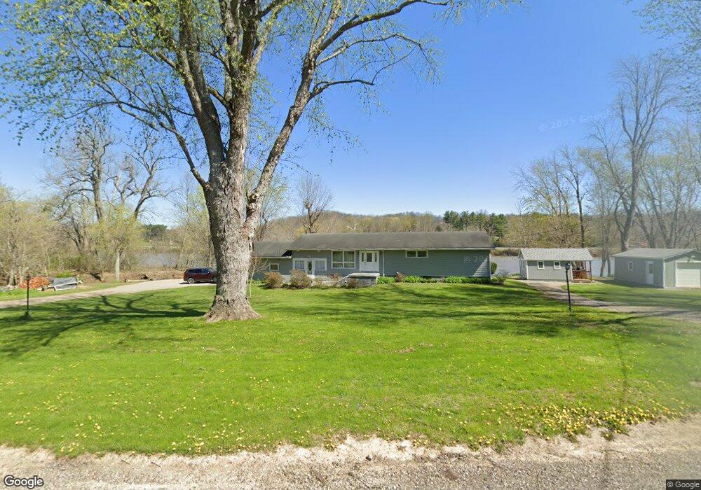
This home is located at 3810 Old River Rd, Philo, OH 43771 and is currently estimated at $318,845, approximately $168 per square foot. 3810 Old River Rd is a home located in Muskingum County with nearby schools including Philo High School and Zanesville Community School.
Ownership History
Date
Name
Owned For
Owner Type
Purchase Details
Closed on
Feb 25, 2016
Bought by
Thomas E Durst and B Bernice
Current Estimated Value
Home Financials for this Owner
Home Financials are based on the most recent Mortgage that was taken out on this home.
Interest Rate
3.62%
Purchase Details
Closed on
Jun 28, 2005
Sold by
Walters Johnnie
Bought by
Bateman Christopher and Bateman Christopher T
Home Financials for this Owner
Home Financials are based on the most recent Mortgage that was taken out on this home.
Original Mortgage
$63,535
Interest Rate
5.68%
Mortgage Type
Fannie Mae Freddie Mac
Purchase Details
Closed on
Jul 28, 1992
Bought by
Walters Ii Johnnie
Create a Home Valuation Report for This Property
The Home Valuation Report is an in-depth analysis detailing your home's value as well as a comparison with similar homes in the area
Purchase History
| Date | Buyer | Sale Price | Title Company |
|---|---|---|---|
| Thomas E Durst | $72,000 | -- | |
| Bateman Christopher | $65,500 | -- | |
| Walters Ii Johnnie | -- | -- |
Source: Public Records
Mortgage History
| Date | Status | Borrower | Loan Amount |
|---|---|---|---|
| Previous Owner | Thomas E Durst | -- | |
| Previous Owner | Bateman Christopher | $63,535 |
Source: Public Records
Tax History
| Year | Tax Paid | Tax Assessment Tax Assessment Total Assessment is a certain percentage of the fair market value that is determined by local assessors to be the total taxable value of land and additions on the property. | Land | Improvement |
|---|---|---|---|---|
| 2025 | $3,721 | $66,745 | $20,160 | $46,585 |
| 2024 | $2,110 | $66,745 | $20,160 | $46,585 |
| 2023 | $1,431 | $42,910 | $14,875 | $28,035 |
| 2022 | $1,393 | $42,910 | $14,875 | $28,035 |
| 2021 | $1,370 | $42,910 | $14,875 | $28,035 |
| 2020 | $1,268 | $39,025 | $13,545 | $25,480 |
| 2019 | $1,265 | $39,025 | $13,545 | $25,480 |
| 2018 | $1,295 | $39,025 | $13,545 | $25,480 |
| 2017 | $1,220 | $34,720 | $13,545 | $21,175 |
| 2016 | $1,178 | $34,730 | $13,550 | $21,180 |
| 2015 | $1,210 | $34,730 | $13,550 | $21,180 |
| 2013 | $1,303 | $34,730 | $13,550 | $21,180 |
Source: Public Records
Map
Nearby Homes
- 0 Sealover Hollow Rd
- 4145 Old River Rd
- 3345 Durant Rd
- 3100 Durant Rd
- 1685 Fattler Ridge Rd
- 2519 Frick Dr
- 2654 Darlington Dr
- 1085 Walter Dr
- 27 Marshdale Rd
- 2656 Darlington Dr
- 3800 E Darlington Rd
- 3060 Wayne Ridge Rd
- 97 E King St
- 512 North St
- 44 Kensington Ave
- 535 Wheeler Dr
- 20 Juanita Dr
- 67 E King St
- 2435 Freedom Ln
- 71 E Berkley St
- 3730 S River Rd
- 3740 S River Rd
- 3915 Old River Rd
- 3660 S River Rd
- 3913 Old River Rd
- 3734 S River Rd
- 3959 Old River Rd
- 3960 Old River Rd
- 3963 Old River Rd
- 3963 Old River Rd
- 3967 Old River Rd
- 3985 Old River Rd
- 3496 S River Rd
- 3590 Center Rd
- 3505 Center Rd
- 3555 Old River Rd
- 3490 S River Rd
- 3545 Old River Rd
- 3525 Old River Rd
- 3495 Old River Rd
Your Personal Tour Guide
Ask me questions while you tour the home.