Estimated Value: $253,000
3
Beds
2
Baths
966
Sq Ft
$262/Sq Ft
Est. Value
About This Home
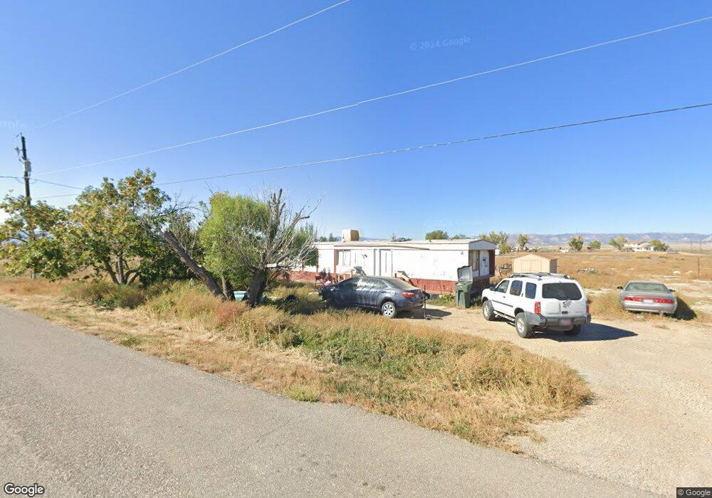
This home is located at 3845 E 6875 S, Price, UT 84501 and is currently estimated at $253,000, approximately $261 per square foot. 3845 E 6875 S is a home located in Carbon County with nearby schools including Creekview School, Mont Harmon Junior High School, and Carbon High School.
Ownership History
Date
Name
Owned For
Owner Type
Purchase Details
Closed on
Mar 23, 2015
Sold by
Naylor John L and Naylor Barbara J
Bought by
Cullison Phillip and Moyes Tiffany
Current Estimated Value
Purchase Details
Closed on
Feb 18, 2014
Sold by
Dye Richard Allen
Bought by
Naylor John L and Naylor Barbara J
Purchase Details
Closed on
Nov 2, 2012
Sold by
Naylor John L and Naylor Barbara J
Bought by
Dye Richard Allen
Home Financials for this Owner
Home Financials are based on the most recent Mortgage that was taken out on this home.
Original Mortgage
$27,200
Interest Rate
3.33%
Mortgage Type
Purchase Money Mortgage
Purchase Details
Closed on
Apr 3, 2012
Sold by
Naylor John L
Bought by
Naylor John L and Naylor Barbara J
Create a Home Valuation Report for This Property
The Home Valuation Report is an in-depth analysis detailing your home's value as well as a comparison with similar homes in the area
Purchase History
| Date | Buyer | Sale Price | Title Company |
|---|---|---|---|
| Cullison Phillip | -- | None Available | |
| Naylor John L | $27,990 | South Eastern Utah Title Co | |
| Dye Richard Allen | -- | South Eastern Utah Title Co | |
| Naylor John L | -- | None Available |
Source: Public Records
Mortgage History
| Date | Status | Borrower | Loan Amount |
|---|---|---|---|
| Previous Owner | Dye Richard Allen | $27,200 |
Source: Public Records
Tax History
| Year | Tax Paid | Tax Assessment Tax Assessment Total Assessment is a certain percentage of the fair market value that is determined by local assessors to be the total taxable value of land and additions on the property. | Land | Improvement |
|---|---|---|---|---|
| 2025 | $804 | $92,000 | $88,400 | $3,600 |
| 2024 | $1,021 | $62,098 | $52,635 | $9,463 |
| 2023 | $727 | $49,546 | $42,573 | $6,973 |
| 2022 | $519 | $34,020 | $27,047 | $6,973 |
| 2021 | $480 | $49,882 | $39,658 | $10,224 |
| 2020 | $427 | $25,560 | $0 | $0 |
| 2019 | $341 | $25,003 | $0 | $0 |
| 2018 | $332 | $28,711 | $0 | $0 |
| 2017 | $274 | $20,970 | $0 | $0 |
| 2016 | $245 | $20,970 | $0 | $0 |
| 2015 | $245 | $20,970 | $0 | $0 |
| 2014 | $259 | $22,470 | $0 | $0 |
| 2013 | $263 | $22,630 | $0 | $0 |
Source: Public Records
Map
Nearby Homes
- 7250 S Hanley Ln Unit LotWP001
- 7250 S Hanley Ln
- 3367 E 4750 S
- 446 Riverside Dr Unit 24
- 0 Riverside Dr Unit 42
- 418 S 100 E
- 106 E Richelman Ln
- 140 S 600 E
- 102 W 250 S
- 631 W Main St
- 704 E Pine St
- 750 E Pine St
- 760 E Pine St
- 150 S 500 E
- 710 E Ash St
- 496 E Main St
- 55 200 E
- 510 W Highway Dr
- 797 E Maple St
- 36 E 200 N
- 3804 E 6875 S
- 3844 E 6875 S
- 3777 E 6875 S Unit 33
- 3778 E 6875 S Unit 32
- 3896 E 6875 S Unit 43
- 3890 E 6750 S
- 3710 E 6875 S
- 3871 E 6750 S
- 3795 E 6750 S
- 3805 E 6750 S
- 6906 S 4000 E
- 6906 S 4000 E
- 3909 E 6750 S
- 3843 E 6750 S
- 3937 E 6750 S
- 3624 E 6875 S
- 6835 S 4000 E Unit 5
- 6865 S 4000 E Unit 7
- 3675 E 6750 S
- 6976 S 4000 E
Your Personal Tour Guide
Ask me questions while you tour the home.