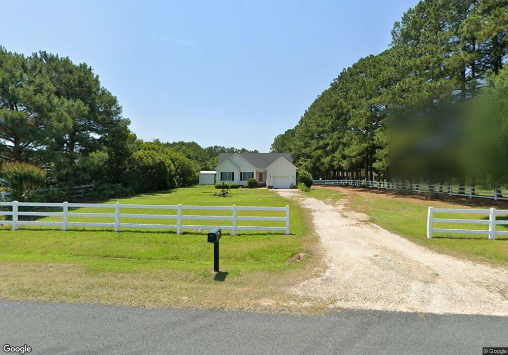
385 Ennis Rd Angier, NC 27501
Estimated Value: $261,404 - $314,000
3
Beds
2
Baths
1,458
Sq Ft
$196/Sq Ft
Est. Value
About This Home
This home is located at 385 Ennis Rd, Angier, NC 27501 and is currently estimated at $285,101, approximately $195 per square foot. 385 Ennis Rd is a home located in Harnett County with nearby schools including Angier Elementary School, North Harnett Primary School, and Harnett Central Middle School.
Ownership History
Date
Name
Owned For
Owner Type
Purchase Details
Closed on
Jul 12, 2012
Sold by
Orr John Morriosn and Orr Baonnie Lou
Bought by
Pearce Johnny E
Current Estimated Value
Home Financials for this Owner
Home Financials are based on the most recent Mortgage that was taken out on this home.
Original Mortgage
$127,000
Outstanding Balance
$92,014
Interest Rate
4.75%
Mortgage Type
Stand Alone Second
Estimated Equity
$193,087
Create a Home Valuation Report for This Property
The Home Valuation Report is an in-depth analysis detailing your home's value as well as a comparison with similar homes in the area
Home Values in the Area
Average Home Value in this Area
Purchase History
| Date | Buyer | Sale Price | Title Company |
|---|---|---|---|
| Pearce Johnny E | $127,000 | None Available |
Source: Public Records
Mortgage History
| Date | Status | Borrower | Loan Amount |
|---|---|---|---|
| Open | Pearce Johnny E | $127,000 |
Source: Public Records
Tax History
| Year | Tax Paid | Tax Assessment Tax Assessment Total Assessment is a certain percentage of the fair market value that is determined by local assessors to be the total taxable value of land and additions on the property. | Land | Improvement |
|---|---|---|---|---|
| 2025 | $1,442 | $200,797 | $0 | $0 |
| 2024 | $1,442 | $200,797 | $0 | $0 |
| 2023 | $1,422 | $200,797 | $0 | $0 |
| 2022 | $1,179 | $200,797 | $0 | $0 |
| 2021 | $1,179 | $133,400 | $0 | $0 |
| 2020 | $1,179 | $133,400 | $0 | $0 |
| 2019 | $1,164 | $133,400 | $0 | $0 |
| 2018 | $1,164 | $133,400 | $0 | $0 |
| 2017 | $1,160 | $132,900 | $0 | $0 |
| 2016 | $1,237 | $142,350 | $0 | $0 |
| 2015 | -- | $142,350 | $0 | $0 |
| 2014 | -- | $142,350 | $0 | $0 |
Source: Public Records
Map
Nearby Homes
- 202 Denali Dr Unit Lot 27
- 31 Chasewood Dr
- 20 Mendenhall Dr
- 167 Bering Cir Unit Lot 10
- 385 Denali Dr
- 467 Denali Dr
- 53 Mendenhall Dr
- 58 Mendenhall Dr
- 74 White Birch Ln
- 87 Croatoke Ct
- 202 Mabry Rd
- 111 Mabry Rd
- 106 Thistle Patch Place
- 62 Thistle Patch Place
- 54 Croatoke Ct
- 39 Silver Pine Dr
- 35 Silver Pine Dr Unit Lot 41
- 35 Silver Pine Dr
- 85 Thistle Patch Place
- 21 Silver Pine Dr
Your Personal Tour Guide
Ask me questions while you tour the home.