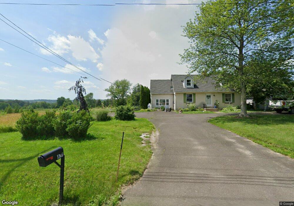
3851 Ferry Rd Doylestown, PA 18902
Plumstead NeighborhoodEstimated Value: $570,503 - $615,000
3
Beds
2
Baths
1,901
Sq Ft
$307/Sq Ft
Est. Value
About This Home
This home is located at 3851 Ferry Rd, Doylestown, PA 18902 and is currently estimated at $584,376, approximately $307 per square foot. 3851 Ferry Rd is a home located in Bucks County with nearby schools including Groveland Elementary School, Tohickon Middle School, and Central Bucks High School-West.
Ownership History
Date
Name
Owned For
Owner Type
Purchase Details
Closed on
Feb 10, 2022
Sold by
Hirst James R
Bought by
Hirst William J and Hirst Marjorie Y
Current Estimated Value
Purchase Details
Closed on
May 4, 2018
Sold by
Huirst William J and Huirst Morjorie Y
Bought by
Hirst James R and Hirst Michael S
Purchase Details
Closed on
Dec 6, 2000
Sold by
Hirst William and Hirst Marjorie
Bought by
The Hirst Family Trust
Create a Home Valuation Report for This Property
The Home Valuation Report is an in-depth analysis detailing your home's value as well as a comparison with similar homes in the area
Home Values in the Area
Average Home Value in this Area
Purchase History
| Date | Buyer | Sale Price | Title Company |
|---|---|---|---|
| Hirst William J | -- | None Listed On Document | |
| Hirst James R | -- | None Available | |
| The Hirst Family Trust | -- | -- |
Source: Public Records
Tax History
| Year | Tax Paid | Tax Assessment Tax Assessment Total Assessment is a certain percentage of the fair market value that is determined by local assessors to be the total taxable value of land and additions on the property. | Land | Improvement |
|---|---|---|---|---|
| 2025 | $5,838 | $33,600 | $13,280 | $20,320 |
| 2024 | $5,838 | $33,600 | $13,280 | $20,320 |
| 2023 | $5,653 | $33,600 | $13,280 | $20,320 |
| 2022 | $5,589 | $33,600 | $13,280 | $20,320 |
| 2021 | $5,527 | $33,600 | $13,280 | $20,320 |
| 2020 | $5,527 | $33,600 | $13,280 | $20,320 |
| 2019 | $5,493 | $33,600 | $13,280 | $20,320 |
| 2018 | $5,493 | $33,600 | $13,280 | $20,320 |
| 2017 | $5,418 | $33,600 | $13,280 | $20,320 |
| 2016 | $5,418 | $33,600 | $13,280 | $20,320 |
| 2015 | -- | $33,600 | $13,280 | $20,320 |
| 2014 | -- | $33,600 | $13,280 | $20,320 |
Source: Public Records
Map
Nearby Homes
- 3752 William Daves Rd Unit 7
- 3688 Christopher Day Rd
- 3611 Jacob Stout Rd Unit 7
- 3622 Alley E
- 4570 Louise Saint Claire Dr
- 4317 Kleinot Dr
- 4464 Kleinot Dr
- 4330 Kleinot Dr
- 4246 Kleinot Dr
- 4298 Kleinot Dr
- 4306 Kleinot Dr
- 4215 Ferguson Dr
- 30 John Dyer Way
- 4625 Old Oak Rd
- LOT 1 Curly Hill Rd
- 4745 Nottingham Way
- 7 Broadale Ct
- 4783 Landisville Rd
- 4179 Miladies Ln
- 4 Windey Way Ln
- 7453 Ferry Rd
- 0 Ferry Rd Unit 6988440
- 0 Ferry Rd Unit 6988434
- 3877 Ferry Rd
- 3883 Ferry Rd
- 4920 Gayman Rd
- 4930 Gayman Rd
- 3897 Gayman Rd
- 4936 Gayman Rd
- 3798 Ferry Rd
- 3793 Ferry Rd
- 4933 Gayman Rd
- 4905 Gayman Rd
- 4951 Gayman Rd
- 4965 Gayman Rd
- 4984 Gayman Rd
- 3951 Ferry Rd
- 5016 Gayman Rd
- 3967 Ferry Rd
- 3966 Ferry Rd
Your Personal Tour Guide
Ask me questions while you tour the home.