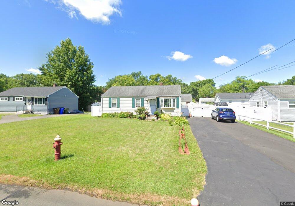
39 Brookside Cir Wethersfield, CT 06109
Estimated Value: $258,000 - $298,118
3
Beds
1
Bath
888
Sq Ft
$314/Sq Ft
Est. Value
About This Home
This home is located at 39 Brookside Cir, Wethersfield, CT 06109 and is currently estimated at $278,530, approximately $313 per square foot. 39 Brookside Cir is a home located in Hartford County with nearby schools including Emerson-Williams School, Silas Deane Middle School, and Wethersfield High School.
Ownership History
Date
Name
Owned For
Owner Type
Purchase Details
Closed on
Jan 5, 2018
Sold by
Wells Fargo Bank Na
Bought by
Nguyen Phuong H
Current Estimated Value
Home Financials for this Owner
Home Financials are based on the most recent Mortgage that was taken out on this home.
Original Mortgage
$75,000
Outstanding Balance
$63,259
Interest Rate
3.92%
Mortgage Type
New Conventional
Estimated Equity
$215,271
Purchase Details
Closed on
Nov 15, 2017
Sold by
Cong-Phan Thanh
Bought by
Nguyen Phuong H
Home Financials for this Owner
Home Financials are based on the most recent Mortgage that was taken out on this home.
Original Mortgage
$75,000
Outstanding Balance
$63,259
Interest Rate
3.92%
Mortgage Type
New Conventional
Estimated Equity
$215,271
Purchase Details
Closed on
Oct 19, 1999
Sold by
Chlodnicki Stanley and Chlodnicki Elizabeth
Bought by
Phan Thanh Cong and Nguyen Phyong H
Create a Home Valuation Report for This Property
The Home Valuation Report is an in-depth analysis detailing your home's value as well as a comparison with similar homes in the area
Home Values in the Area
Average Home Value in this Area
Purchase History
| Date | Buyer | Sale Price | Title Company |
|---|---|---|---|
| Nguyen Phuong H | -- | -- | |
| Nguyen Phuong H | -- | -- | |
| Phan Thanh Cong | $92,000 | -- |
Source: Public Records
Mortgage History
| Date | Status | Borrower | Loan Amount |
|---|---|---|---|
| Open | Phan Thanh Cong | $75,000 | |
| Previous Owner | Phan Thanh Cong | $20,000 | |
| Previous Owner | Phan Thanh Cong | $100,000 |
Source: Public Records
Tax History
| Year | Tax Paid | Tax Assessment Tax Assessment Total Assessment is a certain percentage of the fair market value that is determined by local assessors to be the total taxable value of land and additions on the property. | Land | Improvement |
|---|---|---|---|---|
| 2025 | $6,351 | $154,070 | $63,170 | $90,900 |
| 2024 | $4,728 | $109,390 | $57,520 | $51,870 |
| 2023 | $4,570 | $109,390 | $57,520 | $51,870 |
| 2022 | $4,494 | $109,390 | $57,520 | $51,870 |
| 2021 | $4,449 | $109,390 | $57,520 | $51,870 |
| 2020 | $4,451 | $109,390 | $57,520 | $51,870 |
| 2019 | $4,457 | $109,390 | $57,520 | $51,870 |
| 2018 | $4,257 | $104,400 | $54,200 | $50,200 |
| 2017 | $4,152 | $104,400 | $54,200 | $50,200 |
| 2016 | $4,024 | $104,400 | $54,200 | $50,200 |
| 2015 | $3,987 | $104,400 | $54,200 | $50,200 |
| 2014 | $3,836 | $104,400 | $54,200 | $50,200 |
Source: Public Records
Map
Nearby Homes
- 1 Brussels Ave
- 19 Albert Ave
- 1 Bristol St
- 219-221 Jordan Ln
- 192 Wolcott Hill Rd
- 55 Rutledge Rd
- 295 Ridge Rd Unit 8
- 64 Cromwell St
- 144 Brown St
- 107 Harmund Place
- 23 Hillcrest Ave
- 28 Bolton St
- 166 George St
- 18 Avalon Place
- 51 Hanmer St
- 317-319 Garden St
- 1 Fernwood St
- 208 Mountain St
- 2020 Broad St Unit 6
- 63 Wells Farm Dr
- 33 Brookside Cir
- 43 Brookside Cir
- 122 Brookside Cir
- 128 Brookside Cir
- 116 Brookside Cir
- 27 Brookside Cir
- 49 Brookside Cir
- 40 Brookside Cir
- 34 Brookside Cir
- 132 Brookside Cir
- 44 Brookside Cir
- 112 Brookside Cir
- 21 Brookside Cir
- 50 Brookside Cir
- 55 Brookside Cir
- 142 Brookside Cir
- 106 Brookside Cir
- 121 Brookside Cir
- 127 Brookside Cir
- 115 Brookside Cir
Your Personal Tour Guide
Ask me questions while you tour the home.