Estimated Value: $627,599 - $806,000
3
Beds
3
Baths
1,407
Sq Ft
$517/Sq Ft
Est. Value
About This Home
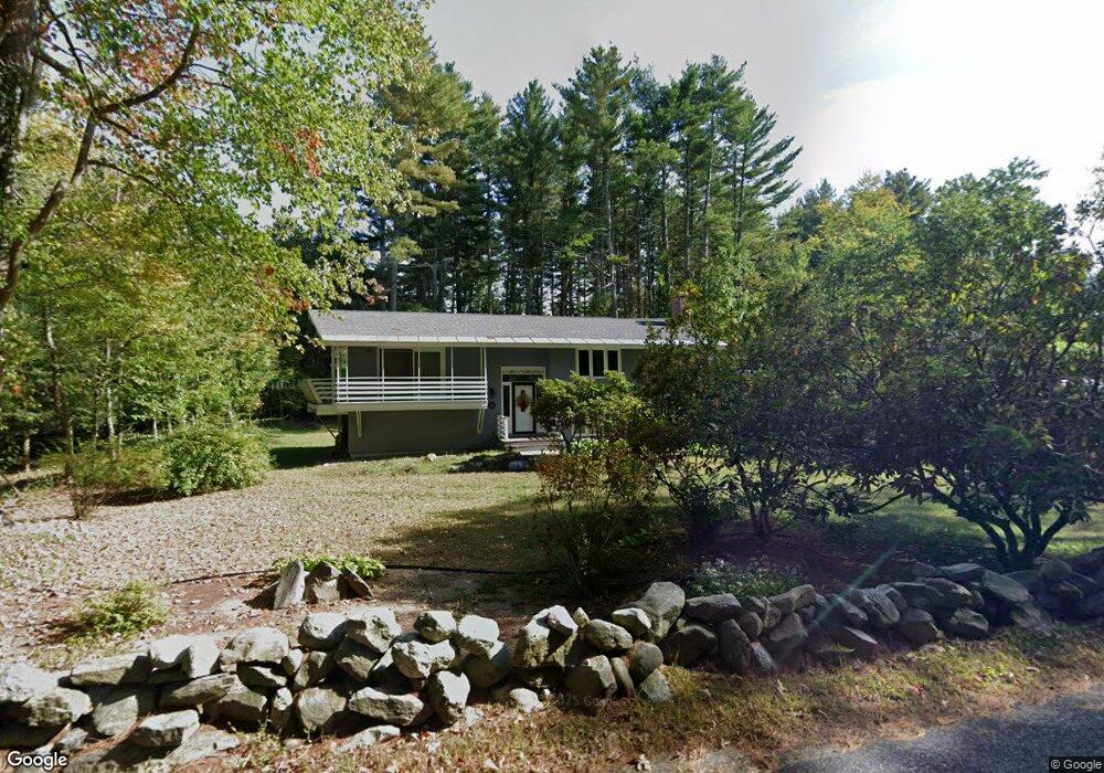
This home is located at 39 Garner Rd, Stow, MA 01775 and is currently estimated at $727,900, approximately $517 per square foot. 39 Garner Rd is a home located in Middlesex County with nearby schools including Center School, Hale Middle School, and Nashoba Regional High School.
Ownership History
Date
Name
Owned For
Owner Type
Purchase Details
Closed on
Jul 29, 2014
Sold by
Cusick Jeanne F
Bought by
Jeanne Cusick Ret and Cusick Jeanne T
Current Estimated Value
Purchase Details
Closed on
Jun 24, 1988
Sold by
Zurawski John
Bought by
Cuscik Jeanne F
Create a Home Valuation Report for This Property
The Home Valuation Report is an in-depth analysis detailing your home's value as well as a comparison with similar homes in the area
Home Values in the Area
Average Home Value in this Area
Purchase History
| Date | Buyer | Sale Price | Title Company |
|---|---|---|---|
| Jeanne Cusick Ret | -- | -- | |
| Cuscik Jeanne F | $232,000 | -- |
Source: Public Records
Mortgage History
| Date | Status | Borrower | Loan Amount |
|---|---|---|---|
| Previous Owner | Cuscik Jeanne F | $100,000 | |
| Previous Owner | Cuscik Jeanne F | $115,000 | |
| Previous Owner | Cuscik Jeanne F | $40,500 |
Source: Public Records
Tax History
| Year | Tax Paid | Tax Assessment Tax Assessment Total Assessment is a certain percentage of the fair market value that is determined by local assessors to be the total taxable value of land and additions on the property. | Land | Improvement |
|---|---|---|---|---|
| 2025 | $10,543 | $605,200 | $354,700 | $250,500 |
| 2024 | $11,585 | $682,700 | $390,000 | $292,700 |
| 2023 | $11,369 | $627,100 | $348,600 | $278,500 |
| 2022 | $10,989 | $561,800 | $268,600 | $293,200 |
| 2021 | $10,539 | $527,500 | $268,600 | $258,900 |
| 2020 | $8,829 | $428,400 | $247,800 | $180,600 |
| 2019 | $8,791 | $436,700 | $247,800 | $188,900 |
| 2018 | $8,761 | $417,600 | $247,800 | $169,800 |
| 2017 | $8,386 | $407,300 | $220,800 | $186,500 |
| 2016 | $8,312 | $416,000 | $220,800 | $195,200 |
| 2015 | $7,718 | $386,300 | $200,700 | $185,600 |
Source: Public Records
Map
Nearby Homes
- 352 Taylor Rd
- 555 Old Harvard Rd
- 500 Old Harvard Rd
- 53 Sylvan Dr
- 308 Harvard Rd
- 21 Sylvan Dr
- 212 Taylor Rd
- 3 Pine Hill Way
- 14 Pine Hill Way
- 16 A Pine Hill Way Unit 16AA
- 18 B Pine Hill Way Unit BB
- 39 Ridgewood Dr Unit 39
- 40 Ridgewood Dr Unit 40
- 45 Hiley Brook Rd
- 17 W View Ln Unit 17
- 40 Fifers Ln
- 310 Codman Hill Rd Unit 35D
- 276 Codman Hill Rd Unit 36A
- 79 Taylor Rd
- 20 Lyons Ln Unit 20
- 1 No Name Rd
- 35 Garner Rd
- LOT 1 Bradley Ln
- LOT 6 Kettell Plain Rd
- Lot 44 Whispering Way
- LOT B Maple St
- LOT 2 Kettell Plain Rd
- LOT 3 Fox Ct
- LOT 1 Robinwood Ln
- Lot 45 Whispering Way
- LOT 6 Brandymeade Cir
- LOT 2 Brandymeade Cir
- LOT7 Brandymeade Cir
- LOT 1 Packard Rd
- LOT 1 Wheeler Rd
- LT 4 Wheeler Rd
- LT 3 Wheeler Rd
- LOT 31 Whispering Way
- LOT 1 Edson Rd
- LOT 13 Kettell Plain Rd
Your Personal Tour Guide
Ask me questions while you tour the home.