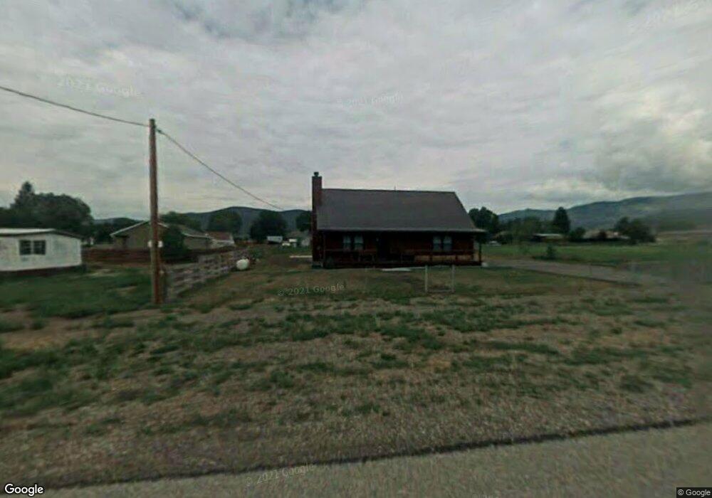
39 N 200 St E Koosharem, UT 84744
Estimated Value: $338,302 - $491,000
3
Beds
2
Baths
1,600
Sq Ft
$259/Sq Ft
Est. Value
About This Home
This home is located at 39 N 200 St E, Koosharem, UT 84744 and is currently estimated at $413,826, approximately $258 per square foot. 39 N 200 St E is a home located in Sevier County with nearby schools including Koosharem Elementary School, South Sevier Middle School, and South Sevier High School.
Ownership History
Date
Name
Owned For
Owner Type
Purchase Details
Closed on
Apr 25, 2025
Sold by
Rojas Robert and Rojas Nicholas
Bought by
Robert Rojas Family Trust and Rojas
Current Estimated Value
Purchase Details
Closed on
Sep 6, 2006
Sold by
Rojas Robert
Bought by
Rojas Robert and Rojas Nicholas
Purchase Details
Closed on
Aug 21, 2006
Sold by
Simonson Gary W and Simonson Allene
Bought by
Rojas Robert
Purchase Details
Closed on
Aug 1, 2005
Sold by
Torgerson Jason Farrell and Torgerson Jayleen
Bought by
Simonson Gary and Simonson Allene
Create a Home Valuation Report for This Property
The Home Valuation Report is an in-depth analysis detailing your home's value as well as a comparison with similar homes in the area
Purchase History
| Date | Buyer | Sale Price | Title Company |
|---|---|---|---|
| Robert Rojas Family Trust | -- | None Listed On Document | |
| Rojas Robert | -- | D Land Title | |
| Rojas Robert | -- | D Land Title | |
| Simonson Gary | -- | D Land Title |
Source: Public Records
Tax History
| Year | Tax Paid | Tax Assessment Tax Assessment Total Assessment is a certain percentage of the fair market value that is determined by local assessors to be the total taxable value of land and additions on the property. | Land | Improvement |
|---|---|---|---|---|
| 2025 | $1,711 | $211,186 | $29,480 | $181,706 |
| 2024 | $1,762 | $213,187 | $26,800 | $186,387 |
| 2023 | $1,475 | $174,047 | $22,276 | $151,771 |
| 2022 | $1,411 | $147,763 | $21,287 | $126,476 |
| 2021 | $1,646 | $143,635 | $11,009 | $132,626 |
| 2020 | $1,418 | $116,612 | $9,174 | $107,438 |
| 2019 | $977 | $85,820 | $9,170 | $76,650 |
| 2018 | $1,095 | $85,820 | $9,170 | $76,650 |
| 2017 | $1,738 | $130,300 | $15,290 | $115,010 |
| 2016 | $601 | $130,300 | $0 | $0 |
| 2015 | $601 | $130,300 | $0 | $0 |
| 2014 | $601 | $112,040 | $0 | $0 |
Source: Public Records
Map
Nearby Homes
- 10 S 200 W
- 290 N 300 W
- 160 W 600 N
- 3810 N Burrville Rd
- 3810 N Burrville Rd
- 2033 S Sleepy Sage Ln
- 45 W Twin Creeks Rd
- Tbd 123 Monroe Canyon Rd
- 0 Monroe Mountain Rd
- 351 W Skyline Dr
- 2 N Landslide Rd E
- 123 Tbd Monroe Canyon Rd
- 7 W 725 N Unit 7
- 3 N Landslide Rd E Unit 3
- 123 Tbd West Cuonty Rd 1875
- 3 W 725 N Unit 3
- 4 W 725 N Unit 4
- 8 W 725 N Unit 8
- 1 N Landslide Rd E
- 479 S 500 St W
Your Personal Tour Guide
Ask me questions while you tour the home.