Estimated Value: $357,235 - $399,000
3
Beds
2
Baths
1,490
Sq Ft
$258/Sq Ft
Est. Value
About This Home
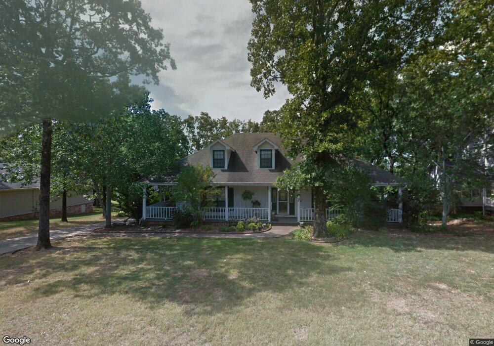
This home is located at 39 Ridge Rd, Cabot, AR 72023 and is currently estimated at $383,745, approximately $257 per square foot. 39 Ridge Rd is a home located in Lonoke County with nearby schools including Northside Elementary School, Cabot Junior High North, and Cabot Middle School North.
Ownership History
Date
Name
Owned For
Owner Type
Purchase Details
Closed on
Sep 10, 2020
Sold by
Carter Dale and Carter Susan D
Bought by
Sharp Heidi Jo and Sharp Dustin Lynn
Current Estimated Value
Home Financials for this Owner
Home Financials are based on the most recent Mortgage that was taken out on this home.
Original Mortgage
$244,000
Outstanding Balance
$215,634
Interest Rate
2.8%
Mortgage Type
New Conventional
Estimated Equity
$168,111
Purchase Details
Closed on
Oct 22, 2004
Bought by
Carter and Carter Wf
Purchase Details
Closed on
Oct 15, 2004
Bought by
Carter and Carter Wf
Purchase Details
Closed on
Sep 5, 2002
Bought by
Jr Rogers and Jr Wf
Purchase Details
Closed on
Jun 5, 1991
Bought by
Brannan and Wife Wanda
Purchase Details
Closed on
May 28, 1991
Bought by
Sunland
Create a Home Valuation Report for This Property
The Home Valuation Report is an in-depth analysis detailing your home's value as well as a comparison with similar homes in the area
Purchase History
| Date | Buyer | Sale Price | Title Company |
|---|---|---|---|
| Sharp Heidi Jo | $260,000 | Realty T&E Svcs Inc | |
| Sharp Heidi Jo | $260,000 | None Listed On Document | |
| Carter | $199,000 | -- | |
| Carter | $199,000 | -- | |
| Jr Rogers | $164,000 | -- | |
| Brannan | $14,000 | -- | |
| Sunland | -- | -- |
Source: Public Records
Mortgage History
| Date | Status | Borrower | Loan Amount |
|---|---|---|---|
| Open | Sharp Heidi Jo | $244,000 | |
| Closed | Sharp Heidi Jo | $244,000 |
Source: Public Records
Tax History
| Year | Tax Paid | Tax Assessment Tax Assessment Total Assessment is a certain percentage of the fair market value that is determined by local assessors to be the total taxable value of land and additions on the property. | Land | Improvement |
|---|---|---|---|---|
| 2025 | $2,035 | $39,990 | $3,800 | $36,190 |
| 2024 | $2,035 | $39,990 | $3,800 | $36,190 |
| 2023 | $2,035 | $39,990 | $3,800 | $36,190 |
| 2022 | $2,035 | $39,990 | $3,800 | $36,190 |
| 2021 | $2,035 | $39,990 | $3,800 | $36,190 |
| 2020 | $1,648 | $39,740 | $3,800 | $35,940 |
| 2019 | $1,648 | $39,740 | $3,800 | $35,940 |
| 2018 | $1,613 | $39,740 | $3,800 | $35,940 |
| 2017 | $1,819 | $39,740 | $3,800 | $35,940 |
| 2016 | $1,607 | $39,740 | $3,800 | $35,940 |
| 2015 | $1,514 | $37,730 | $3,800 | $33,930 |
| 2014 | $1,514 | $37,730 | $3,800 | $33,930 |
Source: Public Records
Map
Nearby Homes
- 41 Sunset Ln
- 24 Sunset Ln
- 3A W Main St
- 0 Tract F Hwy 89
- 0 Tract G Hwy 89
- 0 Tract E Hwy 89
- 0 Tract C Hwy 89
- 18 Suncrest Dr
- 0 N Rockwood Rd Unit W. Main Street
- 55 Mount Tabor W
- 505 Sweet Gum Ct
- 35 N Sunland Dr
- 222 N Summit Dr
- 504 Sweet Gum Ct
- 519 Crepe Myrtle Loop
- 218 N Summit Dr
- 509 Crepe Myrtle Loop
- 21 Blanchard Dr
- 15 Blanchard Dr
- 723 Mountain Springs Rd
Your Personal Tour Guide
Ask me questions while you tour the home.