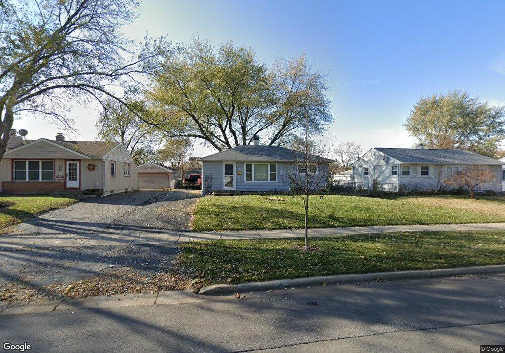
3905 Jay Ln Rolling Meadows, IL 60008
Estimated Value: $309,943 - $336,000
2
Beds
1
Bath
997
Sq Ft
$327/Sq Ft
Est. Value
About This Home
This home is located at 3905 Jay Ln, Rolling Meadows, IL 60008 and is currently estimated at $326,236, approximately $327 per square foot. 3905 Jay Ln is a home located in Cook County with nearby schools including Kimball Hill Elementary School, Carl Sandburg Junior High School, and Rolling Meadows High School.
Ownership History
Date
Name
Owned For
Owner Type
Purchase Details
Closed on
Jun 20, 2024
Sold by
Anderson Richard Don and Richard And Gail Anderson Declaration Of
Bought by
Richard Don Anderson Revocable Trust and Gail Leann Anderson Revocable Trust
Current Estimated Value
Purchase Details
Closed on
Mar 14, 2016
Sold by
Anderson Richard Don and Anderson Gail Leann
Bought by
The Richard And Gail Anderson Declaratio
Create a Home Valuation Report for This Property
The Home Valuation Report is an in-depth analysis detailing your home's value as well as a comparison with similar homes in the area
Home Values in the Area
Average Home Value in this Area
Purchase History
| Date | Buyer | Sale Price | Title Company |
|---|---|---|---|
| Richard Don Anderson Revocable Trust | -- | None Listed On Document | |
| The Richard And Gail Anderson Declaratio | -- | None Available |
Source: Public Records
Tax History
| Year | Tax Paid | Tax Assessment Tax Assessment Total Assessment is a certain percentage of the fair market value that is determined by local assessors to be the total taxable value of land and additions on the property. | Land | Improvement |
|---|---|---|---|---|
| 2025 | $5,220 | $26,000 | $5,265 | $20,735 |
| 2024 | $5,220 | $23,000 | $4,455 | $18,545 |
| 2023 | $4,944 | $23,000 | $4,455 | $18,545 |
| 2022 | $4,944 | $23,000 | $4,455 | $18,545 |
| 2021 | $3,730 | $17,258 | $2,632 | $14,626 |
| 2020 | $3,919 | $17,704 | $2,632 | $15,072 |
| 2019 | $3,959 | $19,782 | $2,632 | $17,150 |
| 2018 | $3,402 | $16,687 | $2,430 | $14,257 |
| 2017 | $3,813 | $18,093 | $2,430 | $15,663 |
| 2016 | $5,348 | $18,093 | $2,430 | $15,663 |
| 2015 | $4,189 | $17,800 | $2,227 | $15,573 |
| 2014 | $4,352 | $18,563 | $2,227 | $16,336 |
| 2013 | $5,568 | $18,563 | $2,227 | $16,336 |
Source: Public Records
Map
Nearby Homes
- 3717 Oriole Ln
- 2404 Hawk Ln
- 2830 Northampton Dr Unit A1
- 2950 Northampton Dr Unit B2
- 3101 Thrush Ln
- 3610 Pheasant Dr
- 1107 S Old Wilke Rd Unit 103
- 1107 S Old Wilke Rd Unit 208
- 1117 S Old Wilke Rd Unit 206
- 3200 Thrush Ln
- 2201 Kingfisher Ln
- 2508 Algonquin Rd Unit 16
- 2707 Lily Ln
- 2720 Lily Ln
- 3306 Trillium Cir Unit 3001
- 2504 Algonquin Rd Unit 14
- 5000 Carriageway Dr Unit 211
- 5001 Carriage Way Dr Unit 116
- 2109 Park St
- 1227 S Old Wilke Rd Unit 306
Your Personal Tour Guide
Ask me questions while you tour the home.