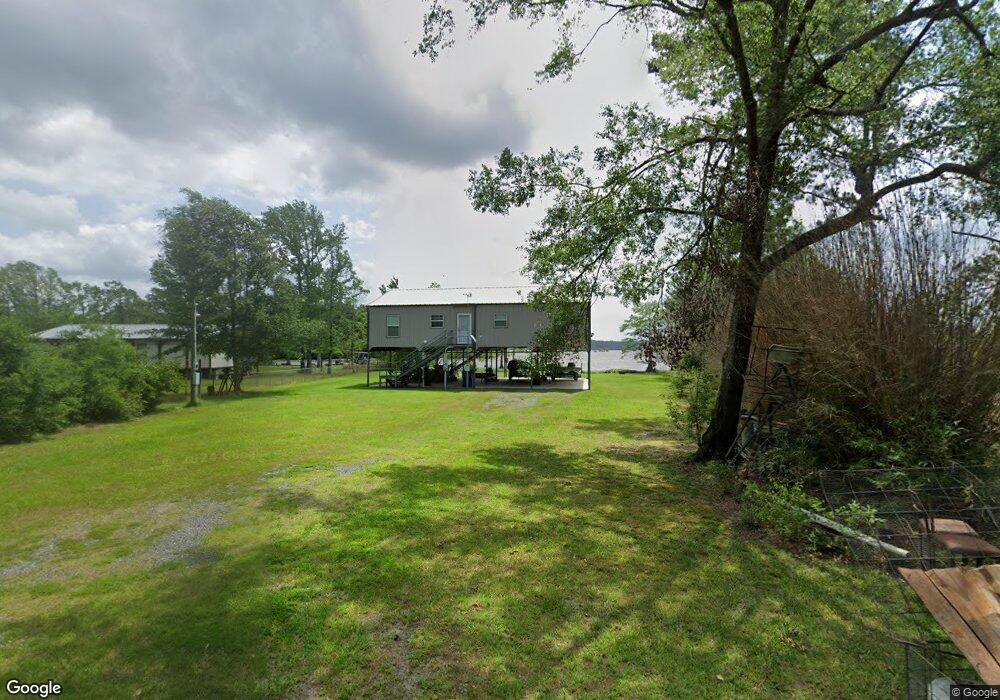
391 Peavy Rd Leesville, LA 71446
Estimated Value: $104,923 - $330,000
Studio
--
Bath
--
Sq Ft
43,560
Sq Ft Lot
About This Home
This home is located at 391 Peavy Rd, Leesville, LA 71446 and is currently estimated at $196,481. 391 Peavy Rd is a home located in Vernon Parish.
Ownership History
Date
Name
Owned For
Owner Type
Purchase Details
Closed on
Jan 28, 2025
Sold by
Fontenot Kendal Wayne and Fontenot Krista Nicole
Bought by
Fontenot Robert John and Fontenot Jeanne P
Current Estimated Value
Purchase Details
Closed on
Aug 22, 2014
Sold by
Carlock Jamie Adam
Bought by
Fontenot Kendal Wayne and Fontenot Krista Ryder
Home Financials for this Owner
Home Financials are based on the most recent Mortgage that was taken out on this home.
Original Mortgage
$58,500
Interest Rate
4.15%
Mortgage Type
New Conventional
Purchase Details
Closed on
Nov 30, 2007
Sold by
Conn Linda Lawrence
Bought by
Holt Marcus A and Holt Amber R O'Banion
Home Financials for this Owner
Home Financials are based on the most recent Mortgage that was taken out on this home.
Original Mortgage
$65,000
Interest Rate
6.27%
Mortgage Type
Unknown
Create a Home Valuation Report for This Property
The Home Valuation Report is an in-depth analysis detailing your home's value as well as a comparison with similar homes in the area
Purchase History
| Date | Buyer | Sale Price | Title Company |
|---|---|---|---|
| Fontenot Robert John | -- | None Listed On Document | |
| Fontenot Kendal Wayne | $65,000 | -- | |
| Holt Marcus A | $65,000 | -- |
Source: Public Records
Mortgage History
| Date | Status | Borrower | Loan Amount |
|---|---|---|---|
| Previous Owner | Fontenot Kendal Wayne | $58,500 | |
| Previous Owner | Holt Marcus A | $65,000 | |
| Previous Owner | Holt Marcus A | $65,000 |
Source: Public Records
Tax History
| Year | Tax Paid | Tax Assessment Tax Assessment Total Assessment is a certain percentage of the fair market value that is determined by local assessors to be the total taxable value of land and additions on the property. | Land | Improvement |
|---|---|---|---|---|
| 2025 | $1,087 | $9,100 | $320 | $8,780 |
| 2024 | $1,098 | $9,100 | $320 | $8,780 |
| 2023 | $1,125 | $9,090 | $290 | $8,800 |
| 2022 | $1,000 | $9,090 | $290 | $8,800 |
| 2021 | $1,150 | $8,290 | $290 | $8,000 |
| 2020 | $1,271 | $8,290 | $290 | $8,000 |
| 2019 | $1,120 | $8,290 | $290 | $8,000 |
| 2018 | $1,199 | $8,290 | $290 | $8,000 |
| 2017 | $39 | $290 | $290 | $0 |
| 2015 | $771 | $5,570 | $70 | $5,500 |
| 2014 | $717 | $5,570 | $70 | $5,500 |
| 2013 | $838 | $5,570 | $70 | $5,500 |
Source: Public Records
Map
Nearby Homes
- 0 Tbd Hwy 8 & 464 Unit 29-1650
- 0 Hwy 8 & 464 Hwy Unit SWL22004749
- 0 Lot 7 Woodland Park Phase III Unit 29-1652
- 149 Methodist Landing Rd
- 0 Archie Wilbert Rd
- 601 Vinson Rd
- 0 Woods Rd Unit RD
- 588 Hickory Ridge Rd
- 0 Empire Point Rd
- 0 Nichols Rd
- 115 Deerhunter Ln
- 1976 Savage Forks Rd
- 128 Kelley St
- 728 Section Line Rd
- 147 Blackmon Rd
- 579 Lake Vernon Rd
- 708 Woodland Dr
- 1109 Nicholas Dr
- 0 Mt Pleasant Cemetery Rd
- TBD Driftwood Dr
- 366 Peavy Rd
- 398 Peavy Rd
- 348 Peavy Rd
- 314 Peavy Rd
- 267 Rabbit Island Ln
- 254 Rabbit Island Ln
- 163 Fords Landing Rd
- 176 Rabbit Island Ln
- 117 Rabbit Island Ln
- 151 White Rd
- 151 White Rd Unit Road
- 137 White Rd
- 148 Highway 464
- 161 Cole Rd
- 368 Peavy Rd
- 906 Louisiana 464
- 906 Louisiana 464
- 128 Schwartz Rd
- 160 Cole Rd
- 289 Louisiana 464
Your Personal Tour Guide
Ask me questions while you tour the home.