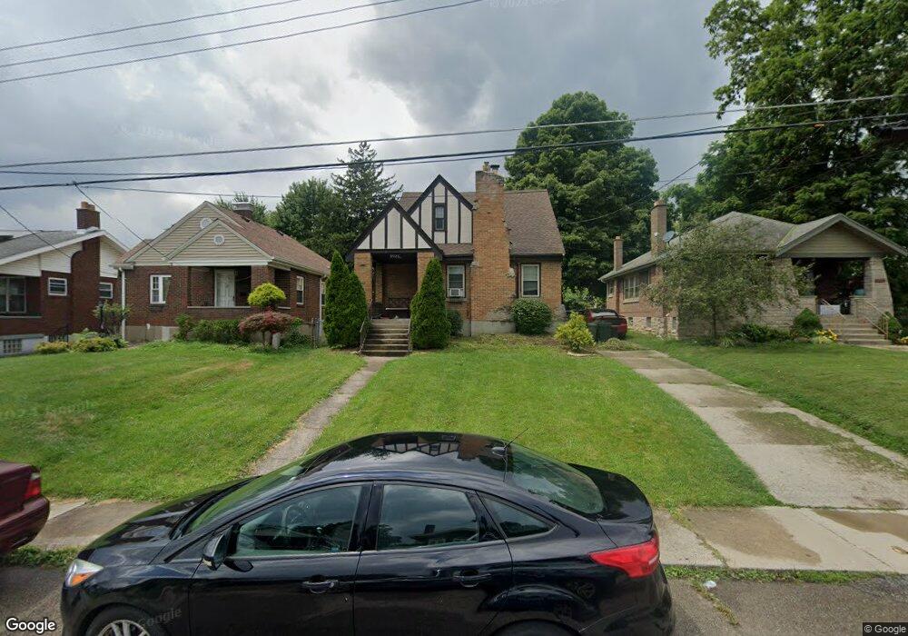
3923 Taft Ave Cincinnati, OH 45211
Estimated Value: $212,000 - $273,000
About This Home
This home is located at 3923 Taft Ave, Cincinnati, OH 45211 and is currently estimated at $231,595, approximately $145 per square foot. 3923 Taft Ave is a home located in Hamilton County with nearby schools including Cheviot Elementary School, Western Hills High School, and Gilbert A. Dater High School.
Ownership History
We collect this data history from publicly available records. To have your information removed, we recommend requesting removal directly through your county’s website.
Purchase Details
Home Financials for this Owner
Home Financials are based on the most recent Mortgage that was taken out on this home.Purchase Details
Home Values in the Area
Average Home Value in this Area
Purchase History
We collect this data history from publicly available records. To have your information removed, we recommend requesting removal directly through your county’s website.
| Date | Buyer | Sale Price | Title Company |
|---|---|---|---|
| $128,000 | None Available | ||
| $69,700 | -- |
Mortgage History
We collect this data history from publicly available records. To have your information removed, we recommend requesting removal directly through your county’s website.
| Date | Status | Borrower | Loan Amount |
|---|---|---|---|
| Open | $125,681 |
Tax History
We collect this data history from publicly available records. To have your information removed, we recommend requesting removal directly through your county’s website.
| Year | Tax Paid | Tax Assessment Tax Assessment Total Assessment is a certain percentage of the fair market value that is determined by local assessors to be the total taxable value of land and additions on the property. | Land | Improvement |
|---|---|---|---|---|
| 2025 | $3,072 | $49,239 | $6,878 | $42,361 |
| 2023 | $3,048 | $49,239 | $6,878 | $42,361 |
| 2022 | $3,202 | $44,801 | $5,954 | $38,847 |
| 2021 | $3,123 | $44,801 | $5,954 | $38,847 |
| 2020 | $3,168 | $44,801 | $5,954 | $38,847 |
| 2019 | $2,463 | $31,294 | $5,268 | $26,026 |
| 2018 | $2,836 | $31,294 | $5,268 | $26,026 |
| 2017 | $2,728 | $31,294 | $5,268 | $26,026 |
| 2016 | $2,580 | $33,579 | $5,425 | $28,154 |
| 2015 | $2,343 | $33,579 | $5,425 | $28,154 |
| 2014 | $2,289 | $33,579 | $5,425 | $28,154 |
| 2013 | $2,255 | $32,603 | $5,268 | $27,335 |
Map
- 3914 Meyerfeld Ave
- 3873 Meyerfeld Ave
- 3869 Meyerfeld Ave
- 3311 Augusta Ave
- 3665 Boudinot Ave
- 3845 Olivette Ave
- 3301 Camvic Terrace
- 3097 Westwood Northern Blvd
- 3122 Westwood Northern Blvd
- 3118 Westwood Northern Blvd
- 3940 Delmar Ave
- 3820 Delmar Ave
- 3047 Feltz Ave
- 3601 Puhlman Ave
- 3606 Gamble Ave
- 3608 Gamble Ave
- 3977 Delmar Ave
- 3718 Forest Ct
- 3719 Forest Ct
- 4117 N Bend Rd
- 3908 Meyerfeld Ave
- 3906 Meyerfeld Ave
- 3904 Meyerfeld Ave
- 3918 Meyerfeld Ave
- 3902 Meyerfeld Ave
- 3922 Meyerfeld Ave
- 3915 Taft Ave
- 3911 Taft Ave
- 3919 Taft Ave
- 3907 Taft Ave
- 3900 Meyerfeld Ave
- 3909 Meyerfeld Ave
- 3907 Meyerfeld Ave
- 3911 Meyerfeld Ave
- 3903 Taft Ave
- 3927 Taft Ave
- 3915 Meyerfeld Ave
- 3905 Meyerfeld Ave
- 3919 Meyerfeld Ave
- 3903 Meyerfeld Ave
Ask me questions while you tour the home.