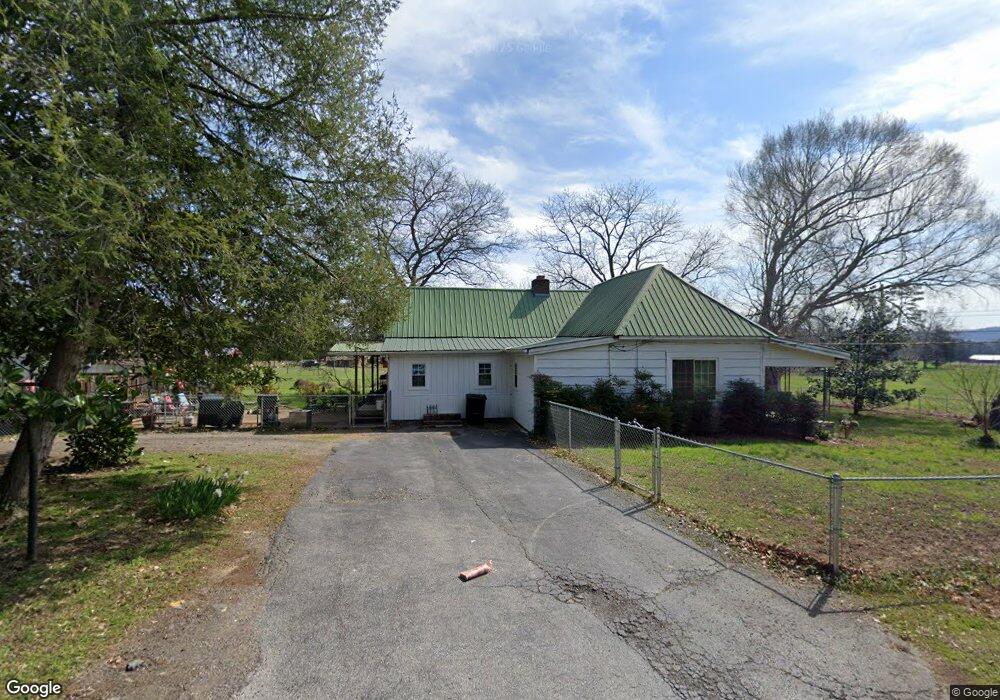
393 Cooper Rd Rock Spring, GA 30739
Rock Spring NeighborhoodEstimated Value: $304,000 - $442,000
Studio
1
Bath
2,738
Sq Ft
$131/Sq Ft
Est. Value
About This Home
This home is located at 393 Cooper Rd, Rock Spring, GA 30739 and is currently estimated at $358,022, approximately $130 per square foot. 393 Cooper Rd is a home located in Walker County with nearby schools including Rock Spring Elementary School and Lafayette High School.
Ownership History
Date
Name
Owned For
Owner Type
Purchase Details
Closed on
Aug 5, 1994
Sold by
Brown James A and Virgie Lee
Bought by
Shields Mark R
Current Estimated Value
Purchase Details
Closed on
Apr 12, 1994
Sold by
Allmon James M and Allmon Nelva L
Bought by
Brown James A and Virgie Lee
Purchase Details
Closed on
Aug 6, 1987
Sold by
James Brown
Bought by
Allmon James M and Allmon Nelva L
Purchase Details
Closed on
Jan 1, 1965
Bought by
James Brown
Create a Home Valuation Report for This Property
The Home Valuation Report is an in-depth analysis detailing your home's value as well as a comparison with similar homes in the area
Home Values in the Area
Average Home Value in this Area
Purchase History
We collect this data history from publicly available records. To have your information removed, we recommend requesting removal directly through your county’s website.
| Date | Buyer | Sale Price | Title Company |
|---|---|---|---|
| Shields Mark R | $40,000 | -- | |
| Brown James A | $40,000 | -- | |
| Allmon James M | $48,000 | -- | |
| James Brown | -- | -- |
Source: Public Records
Tax History
| Year | Tax Paid | Tax Assessment Tax Assessment Total Assessment is a certain percentage of the fair market value that is determined by local assessors to be the total taxable value of land and additions on the property. | Land | Improvement |
|---|---|---|---|---|
| 2025 | $2,462 | $105,173 | $8,120 | $97,053 |
| 2024 | $2,519 | $101,001 | $7,733 | $93,268 |
| 2023 | $2,426 | $94,569 | $6,137 | $88,432 |
| 2022 | $2,205 | $81,251 | $4,996 | $76,255 |
| 2021 | $2,103 | $69,631 | $4,996 | $64,635 |
| 2020 | $1,861 | $58,078 | $4,996 | $53,082 |
| 2019 | $1,891 | $58,078 | $4,996 | $53,082 |
| 2018 | $1,537 | $58,078 | $4,996 | $53,082 |
| 2017 | $2,051 | $58,078 | $4,996 | $53,082 |
| 2016 | $1,272 | $48,665 | $4,996 | $43,669 |
| 2015 | $870 | $30,394 | $9,296 | $21,098 |
| 2014 | $716 | $30,394 | $9,296 | $21,098 |
| 2013 | -- | $30,394 | $9,296 | $21,098 |
Source: Public Records
Map
Nearby Homes
- 1985 Peavine Rd
- 788 Long Hollow Rd
- 420 Long Hollow Rd
- 56 Saddle Brooke Ln
- 229 E Turnipseed Rd
- 1909 Old Lafayette Rd
- 3774 Mount Pisgah Rd
- 00 Georgia 95
- 449 W Watts Rd
- 1003 Highway N Old 27
- 185 Hunting Ridge Cir
- 74 Hanshaw Dr
- 0 Bicentennial Trail Unit 10742583
- 0 Bicentennial Trail Unit 7760659
- 0 Bicentennial Trail Unit 10742613
- 0 Bicentennial Trail Unit 10742617
- 0 Bicentennial Trail Unit 7760678
- 0 Bicentennial Trail Unit 7760669
- 0 Bicentennial Trail Unit 10742604
- 0 Bicentennial Trail Unit 7760681
- 50 E Acorn Dr
- 51 E Acorn Dr
- 357 Cooper Rd
- 35 E Acorn Dr
- 0 Pierce Rd Unit 1148395
- 333 Cooper Rd
- 133 Pierce Rd
- 366 Twelve Oaks Dr
- 414 Twelve Oaks Dr
- 524 Cooper Rd
- 322 Twelve Oaks Dr
- 162 Pierce Rd
- 367 Cooper Rd
- 401 Twelve Oaks Dr
- 383 Twelve Oaks Dr
- 423 Twelve Oaks Dr
- 423 Twelve Oaks Dr Unit 31
- 12 Oak Run Unit 1133423
- 12 Oak Run Unit 1133422
- 12 Oak Run Unit 1133424
Your Personal Tour Guide
Ask me questions while you tour the home.