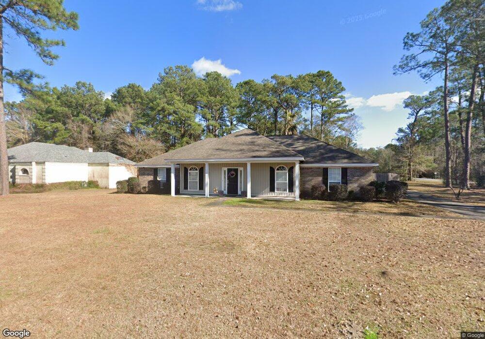
3933 St Andrews Loop E Mobile, AL 36693
Riviere Du Chien NeighborhoodEstimated Value: $349,000 - $375,000
About This Home
This home is located at 3933 St Andrews Loop E, Mobile, AL 36693 and is currently estimated at $356,064, approximately $151 per square foot. 3933 St Andrews Loop E is a home located in Mobile County with nearby schools including Kate Shepard Elementary School, Burns Middle School, and Ben C Rain High School.
Ownership History
We collect this data history from publicly available records. To have your information removed, we recommend requesting removal directly through your county’s website.
Purchase Details
Home Financials for this Owner
Home Financials are based on the most recent Mortgage that was taken out on this home.Purchase Details
Home Values in the Area
Average Home Value in this Area
Purchase History
We collect this data history from publicly available records. To have your information removed, we recommend requesting removal directly through your county’s website.
| Date | Buyer | Sale Price | Title Company |
|---|---|---|---|
| $197,000 | Dst | ||
| -- | -- |
Mortgage History
We collect this data history from publicly available records. To have your information removed, we recommend requesting removal directly through your county’s website.
| Date | Status | Borrower | Loan Amount |
|---|---|---|---|
| Open | $192,006 |
Tax History
We collect this data history from publicly available records. To have your information removed, we recommend requesting removal directly through your county’s website.
| Year | Tax Paid | Tax Assessment Tax Assessment Total Assessment is a certain percentage of the fair market value that is determined by local assessors to be the total taxable value of land and additions on the property. | Land | Improvement |
|---|---|---|---|---|
| 2025 | $1,724 | $28,020 | $4,000 | $24,020 |
| 2024 | $1,724 | $26,320 | $4,000 | $22,320 |
| 2023 | $1,616 | $23,610 | $3,990 | $19,620 |
| 2022 | $1,311 | $21,690 | $3,990 | $17,700 |
| 2021 | $1,184 | $19,670 | $3,690 | $15,980 |
| 2020 | $1,223 | $20,300 | $3,690 | $16,610 |
| 2019 | $1,150 | $19,160 | $0 | $0 |
| 2018 | $1,160 | $19,320 | $0 | $0 |
| 2017 | $1,052 | $17,620 | $0 | $0 |
| 2016 | $1,184 | $19,700 | $0 | $0 |
| 2013 | $1,262 | $19,720 | $0 | $0 |
Map
- 0 St Andrews Dr E Unit 7510683
- 3921 St Andrews Dr E
- 3820 St Andrews Loop W
- 3847 Riviere Du Chien Rd
- 3788 Cypress Shores Dr N
- 0 Riviere Du Chien Unit 7789301
- 0 Riviere Du Chien Unit 27303453
- 4031 Leighton Place Dr
- 4039 Leighton Place Dr
- 4043 Leighton Place Dr
- 3505 Shadowwood Ct
- 4046 Leighton Place Dr
- 0 Patricia Dr Unit 7279576
- 3801 Point Rd
- 4441 Nicholl Dr
- 0 Rosie Rd Unit 7487049
- 0 Rosie Rd Unit 7522718
- 3553 Wooley Rd
- 0 Rosie's Rd Unit 5 373971
- 0 Rosie's Rd Unit 2
- 3932 Saint Andrews Loop E
- 3928 Saint Andrews Loop E
- 3933 Saint Andrews Loop E
- 3801 Saint Andrews Dr
- 3805 Saint Andrews Dr
- 3925 Saint Andrews Loop E
- 3809 Saint Andrews Dr
- 3921 Saint Andrews Loop E
- 3800 St Andrews Dr
- 3800 Saint Andrews Dr
- 3804 Saint Andrews Dr
- 3813 Saint Andrews Dr
- 3808 Saint Andrews Dr
- 3917 Saint Andrews Loop E
- 3917 St Andrews Loop E
- 3817 St Andrews Dr
- 3812 St Andrews Dr
- 3817 Saint Andrews Dr
- 3812 Saint Andrews Dr
- 3700 Saint Andrews Place
Ask me questions while you tour the home.