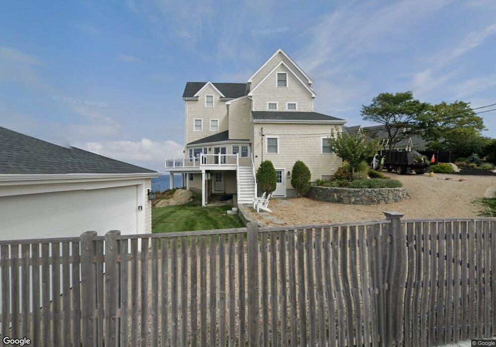
399 Atlantic Ave Unit 1 Cohasset, MA 02025
Estimated Value: $3,555,000 - $4,702,000
5
Beds
3
Baths
3,127
Sq Ft
$1,280/Sq Ft
Est. Value
About This Home
This home is located at 399 Atlantic Ave Unit 1, Cohasset, MA 02025 and is currently estimated at $4,002,438, approximately $1,279 per square foot. 399 Atlantic Ave Unit 1 is a home located in Norfolk County with nearby schools including Joseph Osgood School, Deer Hill School, and Cohasset Middle School.
Ownership History
Date
Name
Owned For
Owner Type
Purchase Details
Closed on
Feb 2, 2021
Sold by
Oneill Realty Group Llc
Bought by
Yang Xiaohui and Deng Dong
Current Estimated Value
Purchase Details
Closed on
Apr 16, 2015
Sold by
Paley Rt 1 and Nadel
Bought by
Oneill Realty Group Llc
Purchase Details
Closed on
Jan 10, 2007
Sold by
Paley Bertram R and Paley Marjorie
Bought by
Paley Bertram R and Paley Marjorie B
Create a Home Valuation Report for This Property
The Home Valuation Report is an in-depth analysis detailing your home's value as well as a comparison with similar homes in the area
Home Values in the Area
Average Home Value in this Area
Purchase History
| Date | Buyer | Sale Price | Title Company |
|---|---|---|---|
| Yang Xiaohui | $3,050,000 | None Available | |
| Yang Xiaohui | $3,050,000 | None Available | |
| Oneill Realty Group Llc | $2,300,000 | -- | |
| Oneill Realty Group Llc | $2,300,000 | -- | |
| Paley Bertram R | -- | -- | |
| Paley Bertram R | -- | -- |
Source: Public Records
Tax History
| Year | Tax Paid | Tax Assessment Tax Assessment Total Assessment is a certain percentage of the fair market value that is determined by local assessors to be the total taxable value of land and additions on the property. | Land | Improvement |
|---|---|---|---|---|
| 2025 | $38,994 | $3,367,400 | $2,624,500 | $742,900 |
| 2024 | $39,590 | $3,253,100 | $2,452,700 | $800,400 |
| 2023 | $37,274 | $3,158,800 | $2,358,400 | $800,400 |
| 2022 | $42,423 | $3,377,600 | $2,358,400 | $1,019,200 |
| 2021 | $43,035 | $3,300,200 | $2,358,400 | $941,800 |
| 2020 | $42,278 | $3,259,700 | $2,358,400 | $901,300 |
| 2019 | $42,050 | $3,259,700 | $2,358,400 | $901,300 |
| 2018 | $41,692 | $3,259,700 | $2,358,400 | $901,300 |
| 2017 | $30,977 | $2,371,900 | $1,864,500 | $507,400 |
| 2016 | $30,317 | $2,353,800 | $1,864,500 | $489,300 |
| 2015 | $29,917 | $2,353,800 | $1,864,500 | $489,300 |
| 2014 | $24,117 | $1,923,200 | $1,433,900 | $489,300 |
Source: Public Records
Map
Nearby Homes
- 104 Jerusalem Rd
- 90 Linden Dr
- 25 Mohawk Way
- 270 Forest Ave
- 93 Ripley Rd
- 572 Jerusalem Rd
- 36 Stockbridge St
- 128 Elm St Unit 313
- 4 Margin St Unit A
- 130 Forest Ave
- 124 Elm St Unit 307
- 66 Summer St
- 32 Howe Rd
- 215 Sohier St
- 147 S Main St
- 30 Diab Ln Unit 8
- 14 Cedarledge Village
- 137 Fairoaks Ln
- 98 Black Horse Ln
- 1 Bailey's Island Rd
- 399 Atlantic Ave
- WEEKLY 399 Atlantic Ave Unit 1
- 399 Atlantic Ave Unit House & Gar
- 391 Atlantic Ave
- 385 Atlantic Ave
- 385 Atlantic Ave
- 385 Atlantic Ave
- 385 Atlantic Ave
- 394 Atlantic Ave
- 400 Atlantic Ave
- 390 Atlantic Ave
- 379 Atlantic Ave
- 379 Atlantic Ave Unit 379
- 379 Atlantic Ave Unit N/A
- 380 Atlantic Ave
- 373 Atlantic Ave
- 374 Atlantic Ave
- 368 Atlantic Ave
- 369 Atlantic Ave
- 426 Atlantic Ave
Your Personal Tour Guide
Ask me questions while you tour the home.