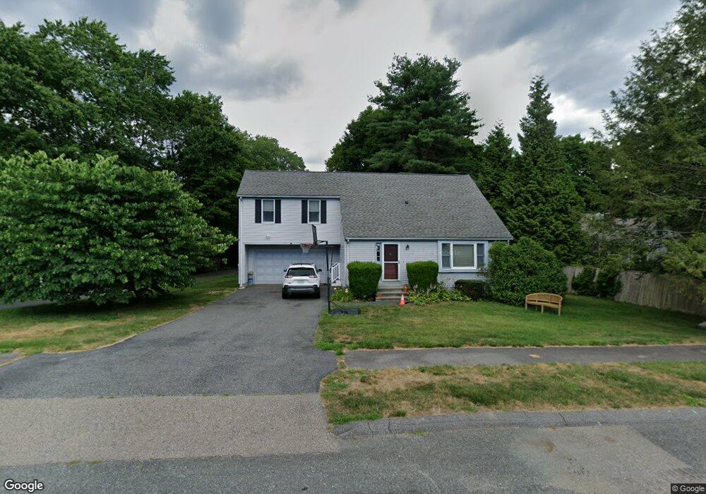
4 England Rd Natick, MA 01760
Estimated Value: $910,154 - $1,058,000
3
Beds
3
Baths
1,820
Sq Ft
$555/Sq Ft
Est. Value
About This Home
This home is located at 4 England Rd, Natick, MA 01760 and is currently estimated at $1,009,289, approximately $554 per square foot. 4 England Rd is a home located in Middlesex County with nearby schools including Natick High School, J F Kennedy Middle School, and Johnson Elementary School.
Ownership History
Date
Name
Owned For
Owner Type
Purchase Details
Closed on
Aug 13, 2003
Sold by
Traute Nicki A and Azoff Peter M
Bought by
Rosen Joel A and Rosen Stacey B
Current Estimated Value
Home Financials for this Owner
Home Financials are based on the most recent Mortgage that was taken out on this home.
Original Mortgage
$352,000
Outstanding Balance
$153,199
Interest Rate
5.46%
Mortgage Type
Purchase Money Mortgage
Estimated Equity
$856,090
Create a Home Valuation Report for This Property
The Home Valuation Report is an in-depth analysis detailing your home's value as well as a comparison with similar homes in the area
Home Values in the Area
Average Home Value in this Area
Purchase History
| Date | Buyer | Sale Price | Title Company |
|---|---|---|---|
| Rosen Joel A | $440,000 | -- |
Source: Public Records
Mortgage History
| Date | Status | Borrower | Loan Amount |
|---|---|---|---|
| Open | Rosen Joel A | $352,000 |
Source: Public Records
Tax History
| Year | Tax Paid | Tax Assessment Tax Assessment Total Assessment is a certain percentage of the fair market value that is determined by local assessors to be the total taxable value of land and additions on the property. | Land | Improvement |
|---|---|---|---|---|
| 2025 | $10,179 | $851,100 | $436,500 | $414,600 |
| 2024 | $9,824 | $801,300 | $410,800 | $390,500 |
| 2023 | $9,467 | $749,000 | $394,300 | $354,700 |
| 2022 | $9,299 | $697,100 | $357,600 | $339,500 |
| 2021 | $8,898 | $653,800 | $337,100 | $316,700 |
| 2020 | $8,690 | $638,500 | $321,800 | $316,700 |
| 2019 | $8,115 | $638,500 | $321,800 | $316,700 |
| 2018 | $7,485 | $545,400 | $306,500 | $238,900 |
| 2017 | $6,714 | $497,700 | $263,100 | $234,600 |
| 2016 | $6,438 | $474,400 | $242,100 | $232,300 |
| 2015 | $6,288 | $455,000 | $242,100 | $212,900 |
Source: Public Records
Map
Nearby Homes
- 25 Bunker Ln
- 16 Lanes End Unit 16
- 79 Speen St
- 3 Post Oak Ln Unit 8
- 8 Post Oak Ln Unit 20
- 32 Silver Hill Ln Unit 1
- 10 Village Green Ln Unit 19
- 27 Stillman St
- 74 Kendall Ave
- 47 Kendall Ave
- 7 Village Hill Ln Unit 2
- 7 Village Hill Ln Unit 4
- 5 Village Rock Ln Unit 22
- 5 Village Hill Ln Unit 19
- 15 Village Rock Ln Unit 2
- 14 Tournament Rd
- 21 Belmore Rd
- 22 Westview Rd
- 105 N Main St
- 11 Weld St Unit 37
Your Personal Tour Guide
Ask me questions while you tour the home.