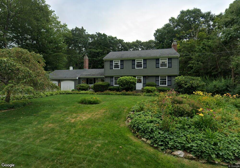
4 Squantum Rd Paxton, MA 01612
Estimated Value: $566,828 - $649,000
4
Beds
3
Baths
2,124
Sq Ft
$285/Sq Ft
Est. Value
About This Home
This home is located at 4 Squantum Rd, Paxton, MA 01612 and is currently estimated at $605,457, approximately $285 per square foot. 4 Squantum Rd is a home located in Worcester County with nearby schools including Wachusett Regional High School and Worcester Seventh-Day Adventist School.
Ownership History
Date
Name
Owned For
Owner Type
Purchase Details
Closed on
May 17, 1984
Bought by
Keegan Michael E and Keegan Joyce M
Current Estimated Value
Create a Home Valuation Report for This Property
The Home Valuation Report is an in-depth analysis detailing your home's value as well as a comparison with similar homes in the area
Home Values in the Area
Average Home Value in this Area
Purchase History
| Date | Buyer | Sale Price | Title Company |
|---|---|---|---|
| Keegan Michael E | $132,500 | -- |
Source: Public Records
Mortgage History
| Date | Status | Borrower | Loan Amount |
|---|---|---|---|
| Open | Keegan Michael E | $140,000 | |
| Closed | Keegan Michael E | $72,000 | |
| Closed | Keegan Michael E | $92,400 |
Source: Public Records
Tax History
| Year | Tax Paid | Tax Assessment Tax Assessment Total Assessment is a certain percentage of the fair market value that is determined by local assessors to be the total taxable value of land and additions on the property. | Land | Improvement |
|---|---|---|---|---|
| 2025 | $7,917 | $537,100 | $116,300 | $420,800 |
| 2024 | $7,906 | $492,000 | $116,300 | $375,700 |
| 2023 | $7,628 | $433,900 | $105,800 | $328,100 |
| 2022 | $7,334 | $386,400 | $105,800 | $280,600 |
| 2021 | $7,016 | $355,600 | $96,400 | $259,200 |
| 2020 | $6,842 | $346,800 | $87,600 | $259,200 |
| 2019 | $6,271 | $317,700 | $79,700 | $238,000 |
| 2018 | $5,631 | $275,600 | $72,300 | $203,300 |
| 2017 | $5,460 | $267,800 | $68,900 | $198,900 |
| 2016 | $5,372 | $260,900 | $68,900 | $192,000 |
| 2015 | $5,281 | $254,000 | $68,900 | $185,100 |
| 2014 | $5,115 | $249,400 | $68,900 | $180,500 |
Source: Public Records
Map
Nearby Homes
- 6 Cutler Rd
- 17 Walbridge Rd
- 78 Asnebumskit Rd
- 29 Scenic Dr
- 19 Assabet Ln
- 10 Edwidge St
- 551 Pleasant St
- 9 Forestdale Rd
- 21 Baxter St
- 21 Brewster Rd
- 16 Windemere Rd
- 9 Newburn Rd
- 620 Pleasant St
- 70 Moreland Green Dr
- 148A Tory Fort Ln
- 53 Tiverton Pkwy
- 44 Drexel St
- 306 Fisher Rd
- 5 Chartwell Ln Unit 87
- 23 Tiverton Pkwy
Your Personal Tour Guide
Ask me questions while you tour the home.