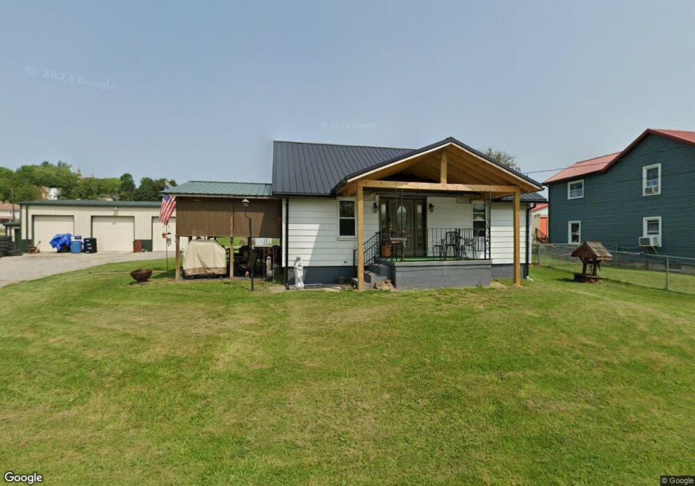
40 Unity Ave Masontown, PA 15461
Estimated Value: $79,806 - $132,000
2
Beds
1
Bath
900
Sq Ft
$108/Sq Ft
Est. Value
About This Home
This home is located at 40 Unity Ave, Masontown, PA 15461 and is currently estimated at $97,452, approximately $108 per square foot. 40 Unity Ave is a home located in Fayette County with nearby schools including Albert Gallatin Area Senior High School and All Saints Regional School.
Ownership History
Date
Name
Owned For
Owner Type
Purchase Details
Closed on
Oct 5, 2016
Sold by
Ferranti Richard A
Bought by
Corso Anthony J and Corso Tracey R
Current Estimated Value
Home Financials for this Owner
Home Financials are based on the most recent Mortgage that was taken out on this home.
Original Mortgage
$57,575
Outstanding Balance
$46,099
Interest Rate
3.42%
Mortgage Type
New Conventional
Estimated Equity
$51,354
Purchase Details
Closed on
Jan 1, 1968
Bought by
Ferranti Nancy R and Ferranti Richard A
Create a Home Valuation Report for This Property
The Home Valuation Report is an in-depth analysis detailing your home's value as well as a comparison with similar homes in the area
Home Values in the Area
Average Home Value in this Area
Purchase History
| Date | Buyer | Sale Price | Title Company |
|---|---|---|---|
| Corso Anthony J | $57,000 | None Available | |
| Ferranti Nancy R | -- | -- |
Source: Public Records
Mortgage History
| Date | Status | Borrower | Loan Amount |
|---|---|---|---|
| Open | Corso Anthony J | $57,575 |
Source: Public Records
Tax History
| Year | Tax Paid | Tax Assessment Tax Assessment Total Assessment is a certain percentage of the fair market value that is determined by local assessors to be the total taxable value of land and additions on the property. | Land | Improvement |
|---|---|---|---|---|
| 2025 | $432 | $17,720 | $4,020 | $13,700 |
| 2024 | $432 | $17,720 | $4,020 | $13,700 |
| 2023 | $863 | $17,720 | $4,020 | $13,700 |
| 2022 | $863 | $17,720 | $4,020 | $13,700 |
| 2021 | $840 | $17,720 | $4,020 | $13,700 |
| 2020 | $840 | $17,720 | $4,020 | $13,700 |
| 2019 | $796 | $17,720 | $4,020 | $13,700 |
| 2018 | $796 | $17,720 | $4,020 | $13,700 |
| 2017 | $796 | $17,720 | $4,020 | $13,700 |
| 2016 | -- | $17,720 | $4,020 | $13,700 |
| 2015 | -- | $17,720 | $4,020 | $13,700 |
| 2014 | -- | $35,440 | $8,040 | $27,400 |
Source: Public Records
Map
Nearby Homes
- 122 E Harvey Ave
- 514 S Main St
- 104 E Church Ave
- - High Ave
- 113 E Church Ave
- 2 Arlington Ave
- 431 N Main St
- 105 Central Ave
- 132 River Ave
- 534 Broadway St
- 548 N Main St
- 127 Westwood Ave
- 226 Cottage Ave
- - Sangston Ave
- 306 N 2nd St
- 1441 Leckrone Masontown Rd
- 2135 Leckrone 1 Rd
- 1892 McClellandtown Rd
- 1859 McClellandtown Rd
- 512 Leckrone Highhouse Rd
Your Personal Tour Guide
Ask me questions while you tour the home.