S
Seller's Agent in 2025
Suzie Ice
Ideal Real Estate Services, Inc.
(413) 244-2431
1 in this area
247 Total Sales
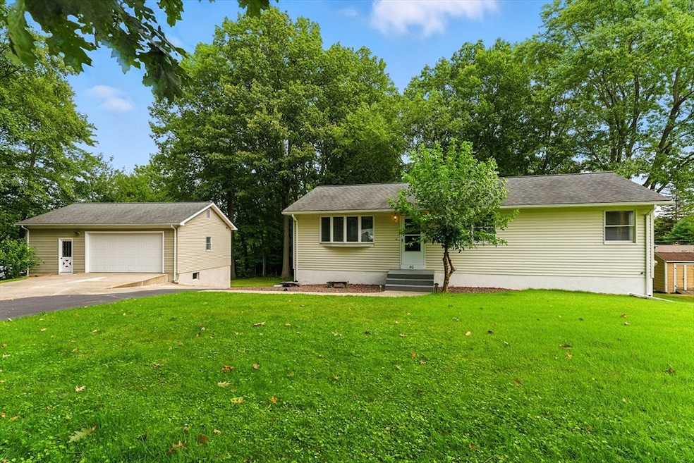
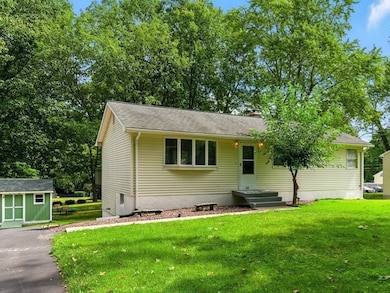
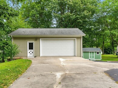


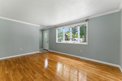
Perfectly situated at the end of a dead-end street, this well-maintained 3-bdrm ranch offers both comfort & versatility. This is not your average ranch - it comes complete w/a massive 32’x24’ detached garage, ideal for tradesmen, hobbyists, or anyone in need of serious workspace or storage. The oversized two-car garage includes a full steel-beamed lower level, providing more potential for additional parking, workshop or storage space. The home features an open floor plan, a sun-drenched living rm, hardwood floors throughout, and a spacious eat-in kitchen w/a breakfast bar & dining area that opens to the back deck — perfect for entertaining or enjoying your morning coffee. The finished walk-out bsmnt adds excellent bonus space, including a family rm, half bath, and a flexible rm that can serve as an office or 4th bdrm if needed. Whether you're looking for a move-in ready home w/extra workspace, or a unique property w/room to grow, this one checks all the boxes. Don’t miss your chance!
We collect this data history from publicly available records. To have your information removed, we recommend requesting removal directly through your county’s website.
| Date | Type | Sale Price | Title Company |
|---|---|---|---|
| Warranty Deed | $350,000 | -- | |
| Deed | $55,000 | -- | |
| Deed | $1,000 | -- |
We collect this data history from publicly available records. To have your information removed, we recommend requesting removal directly through your county’s website.
| Date | Status | Loan Amount | Loan Type |
|---|---|---|---|
| Open | $323,000 | Purchase Money Mortgage | |
| Previous Owner | $90,000 | Purchase Money Mortgage |
| Date | Event | Price | List to Sale | Price per Sq Ft |
|---|---|---|---|---|
| 10/27/2025 10/27/25 | Sold | $350,000 | +3.0% | $189 / Sq Ft |
| 09/20/2025 09/20/25 | Pending | -- | -- | -- |
| 09/15/2025 09/15/25 | For Sale | $339,900 | 0.0% | $183 / Sq Ft |
| 09/09/2025 09/09/25 | Pending | -- | -- | -- |
| 09/03/2025 09/03/25 | For Sale | $339,900 | -- | $183 / Sq Ft |
| Year | Tax Paid | Tax Assessment Tax Assessment Total Assessment is a certain percentage of the fair market value that is determined by local assessors to be the total taxable value of land and additions on the property. | Land | Improvement |
|---|---|---|---|---|
| 2025 | $4,022 | $270,500 | $102,200 | $168,300 |
| 2024 | $4,205 | $283,900 | $102,200 | $181,700 |
| 2023 | $3,978 | $256,000 | $99,900 | $156,100 |
| 2022 | $3,589 | $227,700 | $90,500 | $137,200 |
| 2021 | $3,539 | $209,400 | $84,500 | $124,900 |
| 2020 | $3,532 | $207,900 | $84,500 | $123,400 |
| 2019 | $3,526 | $207,900 | $84,500 | $123,400 |
| 2018 | $3,545 | $207,900 | $84,500 | $123,400 |
| 2017 | $3,545 | $207,900 | $84,500 | $123,400 |
| 2016 | $3,473 | $204,400 | $79,500 | $124,900 |
| 2015 | $3,403 | $200,300 | $77,800 | $122,500 |
| 2014 | $846 | $205,200 | $77,800 | $127,400 |
S
Seller's Agent in 2025
Suzie Ice
Ideal Real Estate Services, Inc.
(413) 244-2431
1 in this area
247 Total Sales
A
Buyer's Agent in 2025
Arthur Javadian
Interstate Realty Group, LLC
(413) 363-7807
10 in this area
55 Total Sales
Source: MLS Property Information Network (MLS PIN)
MLS Number: 73425645
APN: WSPR-000523-021650-R000002
Disclaimer: Certain information contained herein is derived from information provided by parties other than Homes.com. All information provided is deemed reliable, but is not guaranteed to be accurate and should be independently verified.
![]() The property listing data and information, or the Images, set forth herein were provided to MLS Property Information Network, Inc. from third party sources, including sellers, lessors and public records, and were compiled by MLS Property Information Network, Inc. The property listing data and information, and the Images, are for the personal, non-commercial use of consumers having a good faith interest in purchasing or leasing listed properties of the type displayed to them and may not be used for any purpose other than to identify prospective properties which such consumers may have a good faith interest in purchasing or leasing. MLS Property Information Network, Inc. and its subscribers disclaim any and all representations and warranties as to the accuracy of the property listing data and information, or as to the accuracy of any of the Images, set forth herein.
The property listing data and information, or the Images, set forth herein were provided to MLS Property Information Network, Inc. from third party sources, including sellers, lessors and public records, and were compiled by MLS Property Information Network, Inc. The property listing data and information, and the Images, are for the personal, non-commercial use of consumers having a good faith interest in purchasing or leasing listed properties of the type displayed to them and may not be used for any purpose other than to identify prospective properties which such consumers may have a good faith interest in purchasing or leasing. MLS Property Information Network, Inc. and its subscribers disclaim any and all representations and warranties as to the accuracy of the property listing data and information, or as to the accuracy of any of the Images, set forth herein.
Ask me questions while you tour the home.
