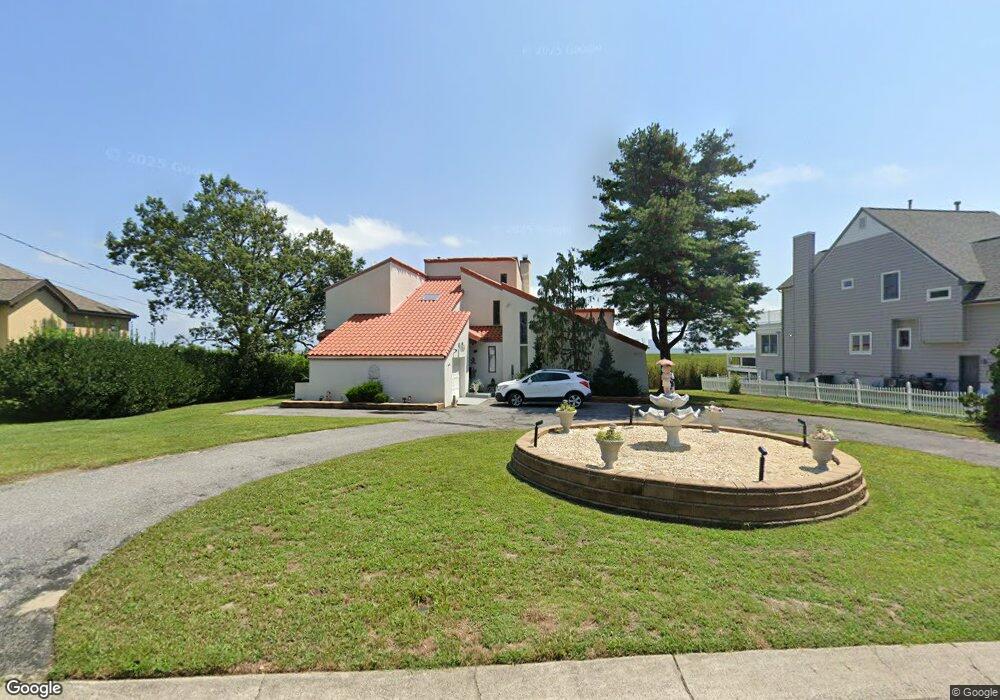
402 Burning Tree Blvd Absecon, NJ 08201
Estimated Value: $653,000 - $740,000
About This Home
This home is located at 402 Burning Tree Blvd, Absecon, NJ 08201 and is currently estimated at $697,707, approximately $214 per square foot. 402 Burning Tree Blvd is a home located in Atlantic County with nearby schools including H. Ashton Marsh Elementary School, Emma C. Attales Middle School, and Life Point Academy/ Life Point Church.
Ownership History
We collect this data history from publicly available records. To have your information removed, we recommend requesting removal directly through your county’s website.
Purchase Details
Home Financials for this Owner
Home Financials are based on the most recent Mortgage that was taken out on this home.Purchase Details
Home Financials for this Owner
Home Financials are based on the most recent Mortgage that was taken out on this home.Purchase Details
Home Financials for this Owner
Home Financials are based on the most recent Mortgage that was taken out on this home.Home Values in the Area
Average Home Value in this Area
Purchase History
We collect this data history from publicly available records. To have your information removed, we recommend requesting removal directly through your county’s website.
| Date | Buyer | Sale Price | Title Company |
|---|---|---|---|
| $460,000 | -- | ||
| $460,000 | -- | ||
| $460,000 | -- | ||
| $262,500 | The Title Company | ||
| -- | -- |
Mortgage History
We collect this data history from publicly available records. To have your information removed, we recommend requesting removal directly through your county’s website.
| Date | Status | Borrower | Loan Amount |
|---|---|---|---|
| Previous Owner | $437,000 | ||
| Previous Owner | $207,000 |
Tax History
We collect this data history from publicly available records. To have your information removed, we recommend requesting removal directly through your county’s website.
| Year | Tax Paid | Tax Assessment Tax Assessment Total Assessment is a certain percentage of the fair market value that is determined by local assessors to be the total taxable value of land and additions on the property. | Land | Improvement |
|---|---|---|---|---|
| 2025 | $11,949 | $357,100 | $130,400 | $226,700 |
| 2024 | $11,866 | $357,100 | $130,400 | $226,700 |
| 2023 | $11,806 | $357,100 | $130,400 | $226,700 |
| 2022 | $11,806 | $357,100 | $130,400 | $226,700 |
| 2021 | $11,770 | $357,100 | $130,400 | $226,700 |
| 2020 | $11,791 | $357,100 | $130,400 | $226,700 |
| 2019 | $11,706 | $357,100 | $130,400 | $226,700 |
| 2018 | $11,756 | $357,100 | $130,400 | $226,700 |
| 2017 | $11,670 | $357,100 | $130,400 | $226,700 |
| 2016 | $11,342 | $357,100 | $130,400 | $226,700 |
| 2015 | $11,195 | $357,100 | $130,400 | $226,700 |
| 2014 | $11,042 | $357,100 | $130,400 | $226,700 |
Map
- 406 Burning Tree Blvd
- 202 Burning Tree Blvd
- 203 Cynwyd Dr
- 410 4th St
- 506 Lazy Ln
- 40 N Shore Rd
- 3 Stone Cir
- 619 4th St
- 137 E Wyoming Ave
- 101 W Church St
- 107 W Church St
- 144 Pitney Rd
- 157 E Wyoming Ave
- 15 W Bolton Ave
- 110 Pennsylvania Ave
- 140 Pennsylvania Ave
- 4 E Curran Dr
- 244 E Wyoming Ave
- 48 W Bolton Ave
- 224 Huron Ave
- 404 Burning Tree Blvd
- 400 Burning Tree Blvd
- 503 Burning Tree Blvd
- 403 Burning Tree Blvd
- 401 Burning Tree Blvd
- 407 Burning Tree Blvd
- 408 Burning Tree Blvd
- 399 Burning Tree Blvd
- 404 Cynwyd Dr
- 402 Cynwyd Dr
- 719 Birch Cir
- 406 Cynwyd Dr
- 111 Cedar Hill Dr
- 410 Burning Tree Blvd
- 308 Cynwyd Dr
- 305 Burning Tree Blvd
- 302 Burning Tree Blvd
- 408 Cynwyd Dr
- 306 Cynwyd Dr
- 403 Cynwyd Dr
Ask me questions while you tour the home.