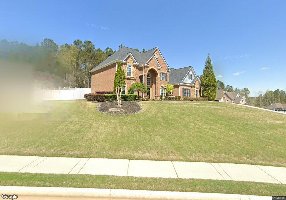
402 Rivermist Ct Bethlehem, GA 30620
Estimated Value: $556,000 - $676,000
4
Beds
4
Baths
3,956
Sq Ft
$155/Sq Ft
Est. Value
About This Home
This home is located at 402 Rivermist Ct, Bethlehem, GA 30620 and is currently estimated at $611,509, approximately $154 per square foot. 402 Rivermist Ct is a home located in Walton County with nearby schools including Walker Park Elementary School, Carver Middle School, and Monroe Area High School.
Ownership History
Date
Name
Owned For
Owner Type
Purchase Details
Closed on
Jun 25, 2007
Sold by
Castle Grp Hms Of Gwinnett Llc
Bought by
Cook Robert L
Current Estimated Value
Home Financials for this Owner
Home Financials are based on the most recent Mortgage that was taken out on this home.
Original Mortgage
$340,900
Outstanding Balance
$206,231
Interest Rate
6.16%
Mortgage Type
New Conventional
Estimated Equity
$405,278
Create a Home Valuation Report for This Property
The Home Valuation Report is an in-depth analysis detailing your home's value as well as a comparison with similar homes in the area
Home Values in the Area
Average Home Value in this Area
Purchase History
| Date | Buyer | Sale Price | Title Company |
|---|---|---|---|
| Cook Robert L | $426,200 | -- |
Source: Public Records
Mortgage History
| Date | Status | Borrower | Loan Amount |
|---|---|---|---|
| Open | Cook Robert L | $340,900 |
Source: Public Records
Tax History
| Year | Tax Paid | Tax Assessment Tax Assessment Total Assessment is a certain percentage of the fair market value that is determined by local assessors to be the total taxable value of land and additions on the property. | Land | Improvement |
|---|---|---|---|---|
| 2025 | $2,121 | $238,240 | $32,000 | $206,240 |
| 2024 | $1,821 | $233,040 | $32,000 | $201,040 |
| 2023 | $5,012 | $207,360 | $30,000 | $177,360 |
| 2022 | $5,372 | $185,920 | $23,600 | $162,320 |
| 2021 | $5,055 | $162,200 | $20,000 | $142,200 |
| 2020 | $5,006 | $153,920 | $18,000 | $135,920 |
| 2019 | $4,854 | $147,280 | $18,000 | $129,280 |
| 2018 | $4,858 | $147,280 | $18,000 | $129,280 |
| 2017 | $4,842 | $140,520 | $18,000 | $122,520 |
| 2016 | $4,659 | $138,240 | $18,000 | $120,240 |
| 2015 | $4,071 | $119,040 | $16,000 | $103,040 |
| 2014 | $4,135 | $117,960 | $0 | $0 |
Source: Public Records
Map
Nearby Homes
- 3499 Chota Ln
- 2379 Tomoka Dr
- 2524 Tomoka Dr
- 1908 Enota Dr
- 1615 Newport Dr
- 5259 June Ivey Rd NW
- 2729 Eva Ct SE
- 1978 Waterside Cir
- 215 Apalachee Dr
- 1323 Hudson Ct
- 1130 Lyndhurst Ln
- 8345 Shadow Creek Dr
- 8255 Shadow Creek Dr
- 30 Silverleaf Trail
- 78 Silverleaf Trail
- 92 Silverleaf Trail
- 104 Silverleaf Trail
- 120 Silverleaf Trail
- 99 Silverleaf Trail
- 280 Silverleaf Trail
- 406 Rivermist Ct
- 258 Ivey Dr Unit 37
- 258 Ivey Dr
- 401 Rivermist Ct
- 401 Rivermist Ct Unit 28
- 254 Ivey Dr Unit 38
- 254 Ivey Dr
- 265 Ivey Dr
- 261 Ivey Dr
- 410 Rivermist Ct
- 253 Ivey Dr
- 253 Ivey Dr Unit 14
- 250 Ivey Dr Unit 39
- 250 Ivey Dr
- 250 250 Ivey Unit 39
- 409 Rivermist Ct
- 409 Rivermist Ct Unit 29
- 269 Ivey Dr
- 602 River Cove Ct
- 249 Ivey Dr Unit 13
Your Personal Tour Guide
Ask me questions while you tour the home.