Estimated Value: $218,000 - $249,000
Studio
--
Bath
--
Sq Ft
30,492
Sq Ft Lot
About This Home
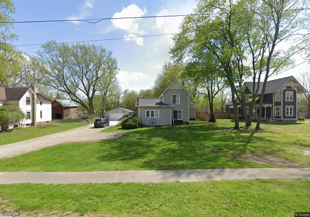
This home is located at 407 W Maple St, Byron, MI 48418 and is currently estimated at $233,712. 407 W Maple St is a home located in Shiawassee County with nearby schools including Byron Area Elementary School, Byron Area Middle School, and Byron Area High School.
Ownership History
Date
Name
Owned For
Owner Type
Purchase Details
Closed on
May 29, 2009
Sold by
Shea Corey J
Bought by
Simmet Robert D
Current Estimated Value
Home Financials for this Owner
Home Financials are based on the most recent Mortgage that was taken out on this home.
Original Mortgage
$68,732
Outstanding Balance
$43,566
Interest Rate
4.83%
Mortgage Type
FHA
Estimated Equity
$190,146
Purchase Details
Closed on
May 13, 2005
Sold by
Wolfe Edward C and Wolfe Jerriann E
Bought by
Kurtz Ryan and Dominick Emily
Home Financials for this Owner
Home Financials are based on the most recent Mortgage that was taken out on this home.
Original Mortgage
$113,600
Interest Rate
6.05%
Mortgage Type
Fannie Mae Freddie Mac
Purchase Details
Closed on
Jan 19, 2005
Sold by
Wolfe Edward C and Wolfe Jerriann E
Bought by
Bank Of America Na
Create a Home Valuation Report for This Property
The Home Valuation Report is an in-depth analysis detailing your home's value as well as a comparison with similar homes in the area
Purchase History
| Date | Buyer | Sale Price | Title Company |
|---|---|---|---|
| Simmet Robert D | $70,000 | -- | |
| Kurtz Ryan | $142,000 | First American Title | |
| Bank Of America Na | $66,401 | -- |
Source: Public Records
Mortgage History
| Date | Status | Borrower | Loan Amount |
|---|---|---|---|
| Open | Simmet Robert D | $68,732 | |
| Previous Owner | Kurtz Ryan | $113,600 | |
| Closed | Kurtz Ryan | $28,400 |
Source: Public Records
Tax History
| Year | Tax Paid | Tax Assessment Tax Assessment Total Assessment is a certain percentage of the fair market value that is determined by local assessors to be the total taxable value of land and additions on the property. | Land | Improvement |
|---|---|---|---|---|
| 2025 | $1,568 | $126,500 | $0 | $0 |
| 2024 | $1,495 | $106,000 | $0 | $0 |
| 2023 | $611 | $97,100 | $0 | $0 |
| 2022 | $2,030 | $95,000 | $0 | $0 |
| 2021 | $1,765 | $82,200 | $0 | $0 |
| 2020 | $1,739 | $73,000 | $0 | $0 |
| 2019 | $1,722 | $51,500 | $0 | $0 |
| 2018 | $1,684 | $50,400 | $0 | $0 |
| 2017 | $1,622 | $45,800 | $0 | $0 |
| 2016 | -- | $45,800 | $0 | $0 |
| 2015 | -- | $45,500 | $0 | $0 |
| 2014 | $6 | $44,000 | $0 | $0 |
Source: Public Records
Map
Nearby Homes
- 211 N Church St
- 215 Washington St
- 11250 S New Lothrop Rd
- vl Lehring Rd
- 00 Lehring and Britton Roads
- Parcel E Turkey Trail
- Parcel F Turkey Trail
- Parcel D Turkey Trail
- 206 Emmett
- 12102 Rolston Rd
- 0 Williams Rd
- 7960 Beard Rd
- 14830 County Line Rd
- 0 Lovejoy Rd Unit 20261017550
- 8875 E Miller Rd
- 11036 Charles Dr
- 11035 Charles Dr
- 11012 Duffield Rd
- Pine Knob Rd Lot Unit WP001
- 14408 McCaslin Lake Rd
Your Personal Tour Guide
Ask me questions while you tour the home.