4076 Mapes Dr Brunswick, OH 44212
Estimated Value: $219,729 - $243,000
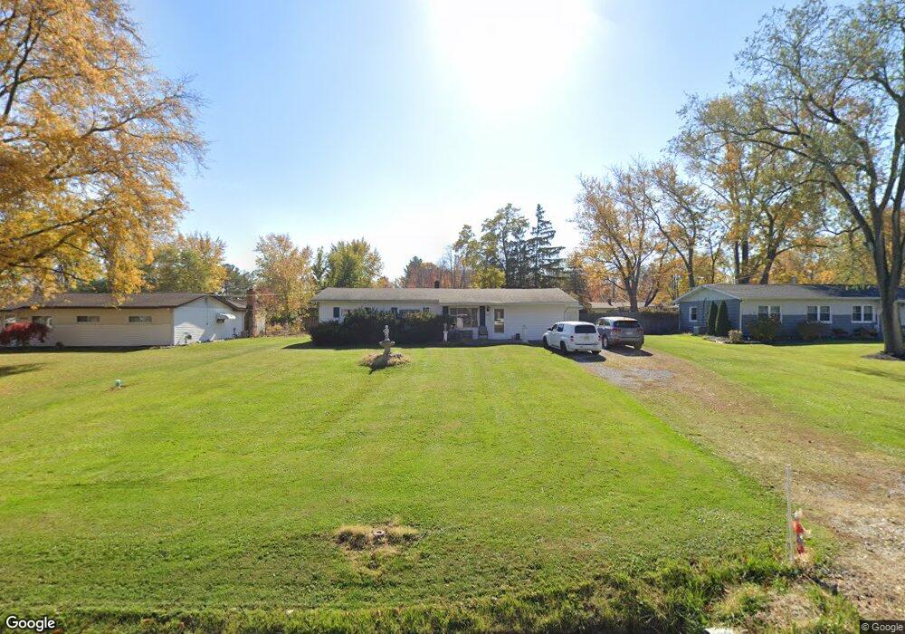
About This Home
This home is located at 4076 Mapes Dr, Brunswick, OH 44212 and is currently estimated at $234,432, approximately $187 per square foot. 4076 Mapes Dr is a home located in Medina County with nearby schools including Applewood Elementary School, Willets Middle School, and Brunswick High School.
Ownership History
We collect this data history from publicly available records. To have your information removed, we recommend requesting removal directly through your county’s website.
Purchase Details
Purchase Details
Purchase Details
Home Values in the Area
Average Home Value in this Area
Purchase History
We collect this data history from publicly available records. To have your information removed, we recommend requesting removal directly through your county’s website.
| Date | Buyer | Sale Price | Title Company |
|---|---|---|---|
| -- | Cardinal Title Co Ohio Inc | ||
| -- | -- | ||
| -- | Guardian Title |
Tax History
We collect this data history from publicly available records. To have your information removed, we recommend requesting removal directly through your county’s website.
| Year | Tax Paid | Tax Assessment Tax Assessment Total Assessment is a certain percentage of the fair market value that is determined by local assessors to be the total taxable value of land and additions on the property. | Land | Improvement |
|---|---|---|---|---|
| 2025 | $2,935 | $62,900 | $27,300 | $35,600 |
| 2024 | $2,935 | $52,880 | $23,810 | $29,070 |
| 2023 | $2,130 | $52,880 | $23,810 | $29,070 |
| 2022 | $2,064 | $52,880 | $23,810 | $29,070 |
| 2021 | $1,733 | $41,970 | $18,900 | $23,070 |
| 2020 | $1,559 | $41,970 | $18,900 | $23,070 |
| 2019 | $1,560 | $41,970 | $18,900 | $23,070 |
| 2018 | $1,283 | $34,670 | $16,400 | $18,270 |
| 2017 | $1,285 | $34,670 | $16,400 | $18,270 |
| 2016 | $1,284 | $34,670 | $16,400 | $18,270 |
| 2015 | $1,195 | $32,100 | $15,180 | $16,920 |
| 2014 | $1,191 | $32,100 | $15,180 | $16,920 |
| 2013 | $1,165 | $32,100 | $15,180 | $16,920 |
Map
- 4060 Laurel Rd
- 1751 Clemson Dr
- 4165 Raymond Dr
- 1622 Diana Dr
- 3960 Marie Dr
- 1528 Diana Dr
- 3841 Laurel Rd
- 4267 Western Reserve Dr
- 1740 Maxwell Blvd
- 4206 Arlington Dr
- 1591 Pearl Rd
- 4516 Chaseline Ridge
- 4316 Arlington Dr
- 3762 Laurel Rd
- 3772 Selma Ln
- 1973 Pinewood Dr
- 4247 Shalbey Trail
- 1445 Andrea Dr
- 4419 Lockmoor Ln
- 2073 Glenmont
- 4068 Mapes Dr
- 4086 Mapes Dr
- 4077 Laurel Rd
- 1732 Britnall Dr
- 4096 Mapes Dr
- 4067 Laurel Rd
- 4085 Laurel Rd
- 1732 Brintnall Dr
- 1733 Dannley Dr
- 4095 Laurel Rd
- 4104 Mapes Dr
- 1724 Brintnall Dr
- 1755 Brintnall Dr
- 1747 Brintnall Dr
- 4053 Laurel Rd
- 1725 Dannley Dr
- 4105 Laurel Rd
- 1737 Brintnall Dr
- 4114 Mapes Dr
- 4045 Laurel Rd
Ask me questions while you tour the home.