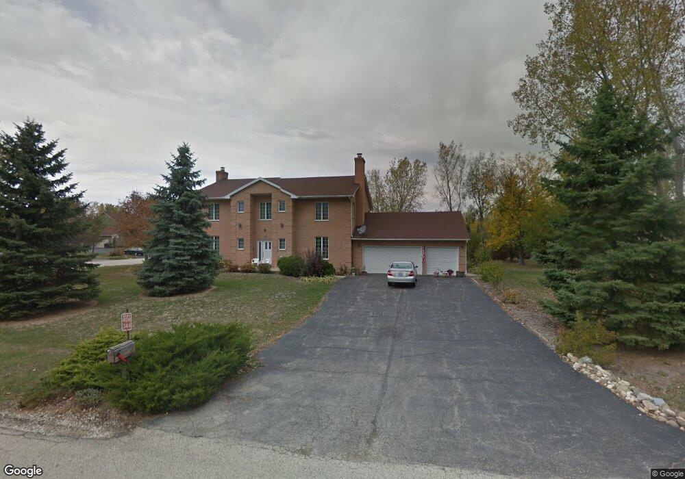
40W344 Apache Ln Huntley, IL 60142
Estimated Value: $493,000 - $686,000
Studio
1
Bath
4,212
Sq Ft
$142/Sq Ft
Est. Value
About This Home
This home is located at 40W344 Apache Ln, Huntley, IL 60142 and is currently estimated at $598,752, approximately $142 per square foot. 40W344 Apache Ln is a home located in Kane County with nearby schools including Gilberts Elementary School, Dundee Middle School, and Hampshire High School.
Ownership History
Date
Name
Owned For
Owner Type
Purchase Details
Closed on
Sep 7, 2022
Sold by
Mercuri Elia
Bought by
Elia Mercuri Living Trust and Mercuri
Current Estimated Value
Create a Home Valuation Report for This Property
The Home Valuation Report is an in-depth analysis detailing your home's value as well as a comparison with similar homes in the area
Home Values in the Area
Average Home Value in this Area
Purchase History
| Date | Buyer | Sale Price | Title Company |
|---|---|---|---|
| Elia Mercuri Living Trust | -- | None Listed On Document |
Source: Public Records
Tax History
| Year | Tax Paid | Tax Assessment Tax Assessment Total Assessment is a certain percentage of the fair market value that is determined by local assessors to be the total taxable value of land and additions on the property. | Land | Improvement |
|---|---|---|---|---|
| 2024 | $11,672 | $180,291 | $23,081 | $157,210 |
| 2023 | $4,998 | $163,042 | $20,873 | $142,169 |
| 2022 | $5,502 | $150,325 | $19,245 | $131,080 |
| 2021 | $9,689 | $141,389 | $18,101 | $123,288 |
| 2020 | $5,777 | $137,779 | $17,639 | $120,140 |
| 2019 | $5,872 | $132,239 | $16,930 | $115,309 |
| 2018 | $6,063 | $124,110 | $15,889 | $108,221 |
| 2017 | $8,634 | $118,189 | $15,131 | $103,058 |
| 2016 | $6,470 | $112,518 | $14,405 | $98,113 |
| 2015 | -- | $106,269 | $13,605 | $92,664 |
| 2014 | -- | $100,210 | $17,278 | $82,932 |
| 2013 | -- | $102,047 | $17,595 | $84,452 |
Source: Public Records
Map
Nearby Homes
- 18N647 Ridgefield Blvd
- 959 Sunburst Ln
- 918 Glacial Falls Dr
- 10558 Yellowstone Dr
- Lot 29 Ryann Rd
- lot 36 Ryann Rd
- 11061 Bayou Ct
- 11703 Barberry Ct
- 12175 Quail Ridge Dr
- Lot 277033 Galligan Rd
- Lot 480017 Galligan Rd
- Lot 499001 Galligan Rd
- 70 acres Galligan Rd
- Lot 230001 Galligan Rd
- 12178 White Tail Ln
- 12126 White Tail Ln
- 13664 Windy Prairie Dr
- 12230 Songbird Ln
- 38W715 Huntley Rd
- 12773 Horseshoe Trail
- 40W322 Apache Ln
- 40W339 Baron Ln
- 18N816 Aztec Ln
- 40W323 Baron Ln
- 18N840 Aztec Ln
- 40W294 Apache Ln
- 18N780 Aztec Ln
- 40W345 Apache Ln
- 40W321 Apache Ln
- 40W301 Baron Ln
- 18N858 Aztec Ln
- 40W297 Apache Ln
- 18N886 Aztec Ln
- 40W260 Apache Ln
- 40W283 Baron Ln
- 40W420 Apache Ln Unit 1
- 42 Apache Ln
- 18N839 Barko Pkwy Unit 1
- 40W320 Baron Ln
- 40W263 Apache Ln
Your Personal Tour Guide
Ask me questions while you tour the home.