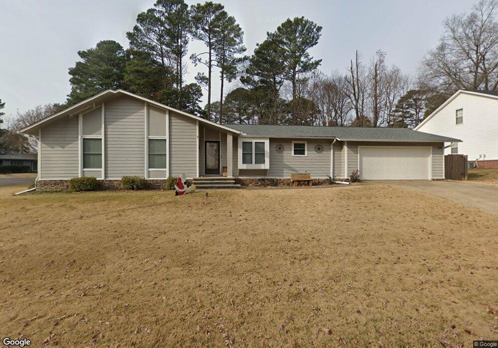
4114 Ginger Dr Benton, AR 72019
Estimated Value: $199,000 - $250,000
Studio
2
Baths
1,674
Sq Ft
$129/Sq Ft
Est. Value
About This Home
This home is located at 4114 Ginger Dr, Benton, AR 72019 and is currently estimated at $215,756, approximately $128 per square foot. 4114 Ginger Dr is a home located in Saline County with nearby schools including Perrin Elementary School, Benton Middle School, and Benton Junior High School.
Ownership History
Date
Name
Owned For
Owner Type
Purchase Details
Closed on
Apr 6, 2005
Sold by
Penn Jefferson R and Penn Maria Lynne
Bought by
Dawson David E and Dawson Katherine J
Current Estimated Value
Home Financials for this Owner
Home Financials are based on the most recent Mortgage that was taken out on this home.
Original Mortgage
$114,000
Outstanding Balance
$58,829
Interest Rate
5.78%
Mortgage Type
New Conventional
Estimated Equity
$156,927
Purchase Details
Closed on
Dec 8, 1999
Bought by
Penn
Create a Home Valuation Report for This Property
The Home Valuation Report is an in-depth analysis detailing your home's value as well as a comparison with similar homes in the area
Home Values in the Area
Average Home Value in this Area
Purchase History
| Date | Buyer | Sale Price | Title Company |
|---|---|---|---|
| Dawson David E | $127,000 | -- | |
| Penn | $110,000 | -- |
Source: Public Records
Mortgage History
| Date | Status | Borrower | Loan Amount |
|---|---|---|---|
| Open | Dawson David E | $114,000 |
Source: Public Records
Tax History
| Year | Tax Paid | Tax Assessment Tax Assessment Total Assessment is a certain percentage of the fair market value that is determined by local assessors to be the total taxable value of land and additions on the property. | Land | Improvement |
|---|---|---|---|---|
| 2025 | $1,942 | $36,750 | $6,000 | $30,750 |
| 2024 | $1,987 | $36,750 | $6,000 | $30,750 |
| 2023 | $1,433 | $36,750 | $6,000 | $30,750 |
| 2022 | $1,398 | $36,750 | $6,000 | $30,750 |
| 2021 | $1,314 | $30,490 | $4,600 | $25,890 |
| 2020 | $1,207 | $30,490 | $4,600 | $25,890 |
| 2019 | $1,207 | $30,490 | $4,600 | $25,890 |
| 2018 | $1,160 | $30,490 | $4,600 | $25,890 |
| 2017 | $1,092 | $30,490 | $4,600 | $25,890 |
| 2016 | $1,408 | $24,830 | $4,600 | $20,230 |
| 2015 | $1,393 | $24,830 | $4,600 | $20,230 |
| 2014 | $1,043 | $24,830 | $4,600 | $20,230 |
Source: Public Records
Map
Nearby Homes
- 1702 Glenda Ln
- 3913 Sandra Ln
- 2023 Longhills Rd E
- 1800 Fox Trail
- 20 Acres Congo Rd
- 3519 Pelton
- 1971 Scott Salem Rd
- 1710 Troy Cir
- 3505 Pelton
- 1120 Grand Teton Dr
- 1906 Deerfield
- 1122 Grand Teton Dr
- 1108 Grand Teton Dr
- 1104 Grand Teton Dr
- 1204 Beaverhead Cove
- 3221 Drake Dr
- 913 Grand Teton Dr
- 909 Grand Teton Dr
- 18 Summerwood Dr
- 542 Scarlet Oaks Dr
- 4202 Ginger Dr
- 4110 Ginger Cove
- 4108 Ginger Cove
- 4206 Ginger Dr
- 4113 Ginger Dr
- 4102 Ginger Dr
- 4205 Ginger Dr
- 4210 Ginger Dr
- 4209 Ginger Dr
- 4000 Ginger Dr
- 4107 Sandra Ln
- 4105 Sandra Ln
- 4211 Glenda Ln
- 4111 Sandra Ln
- 4103 Sandra Ln
- 4218 Ginger Dr
- 4101 Ginger Dr
- 4215 Ginger Dr
- 4113 Sandra Ln
- 4016 Ginger Dr
Your Personal Tour Guide
Ask me questions while you tour the home.