Estimated Value: $135,000 - $421,000
About This Home
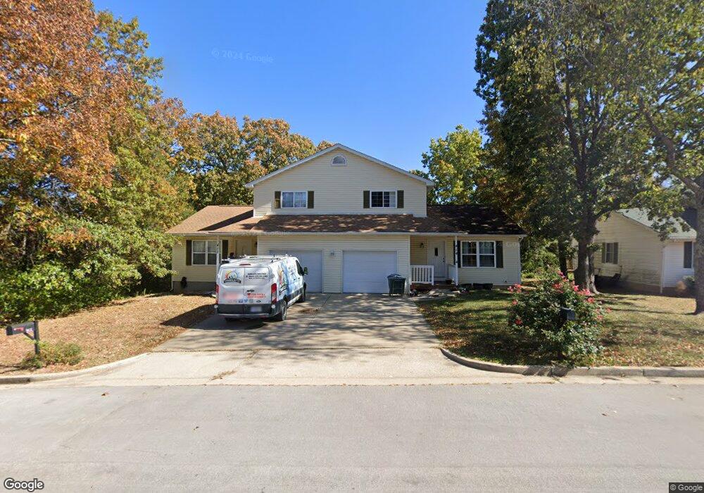
This home is located at 412 Curtis Dr Unit 414, Rolla, MO 65401 and is currently estimated at $256,340, approximately $258 per square foot. 412 Curtis Dr Unit 414 is a home located in Phelps County with nearby schools including Rolla Junior High School, Rolla Senior High School, and Rolla Seventh-Day Adventist School.
Ownership History
We collect this data history from publicly available records. To have your information removed, we recommend requesting removal directly through your county’s website.
Purchase Details
Home Financials for this Owner
Home Financials are based on the most recent Mortgage that was taken out on this home.Home Values in the Area
Average Home Value in this Area
Purchase History
We collect this data history from publicly available records. To have your information removed, we recommend requesting removal directly through your county’s website.
| Date | Buyer | Sale Price | Title Company |
|---|---|---|---|
| $343,750 | South Ctrl Land Title |
Mortgage History
We collect this data history from publicly available records. To have your information removed, we recommend requesting removal directly through your county’s website.
| Date | Status | Borrower | Loan Amount |
|---|---|---|---|
| Open | $275,000 |
Tax History
We collect this data history from publicly available records. To have your information removed, we recommend requesting removal directly through your county’s website.
| Year | Tax Paid | Tax Assessment Tax Assessment Total Assessment is a certain percentage of the fair market value that is determined by local assessors to be the total taxable value of land and additions on the property. | Land | Improvement |
|---|---|---|---|---|
| 2025 | $1,955 | $37,460 | $4,100 | $33,360 |
| 2024 | $1,794 | $33,370 | $3,040 | $30,330 |
| 2023 | $1,805 | $33,370 | $3,040 | $30,330 |
| 2022 | $1,533 | $33,370 | $3,040 | $30,330 |
| 2021 | $1,544 | $33,370 | $3,040 | $30,330 |
| 2020 | $1,394 | $29,410 | $3,040 | $26,370 |
| 2019 | $1,386 | $29,410 | $3,040 | $26,370 |
| 2018 | $1,374 | $29,410 | $3,040 | $26,370 |
| 2017 | $1,372 | $29,410 | $3,040 | $26,370 |
| 2016 | $1,327 | $29,410 | $3,040 | $26,370 |
| 2015 | -- | $29,410 | $3,040 | $26,370 |
| 2014 | -- | $29,410 | $3,040 | $26,370 |
| 2013 | -- | $29,410 | $0 | $0 |
Map
- 621 Scottsvale Dr
- 622 Scottsvale Dr
- 8 Peachtree Ln
- 106 Steeplechase Rd
- 206 Brookridge Dr
- 115 Belmont Dr
- 1344 E State Route 72
- 32 Sydney Ct
- 17 Mcfarland Dr
- 1606 Pilgrim Place
- 1702 & 1708 E Hwy 72
- 1599 E State Route 72
- 905 Hampton Ct
- 307 Lovers Ln
- 405 Bill Ave
- 1112 Sycamore Dr
- 1308 Highland Dr
- 1108 Mimosa Ct
- Lot 74 B Cedar Hill Ct
- Lot 74 A Cedar Hill Ct
- 412-414 Curtis Dr Unit 412
- 500 Curtis Dr Unit 502
- 501 Sherwood Dr Unit 503
- 507 Cheswick Ct
- 509 Cheswick Ct
- 504 Curtis Dr Unit 506
- 505 Cheswick Ct
- 503 Canterbury Ct Unit A
- 503A Canterbury Ct
- 0 Sherwood Unit 15022353
- 0 Sherwood Unit 24003216
- 600 Curtis Dr Unit 602
- 500 Sherwood Dr
- 500 Sherwood Dr Unit A
- 0 Curtis & Richard
- 508 Cheswick Ct
- 506 Cheswick Ct
- 604 Curtis Dr Unit 606
- 510 Cheswick Ct
- 513 Cheswick Ct
Ask me questions while you tour the home.