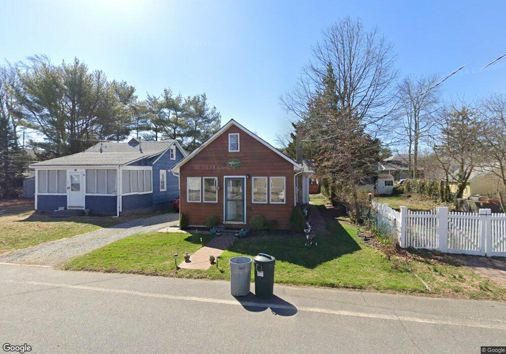
412 E Long Branch Ave Ocean Gate, NJ 08740
Estimated Value: $282,958 - $337,000
2
Beds
1
Bath
660
Sq Ft
$481/Sq Ft
Est. Value
About This Home
This home is located at 412 E Long Branch Ave, Ocean Gate, NJ 08740 and is currently estimated at $317,240, approximately $480 per square foot. 412 E Long Branch Ave is a home located in Ocean County with nearby schools including Ocean Gate Elementary School, Central Regional Middle School, and Central Regional High School.
Ownership History
Date
Name
Owned For
Owner Type
Purchase Details
Closed on
Nov 19, 2004
Sold by
Finch Mabel
Bought by
Ruprecht Stephen
Current Estimated Value
Home Financials for this Owner
Home Financials are based on the most recent Mortgage that was taken out on this home.
Original Mortgage
$76,000
Interest Rate
5.66%
Mortgage Type
Fannie Mae Freddie Mac
Purchase Details
Closed on
Sep 8, 1987
Bought by
Finch Thomas and Finch Mable
Create a Home Valuation Report for This Property
The Home Valuation Report is an in-depth analysis detailing your home's value as well as a comparison with similar homes in the area
Home Values in the Area
Average Home Value in this Area
Purchase History
| Date | Buyer | Sale Price | Title Company |
|---|---|---|---|
| Ruprecht Stephen | $80,000 | Fidelity Natl Title Ins Co | |
| Finch Thomas | $72,000 | -- |
Source: Public Records
Mortgage History
| Date | Status | Borrower | Loan Amount |
|---|---|---|---|
| Previous Owner | Ruprecht Stephen | $76,000 |
Source: Public Records
Tax History
| Year | Tax Paid | Tax Assessment Tax Assessment Total Assessment is a certain percentage of the fair market value that is determined by local assessors to be the total taxable value of land and additions on the property. | Land | Improvement |
|---|---|---|---|---|
| 2025 | $4,509 | $247,600 | $146,000 | $101,600 |
| 2024 | $3,674 | $247,600 | $146,000 | $101,600 |
| 2023 | $3,384 | $121,700 | $60,700 | $61,000 |
| 2022 | $3,384 | $121,700 | $60,700 | $61,000 |
| 2021 | $3,240 | $121,700 | $60,700 | $61,000 |
| 2020 | $3,265 | $121,700 | $60,700 | $61,000 |
| 2019 | $3,186 | $121,700 | $60,700 | $61,000 |
| 2018 | $3,075 | $121,700 | $60,700 | $61,000 |
| 2017 | $3,052 | $121,700 | $60,700 | $61,000 |
| 2016 | $3,028 | $121,700 | $60,700 | $61,000 |
| 2015 | $3,287 | $161,300 | $100,000 | $61,300 |
| 2014 | $3,302 | $161,300 | $100,000 | $61,300 |
Source: Public Records
Map
Nearby Homes
- 319 Monmouth Ave
- 521 E Long Branch Ave
- 318 E Cape May Ave
- 409 Newport Ave
- 601 E Arverne Ave
- 129 E Long Branch Ave
- 639 E Bayview Ave
- 723 E Long Branch Ave
- 37 E Lakewood Ave
- 32 E Long Branch Ave
- 207 Ocean Gate Ave
- 15 W Arverne Ave
- 24 W Point Pleasant Ave
- 46 W Cape May Ave
- 707 Navesink Ave
- 553 Ocean Gate Dr
- 117 W Arverne Ave
- 0 Jane Ave
- 2 Jane Ave
- 3 Sheila Ct
- 414 E Long Branch Ave
- 601 Monmouth Ave
- 605 Monmouth Ave
- 611 Monmouth Ave
- 413 E Point Pleasant Ave
- 421 E Point Pleasant Ave
- 418 E Long Branch Ave
- 519 Monmouth Ave
- 619 Monmouth Ave
- 415 E Long Branch Ave
- 419 E Long Branch Ave
- 435 E Point Pleasant Ave
- 509 Monmouth Ave
- 425 E Long Branch Ave
- 600 Monmouth Ave
- 614 Monmouth Ave
- 429 E Long Branch Ave
- 437 E Point Pleasant Ave
- 414 E Lakewood Ave
- 514 Monmouth Ave
Your Personal Tour Guide
Ask me questions while you tour the home.