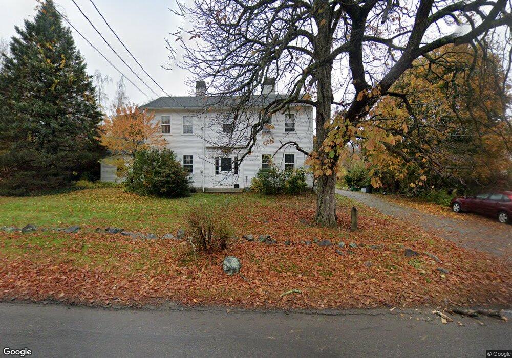
419 Central St Rowley, MA 01969
Estimated Value: $742,435 - $947,000
About This Home
This home is located at 419 Central St, Rowley, MA 01969 and is currently estimated at $883,859, approximately $313 per square foot. 419 Central St is a home located in Essex County with nearby schools including Triton Regional High School, North Shore Montessori School, and Clark School.
Ownership History
We collect this data history from publicly available records. To have your information removed, we recommend requesting removal directly through your county’s website.
Purchase Details
Home Values in the Area
Average Home Value in this Area
Purchase History
We collect this data history from publicly available records. To have your information removed, we recommend requesting removal directly through your county’s website.
| Date | Buyer | Sale Price | Title Company |
|---|---|---|---|
| $47,500 | -- |
Mortgage History
We collect this data history from publicly available records. To have your information removed, we recommend requesting removal directly through your county’s website.
| Date | Status | Borrower | Loan Amount |
|---|---|---|---|
| Open | $172,000 | ||
| Closed | $100,000 |
Tax History
We collect this data history from publicly available records. To have your information removed, we recommend requesting removal directly through your county’s website.
| Year | Tax Paid | Tax Assessment Tax Assessment Total Assessment is a certain percentage of the fair market value that is determined by local assessors to be the total taxable value of land and additions on the property. | Land | Improvement |
|---|---|---|---|---|
| 2025 | $8,221 | $698,500 | $312,600 | $385,900 |
| 2024 | $8,125 | $671,500 | $297,700 | $373,800 |
| 2023 | $7,436 | $571,100 | $257,600 | $313,500 |
| 2022 | $7,192 | $491,900 | $214,500 | $277,400 |
| 2021 | $6,980 | $448,000 | $187,500 | $260,500 |
| 2020 | $6,737 | $432,400 | $179,100 | $253,300 |
| 2019 | $6,171 | $420,400 | $179,100 | $241,300 |
| 2018 | $5,918 | $405,900 | $179,100 | $226,800 |
| 2017 | $5,739 | $405,900 | $179,100 | $226,800 |
| 2016 | $5,524 | $384,700 | $155,500 | $229,200 |
| 2015 | $5,307 | $372,700 | $155,500 | $217,200 |
Map
- 601 Newburyport Turnpike
- 304-312 + Wetherfield St Nbpt Turnpike
- 304 & 480 Wethersfield St & Nbpt Tnpk
- 87 Elm St
- 21 Greentree Ln
- 60 Caldwell Farm Rd
- 54 Wild Pasture Ln
- 215 Wethersfield St
- 1 Confidential Way
- 399 Wethersfield St
- 439 Wethersfield St
- 312 Wethersfield St
- 27 Greentree Ln
- 23 Oak Ledge Cir
- 413 Wethersfield St
- 11 Arthur Gordon Dr
- 117 Kittery Ave
- 32 School St
- 29 Orchard St
- 164 Main St Unit 9
- 422 Central St
- 418 Central St
- 426 Central St
- 428 Central St
- 414 Central St
- 414 Central St Unit 1
- 441 Central St
- 430 Central St
- 429 Central St
- 613 Newburyport Turnpike
- 398 Central St
- 2 Glen St
- 395 Central St
- 396 Central St
- 389 Central St
- 15 Glen St
- 8 Glen St
- 385 Central St
- 609 Newburyport Turnpike
- 388 Central St
Ask me questions while you tour the home.