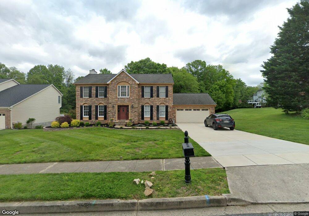
421 E Ring Factory Rd Bel Air, MD 21014
Estimated Value: $495,000 - $616,000
Studio
3
Baths
2,432
Sq Ft
$225/Sq Ft
Est. Value
About This Home
This home is located at 421 E Ring Factory Rd, Bel Air, MD 21014 and is currently estimated at $547,223, approximately $225 per square foot. 421 E Ring Factory Rd is a home located in Harford County with nearby schools including Homestead-Wakefield Elementary School, Bel Air Middle School, and Bel Air High School.
Ownership History
Date
Name
Owned For
Owner Type
Purchase Details
Closed on
Sep 18, 1997
Sold by
Phillips Richard D
Bought by
Hosutt Peter and Curry Lisa M
Current Estimated Value
Purchase Details
Closed on
Aug 20, 1991
Sold by
Ryland Group Inc The
Bought by
Phillips Richard D
Home Financials for this Owner
Home Financials are based on the most recent Mortgage that was taken out on this home.
Original Mortgage
$141,600
Interest Rate
9.19%
Purchase Details
Closed on
Jul 18, 1990
Sold by
Bel Air Land Development Iv
Bought by
Ryland Group Inc The
Create a Home Valuation Report for This Property
The Home Valuation Report is an in-depth analysis detailing your home's value as well as a comparison with similar homes in the area
Home Values in the Area
Average Home Value in this Area
Purchase History
| Date | Buyer | Sale Price | Title Company |
|---|---|---|---|
| Hosutt Peter | $172,500 | -- | |
| Phillips Richard D | $189,600 | -- | |
| Ryland Group Inc The | $43,100 | -- |
Source: Public Records
Mortgage History
| Date | Status | Borrower | Loan Amount |
|---|---|---|---|
| Previous Owner | Phillips Richard D | $141,600 | |
| Closed | Hosutt Peter | -- |
Source: Public Records
Tax History
| Year | Tax Paid | Tax Assessment Tax Assessment Total Assessment is a certain percentage of the fair market value that is determined by local assessors to be the total taxable value of land and additions on the property. | Land | Improvement |
|---|---|---|---|---|
| 2025 | $4,862 | $464,200 | $115,700 | $348,500 |
| 2024 | $4,862 | $446,133 | $0 | $0 |
| 2023 | $4,666 | $428,067 | $0 | $0 |
| 2022 | $4,469 | $410,000 | $115,700 | $294,300 |
| 2021 | $4,378 | $394,667 | $0 | $0 |
| 2020 | $4,378 | $379,333 | $0 | $0 |
| 2019 | $4,201 | $364,000 | $121,100 | $242,900 |
| 2018 | $4,127 | $360,900 | $0 | $0 |
| 2017 | $4,092 | $364,000 | $0 | $0 |
| 2016 | -- | $354,700 | $0 | $0 |
| 2015 | $3,965 | $350,000 | $0 | $0 |
| 2014 | $3,965 | $345,300 | $0 | $0 |
Source: Public Records
Map
Nearby Homes
- 102 Brandywine Place
- 905 Saint Andrews Way
- 6 Three Acre Ln
- 901 Macphail Woods Crossing Unit 3A
- 902 Macphail Woods Crossing Unit 2D
- 904 Chase Ct
- 932 Grosvenor Dr
- 1327 Saratoga Dr
- 906 Whispering Ridge Ln
- 1818 Selvin Dr Unit 203
- 1312 Scottsdale Dr Unit Q
- 1603 Martha Ct Unit 101
- 1311 Scottsdale Dr Unit A
- 520 Woodbury Way
- 127 Briarcliff Ln
- 1309 Sheridan Place Unit 99
- 1307 Sheridan Place Unit 80
- 804 Briergreen Ct
- 1302 Scottsdale Dr Unit G
- 1302 Scottsdale Dr Unit K
- 423 E Ring Factory Rd
- 900 Millstone Ct
- 418 Sunny View Rd
- 904 Millstone Ct
- 413 Sunny View Rd
- 1019 E Macphail Rd
- 901 Millstone Ct
- 1021 E Macphail Rd
- 906 Millstone Ct
- 903 Millstone Ct
- 416 Sunny View Rd
- 1017 E Macphail Rd
- 424 E Ring Factory Rd
- 1013 E Macphail Rd
- 411 Sunny View Rd
- 1023 E Macphail Rd
- 905 Millstone Ct
- 920 Fallen Stone Ct
- 908 Millstone Ct
- 900 Featherstone Ct
Your Personal Tour Guide
Ask me questions while you tour the home.