Estimated Value: $146,932 - $217,000
3
Beds
2
Baths
1,196
Sq Ft
$153/Sq Ft
Est. Value
About This Home
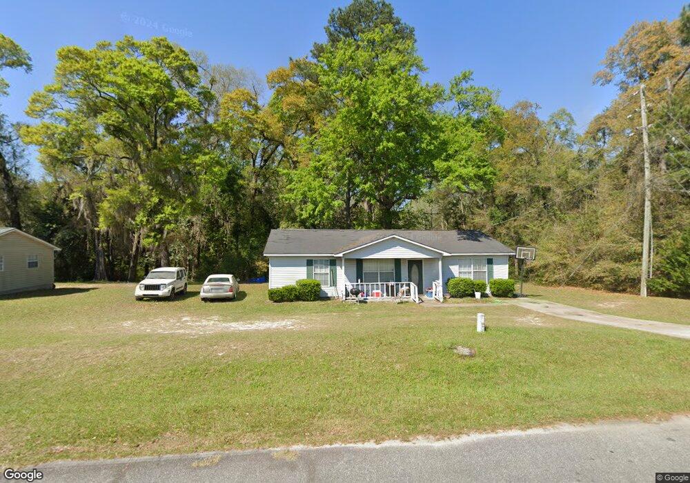
This home is located at 425 Bay Tree Rd, Cairo, GA 39828 and is currently estimated at $183,483, approximately $153 per square foot. 425 Bay Tree Rd is a home located in Grady County with nearby schools including Cairo High School.
Ownership History
Date
Name
Owned For
Owner Type
Purchase Details
Closed on
Aug 1, 2002
Bought by
Miller Tiffany M
Current Estimated Value
Purchase Details
Closed on
Oct 6, 2001
Sold by
Blake Gledis J
Bought by
Bank Of Grady County
Purchase Details
Closed on
Apr 18, 1996
Sold by
Tandem Dev Inc
Bought by
Blake Gledis J
Purchase Details
Closed on
Nov 22, 1995
Sold by
Johnson - Stoddard Inc
Bought by
Tandem Dev Inc
Purchase Details
Closed on
Mar 31, 1991
Bought by
Johnson - Stoddard Inc
Create a Home Valuation Report for This Property
The Home Valuation Report is an in-depth analysis detailing your home's value as well as a comparison with similar homes in the area
Purchase History
| Date | Buyer | Sale Price | Title Company |
|---|---|---|---|
| Miller Tiffany M | $59,200 | -- | |
| Bank Of Grady County | -- | -- | |
| Blake Gledis J | $56,000 | -- | |
| Tandem Dev Inc | -- | -- | |
| Johnson - Stoddard Inc | -- | -- |
Source: Public Records
Tax History
| Year | Tax Paid | Tax Assessment Tax Assessment Total Assessment is a certain percentage of the fair market value that is determined by local assessors to be the total taxable value of land and additions on the property. | Land | Improvement |
|---|---|---|---|---|
| 2025 | $1,239 | $46,440 | $12,360 | $34,080 |
| 2024 | $1,239 | $42,780 | $12,360 | $30,420 |
| 2023 | $1,229 | $34,872 | $6,000 | $28,872 |
| 2022 | $1,281 | $34,872 | $6,000 | $28,872 |
| 2021 | $1,284 | $34,872 | $6,000 | $28,872 |
| 2020 | $1,288 | $34,872 | $6,000 | $28,872 |
| 2019 | $1,288 | $34,872 | $6,000 | $28,872 |
| 2018 | $1,225 | $34,872 | $6,000 | $28,872 |
| 2017 | $1,178 | $34,872 | $6,000 | $28,872 |
| 2016 | $1,017 | $29,652 | $6,000 | $23,652 |
| 2015 | $1,007 | $29,652 | $6,000 | $23,652 |
| 2014 | $1,007 | $29,652 | $6,000 | $23,652 |
| 2013 | -- | $26,520 | $6,000 | $20,520 |
Source: Public Records
Map
Nearby Homes
- 408 Bay Tree Rd NE
- 0 20th St NE
- 00 20th St NE
- 711 2nd Ave NE
- 0 State Route 188
- 00 State Route 188
- 66 22nd St NE
- 00 Blackberry Ln
- 00 Meridian Rd
- 00 Cuffhead Rd
- 00 Union Hill Rd
- 2975 U S 84
- 2690 U S 84
- 21 24th St NE
- 4761 Hadley Ferry Rd
- 79 27th St NE
- 78.6 Ac Strickland Rd
- 592 20th St SE
- 309 3rd St SE
- 112 9th Ave NW
- 421 Bay Tree Rd
- 422 Bay Tree Rd
- 417 Bay Tree Rd
- 1951 Oak Dr
- 518 Bay Tree Rd
- 520 Bay Tree Rd
- 520 Bay Tree Rd NE
- 412 Bay Tree Rd
- 433 Bay Tree Rd
- 413 Bay Tree Rd
- 514 Bay Tree Rd
- 1961 Oak Dr
- 516 Bay Tree Rd
- 409 Bay Tree Rd
- lot 9 Bay Tree Rd NE
- 409 Bay Tree Rd
- 411 Hickory Cir
- 408 Bay Tree Rd
- 443 Bay Tree Rd
- 510 Bay Tree Rd
Your Personal Tour Guide
Ask me questions while you tour the home.