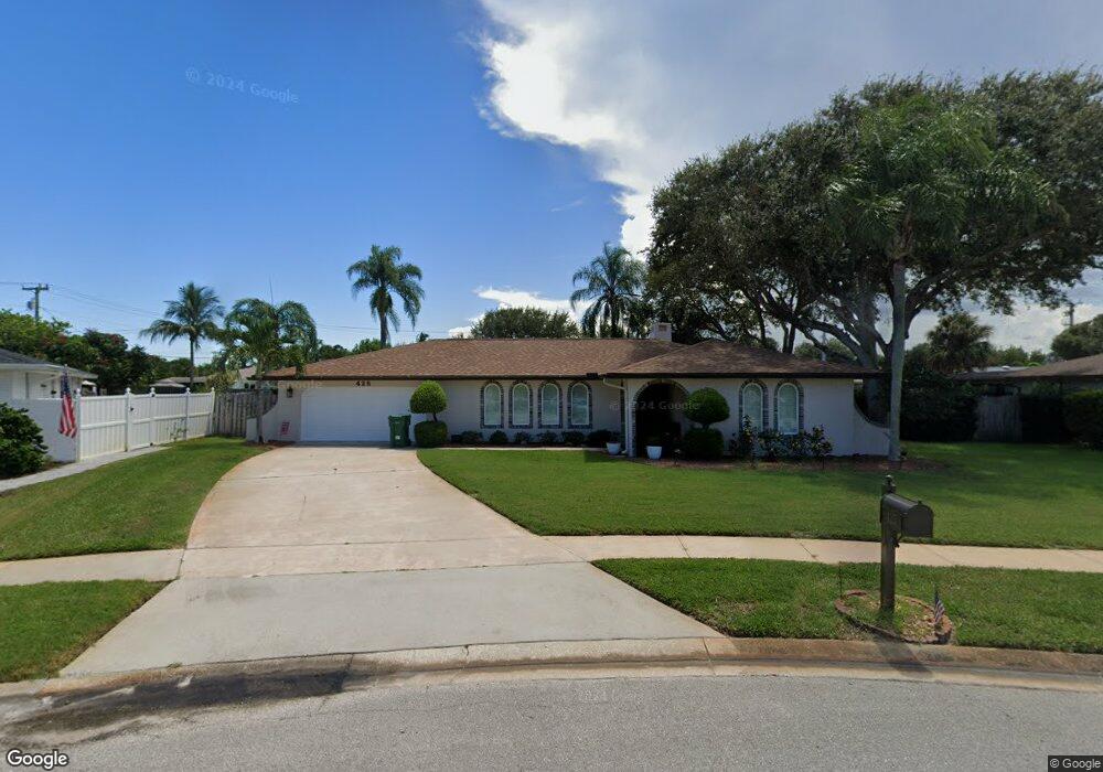
425 E Amherst Cir Satellite Beach, FL 32937
Estimated Value: $618,931 - $706,000
3
Beds
2
Baths
2,087
Sq Ft
$318/Sq Ft
Est. Value
About This Home
This home is located at 425 E Amherst Cir, Satellite Beach, FL 32937 and is currently estimated at $663,233, approximately $317 per square foot. 425 E Amherst Cir is a home located in Brevard County with nearby schools including Surfside Elementary School, Satellite Senior High School, and DeLaura Middle School.
Ownership History
Date
Name
Owned For
Owner Type
Purchase Details
Closed on
Oct 16, 2009
Sold by
Haynes Edward Joseph and Haynes Jeannine Keane
Bought by
Haynes Marjorie Jean
Current Estimated Value
Create a Home Valuation Report for This Property
The Home Valuation Report is an in-depth analysis detailing your home's value as well as a comparison with similar homes in the area
Home Values in the Area
Average Home Value in this Area
Purchase History
We collect this data history from publicly available records. To have your information removed, we recommend requesting removal directly through your county’s website.
| Date | Buyer | Sale Price | Title Company |
|---|---|---|---|
| Haynes Marjorie Jean | -- | Attorney |
Source: Public Records
Tax History
| Year | Tax Paid | Tax Assessment Tax Assessment Total Assessment is a certain percentage of the fair market value that is determined by local assessors to be the total taxable value of land and additions on the property. | Land | Improvement |
|---|---|---|---|---|
| 2025 | $3,007 | $197,320 | -- | -- |
| 2024 | $2,957 | $191,760 | -- | -- |
| 2023 | $2,957 | $186,180 | $0 | $0 |
| 2022 | $2,770 | $180,760 | $0 | $0 |
| 2021 | $2,853 | $175,500 | $0 | $0 |
| 2020 | $2,843 | $173,080 | $0 | $0 |
| 2019 | $2,823 | $169,190 | $0 | $0 |
| 2018 | $2,824 | $166,040 | $0 | $0 |
| 2017 | $2,648 | $162,630 | $0 | $0 |
| 2016 | $2,656 | $159,290 | $85,000 | $74,290 |
| 2015 | $2,720 | $158,190 | $75,000 | $83,190 |
| 2014 | $2,723 | $156,940 | $70,000 | $86,940 |
Source: Public Records
Map
Nearby Homes
- 400 Maria Dr
- 409 Saint Johns Dr
- 517 Summerset Ct
- 602 Desoto Ln
- 519 Summerset Ct
- 414 Hawthorne Ct
- 429 Saint Johns Dr
- 695 Trinidad Ct
- 413 Trinidad Dr
- 280 Lynn Ave
- 480 Temple St
- 276 Lynn Ave
- 655 N Robin Way
- 105 Carissa Dr
- 521 Island Ct
- 366 Ocean Spray Ave
- 107 Windward Way
- 35 Anchor Dr
- 129 Island View Dr
- 122 Windward Way
- 421 E Amherst Cir
- 420 Desoto Pkwy
- 430 Desoto Pkwy
- 410 Desoto Pkwy
- 430 E Amherst Cir
- 435 E Amherst Cir
- 415 E Amherst Cir
- 440 Desoto Pkwy
- 590 Kale St
- 416 E Amherst Cir
- 598 Kale St
- 441 E Amherst Cir
- 411 E Amherst Cir
- 450 Desoto Pkwy
- 450 E Amherst Cir
- 580 Kale St
- 410 E Amherst Cir
- 460 E Amherst Cir
- 425 Desoto Pkwy
- 445 E Amherst Cir
Your Personal Tour Guide
Ask me questions while you tour the home.