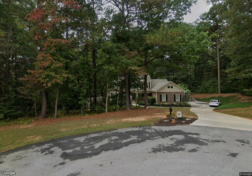
425 Wildwind Trace Dallas, GA 30132
Cedarcrest NeighborhoodEstimated Value: $662,000 - $744,000
About This Home
This home is located at 425 Wildwind Trace, Dallas, GA 30132 and is currently estimated at $696,756, approximately $195 per square foot. 425 Wildwind Trace is a home located in Paulding County with nearby schools including Burnt Hickory Elementary School, Sammy Mcclure Sr. Middle School, and North Paulding High School.
Ownership History
We collect this data history from publicly available records. To have your information removed, we recommend requesting removal directly through your county’s website.
Purchase Details
Home Financials for this Owner
Home Financials are based on the most recent Mortgage that was taken out on this home.Purchase Details
Home Financials for this Owner
Home Financials are based on the most recent Mortgage that was taken out on this home.Purchase Details
Home Financials for this Owner
Home Financials are based on the most recent Mortgage that was taken out on this home.Home Values in the Area
Average Home Value in this Area
Purchase History
We collect this data history from publicly available records. To have your information removed, we recommend requesting removal directly through your county’s website.
| Date | Buyer | Sale Price | Title Company |
|---|---|---|---|
| $49,900 | -- | ||
| $49,900 | -- | ||
| $49,900 | -- |
Mortgage History
We collect this data history from publicly available records. To have your information removed, we recommend requesting removal directly through your county’s website.
| Date | Status | Borrower | Loan Amount |
|---|---|---|---|
| Previous Owner | $42,000 |
Tax History
We collect this data history from publicly available records. To have your information removed, we recommend requesting removal directly through your county’s website.
| Year | Tax Paid | Tax Assessment Tax Assessment Total Assessment is a certain percentage of the fair market value that is determined by local assessors to be the total taxable value of land and additions on the property. | Land | Improvement |
|---|---|---|---|---|
| 2025 | $5,602 | $228,540 | $30,000 | $198,540 |
| 2024 | $5,988 | $243,960 | $30,000 | $213,960 |
| 2023 | $6,522 | $252,688 | $30,000 | $222,688 |
| 2022 | $5,635 | $218,032 | $30,000 | $188,032 |
| 2021 | $4,887 | $170,040 | $30,000 | $140,040 |
| 2020 | $4,525 | $154,208 | $30,000 | $124,208 |
| 2019 | $3,916 | $131,820 | $30,000 | $101,820 |
| 2018 | $4,434 | $149,028 | $30,000 | $119,028 |
| 2017 | $4,485 | $146,824 | $30,000 | $116,824 |
| 2016 | $4,234 | $140,040 | $30,000 | $110,040 |
| 2015 | $4,745 | $154,160 | $30,000 | $124,160 |
| 2014 | $4,187 | $132,640 | $30,000 | $102,640 |
| 2013 | -- | $131,240 | $30,000 | $101,240 |
Map
- 210 Burnt Hickory Dr
- 166 Windrift Dr
- 10266 Cartersville Hwy
- 40 Hickory Ln
- 49 Majestic Oak Cir
- 682 Ferguson Place
- 30 Stephen Ct
- 441 Reidland Dr
- 78 Foxdale Way
- 339 Pioneer Trail
- 0 Ponderosa Trail Unit 10763746
- 0 Ponderosa Trail Unit 7770097
- 306 Timothy Dr
- 790 Ferguson Place
- 449 Hollingshed Rd
- 856 Ferguson Place
- 95 Luke Dr
- 2607 Cochran Rd
- 1569 Dabbs Bridge Rd
- 1585 Dabbs Bridge Rd
- 401 New Farm Rd
- 381 New Farm Rd
- 402 New Farm Rd
- 380 New Farm Rd
- 369 New Farm Rd
- 420 Wildwind Trace
- 420 Wildwind Trace Unit 76
- 354 New Farm Rd
- 323 New Farm Rd
- 389 Wildwind Trace
- 400 Wildwind Trace
- 297 New Farm Rd
- 371 Wildwind Trace
- 95 Windchase Ct
- 350 Wildwind Trace
- 324 New Farm Rd
- 350 New Farm Rd
- 100 Windchase Ct
- 280 New Farm Rd
- 80 Windchase Ct Unit N/A
Ask me questions while you tour the home.