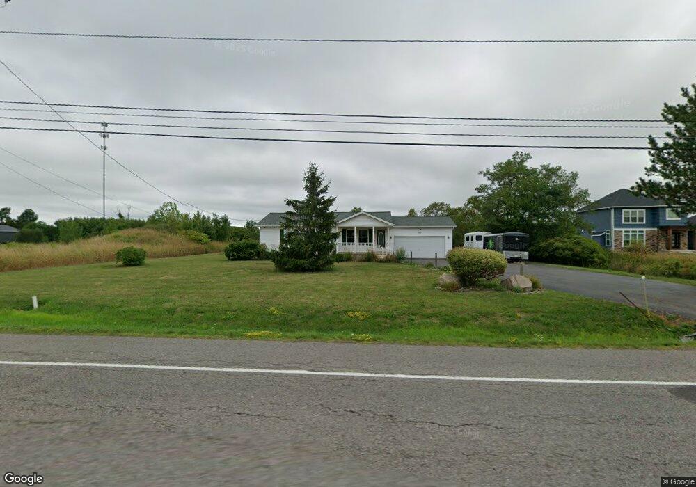
4287 Lockport Rd Lockport, NY 14094
Estimated Value: $270,463 - $334,000
3
Beds
2
Baths
1,120
Sq Ft
$259/Sq Ft
Est. Value
About This Home
This home is located at 4287 Lockport Rd, Lockport, NY 14094 and is currently estimated at $289,866, approximately $258 per square foot. 4287 Lockport Rd is a home located in Niagara County with nearby schools including Fricano Primary School, Regan Intermediate School, and Starpoint Middle School.
Ownership History
Date
Name
Owned For
Owner Type
Purchase Details
Closed on
Sep 7, 2010
Sold by
Spencer Patrice A and Sandera William E
Bought by
Morris Cynthia S
Current Estimated Value
Home Financials for this Owner
Home Financials are based on the most recent Mortgage that was taken out on this home.
Original Mortgage
$125,900
Outstanding Balance
$83,304
Interest Rate
4.48%
Mortgage Type
New Conventional
Estimated Equity
$206,562
Purchase Details
Closed on
Oct 15, 2004
Sold by
Wachowicz Michael
Bought by
Mcw Construction Inc
Create a Home Valuation Report for This Property
The Home Valuation Report is an in-depth analysis detailing your home's value as well as a comparison with similar homes in the area
Home Values in the Area
Average Home Value in this Area
Purchase History
| Date | Buyer | Sale Price | Title Company |
|---|---|---|---|
| Morris Cynthia S | $139,900 | None Available | |
| Mcw Construction Inc | $30,000 | Michael R Belczak |
Source: Public Records
Mortgage History
| Date | Status | Borrower | Loan Amount |
|---|---|---|---|
| Open | Morris Cynthia S | $125,900 |
Source: Public Records
Tax History
| Year | Tax Paid | Tax Assessment Tax Assessment Total Assessment is a certain percentage of the fair market value that is determined by local assessors to be the total taxable value of land and additions on the property. | Land | Improvement |
|---|---|---|---|---|
| 2024 | $5,025 | $220,000 | $28,800 | $191,200 |
| 2023 | $4,841 | $209,800 | $28,800 | $181,000 |
| 2022 | $5,597 | $157,900 | $22,200 | $135,700 |
| 2021 | $5,405 | $157,900 | $22,200 | $135,700 |
| 2020 | $4,637 | $157,900 | $22,200 | $135,700 |
| 2019 | $4,494 | $157,900 | $22,200 | $135,700 |
| 2018 | $4,491 | $157,900 | $22,200 | $135,700 |
| 2017 | $4,494 | $157,900 | $22,200 | $135,700 |
| 2016 | $4,627 | $139,900 | $17,400 | $122,500 |
| 2015 | -- | $139,900 | $17,400 | $122,500 |
| 2014 | -- | $139,900 | $17,400 | $122,500 |
Source: Public Records
Map
Nearby Homes
- 6040 Aiken Rd
- 4283 Lockport Rd
- 4175 Lockport Rd
- 6082 Townline Rd
- 5830 Diller Rd
- V/L 6721 Aiken Rd
- 6107 Shawnee Rd
- 5831 Shawnee Rd
- 3849 Mapleton Rd
- 5848 Shawnee Rd
- 3959 Wheatfield Crossing
- 0 Cambria Rd
- 3947 Wheatfield Crossing
- 4797 Beach Ridge Rd
- 3863 Ridgeland Dr
- 3894 Wheatfield Crossing Rd
- 3839 Ridgeland Dr
- 3918 Wheatfield Crossing
- 3936 Wheatfield Crossing
- 6342 Campbell Blvd
- 4279 Lockport Rd
- 4203 Lockport Rd
- 4219 Lockport Rd
- 4231 Lockport Rd
- 4257 Lockport Rd
- 4263 Lockport Rd
- 4271 Lockport Rd
- 4225 Lockport Rd
- 4243 Lockport Rd
- 4264 Lockport Rd
- 4246 Lockport Rd
- 4234 Lockport Rd
- 4412 Lockport Rd
- 4222 Lockport Rd
- 4212 Lockport Rd
- 4202 Lockport Rd
- 4196 Lockport Rd
- 4369 Lockport Rd
- 4190 Lockport Rd
- 4377 Lockport Rd
Your Personal Tour Guide
Ask me questions while you tour the home.