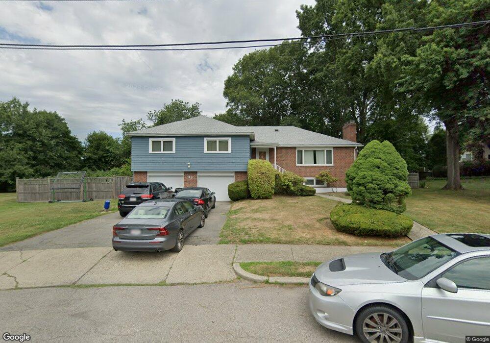
43 Levbert Rd Newton Center, MA 02459
Oak Hill NeighborhoodEstimated Value: $1,949,000 - $2,405,000
4
Beds
3
Baths
2,216
Sq Ft
$935/Sq Ft
Est. Value
About This Home
This home is located at 43 Levbert Rd, Newton Center, MA 02459 and is currently estimated at $2,071,871, approximately $934 per square foot. 43 Levbert Rd is a home located in Middlesex County with nearby schools including Memorial Spaulding Elementary School, Charles E Brown Middle School, and Oak Hill Middle School.
Ownership History
Date
Name
Owned For
Owner Type
Purchase Details
Closed on
Feb 7, 2014
Sold by
Perrin Scott D and Perrin Amy S
Bought by
Perrin Scott D
Current Estimated Value
Purchase Details
Closed on
Jun 13, 2006
Sold by
Danin Ft and Berger Dale
Bought by
Perrin Amy S and Perrin Scott D
Home Financials for this Owner
Home Financials are based on the most recent Mortgage that was taken out on this home.
Original Mortgage
$125,000
Interest Rate
6.62%
Mortgage Type
Purchase Money Mortgage
Create a Home Valuation Report for This Property
The Home Valuation Report is an in-depth analysis detailing your home's value as well as a comparison with similar homes in the area
Home Values in the Area
Average Home Value in this Area
Purchase History
| Date | Buyer | Sale Price | Title Company |
|---|---|---|---|
| Perrin Scott D | -- | -- | |
| Perrin Amy S | $855,000 | -- |
Source: Public Records
Mortgage History
| Date | Status | Borrower | Loan Amount |
|---|---|---|---|
| Previous Owner | Perrin Amy S | $125,000 |
Source: Public Records
Tax History
| Year | Tax Paid | Tax Assessment Tax Assessment Total Assessment is a certain percentage of the fair market value that is determined by local assessors to be the total taxable value of land and additions on the property. | Land | Improvement |
|---|---|---|---|---|
| 2025 | $16,557 | $1,689,500 | $1,452,600 | $236,900 |
| 2024 | $16,009 | $1,640,300 | $1,410,300 | $230,000 |
| 2023 | $15,147 | $1,487,900 | $1,125,300 | $362,600 |
| 2022 | $14,493 | $1,377,700 | $1,041,900 | $335,800 |
| 2021 | $13,985 | $1,299,700 | $982,900 | $316,800 |
| 2020 | $13,569 | $1,299,700 | $982,900 | $316,800 |
| 2019 | $13,186 | $1,261,800 | $954,300 | $307,500 |
| 2018 | $12,613 | $1,165,700 | $857,800 | $307,900 |
| 2017 | $12,229 | $1,099,700 | $809,200 | $290,500 |
| 2016 | $11,696 | $1,027,800 | $756,300 | $271,500 |
| 2015 | $11,153 | $960,600 | $706,800 | $253,800 |
Source: Public Records
Map
Nearby Homes
- 22 Burdean Rd
- 73 Hartman Rd
- 41 Juniper Ln
- 150 Country Club Rd
- 93 Sevland Rd
- 124 Deborah Rd
- 28 Cottonwood Rd
- 82 Sharpe Rd
- 71 Farina Rd
- 63 Drumlin Rd
- 99 Baldpate Hill Rd
- 447 Dudley Rd
- 458 Dudley Rd
- 459 Dudley Rd
- 405 Parker St Unit 405
- 136 Dudley Rd
- 50 Lovett Rd
- 85 Dudley Rd
- 51 Marcellus Dr
- 25 Lovett Rd
- 37 Levbert Rd
- 51 Levbert Rd
- 56 Littlefield Rd
- 48 Littlefield Rd
- 48 Littlefield Rd Unit O
- 38 Levbert Rd
- 68 Littlefield Rd
- 29 Levbert Rd
- 40 Littlefield Rd
- 57 Levbert Rd
- 62 Littlefield Rd
- 60 Levbert Rd
- 76 Littlefield Rd
- 53 Littlefield Rd
- 28 Levbert Rd
- 21 Levbert Rd
- 59 Littlefield Rd
- 32 Littlefield Rd
- 45 Littlefield Rd
- 68 Levbert Rd
Your Personal Tour Guide
Ask me questions while you tour the home.